- Yokohama-shi Top Page
- Living and Procedures
- Community Development and Environment
- Roads
- Construction
- Urban planning roads
- In-business routes
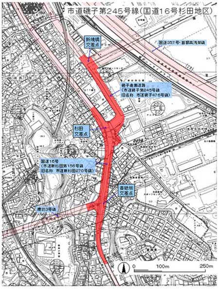
- City Road Isogo Route 245 (National Route 16) Sugita district
Here's the text.
City Road Isogo Route 245 (National Route 16) Sugita district
Last update date April 1, 2024
In order to strengthen the communication between Route 3 and the coastal area, we are promoting a project to widen the section from Aotosaka intersection at the starting point of Route 3 to the Shinsakai Bridge intersection on the Isogo Industrial Road (City Road Isogo Route 245). . Of this section, general national highway No. 16 (city road Shinsugita No. 156) is operated jointly with the Ministry of Land, Infrastructure, Transport and Tourism.
| Business district | City Road Isogo Route 245 (National Route 16) Sugita district (Old name City Road Isogo Route 476) |
|---|---|
| Section | From 5-chome Sugita, Isogo-ku (near Shinsakai Bridge Intersection of Isogo Industrial Road) To Kanazawa Ward Tomioka-Higashi 1-chome (near Aotozaka intersection on Route 3) |
| Process | 1987 National Highway No. 16 city planning change (width 22m → 28m) Started land acquisition in fiscal 1992 April 1999 A right turn lane was installed on the Route 1 down line (approximately 300m) in line with the operation of Route 3. |
| Scale |
|
| Maintenance effect |
|
| Business progress rate※ | 86% (Estimated by the end of FY2023) |
| Land acquisition rate※ | 89% (estimated as of the end of FY2023) |
| Related information | Ministry of Land, Infrastructure, Transport and Tourism Kanto Regional Development Bureau Yokohama National Highway Office homepage (road business / general national highway No. 16 / Sugita intersection improvement) (outside site) |
※The business progress rate is shown as the execution rate of total operating expenses.
※The land acquisition rate shows the ratio of the acquired area among the areas that have been approved for business.

Business Section
| From Sugita Intersection to Shin-Sugita Station | From Sugita Intersection to Aotozaka Intersection |
|---|---|
Inquiries to this page
Construction Division, Construction Department, Road and Highway Bureau Construction Department
Telephone: 045-671-3521
Telephone: 045-671-3521
Fax: 045-663-8993
Email address: do-kensetsu@city.yokohama.lg.jp
Page ID: 953-819-309


