


- Yokohama-shi Top Page
- Midori Ward Top Page
- Introduction of the ward
- Midori Ward Heritage
- List of Midori Ward Heritage Sites
- First class triangular point "Nagatsuda Village"
Here's the text.
First class triangular point "Nagatsuda Village"
Last Updated December 1, 2023
First class triangular point "Nagatsudamura" (registration number 022) Registered in 2023
About the first-class triangular point "Nagatsuda Village"
In the Meiji era, first-class triangular points were set up nationwide with the aim of grasping the national land with unified standards and high accuracy. Triangles of triangles made at first-class triangular points were layered, and a first-class triangular net, which is the framework of the map, was created. The only first-class triangular point in Yokohama is Nagatsuda Village on the summit of Mount Takao.
Triangle measurement is a surveying method that measures the angle of the triangle and calculates the magnitude of the triangle by calculation. For this reason, the first side (baseline), which is the basis for subsequent calculations, was actually measured as a straight line.
With the Sagamino Baseline (*), which was observed at 5209.9697m in 1882, the triangle was formed in 1883 with the first triangular point "Nagatsuda Village" as the first increase point (the top of the triangle). It was connected to a first-class triangular network covering the whole country.
After that, over 30 years, a 1/50,000 topographic map, which is the basic map of the national land, will be developed, and efforts to grasp the national land with unified standards and high accuracy have started here.
The pillar of "Nagatsuda Village" remains a stone buried in 1883 with a total length of 83.2 cm and a weight of about 90 kg.
※Sagamino Baseline: A straight line connecting the first-class triangular point "Shimomizo Village" (Sagamihara City designated cultural property "Sagamino Kisenkita end point" and the first-class triangular point "Zama Village" (Zama City designated important cultural property "Sagamino base line southern end point") It was observed at 5209.9697m in 1882. It has become a civil engineering heritage selected by the Japan Society of Civil Engineers as the birthplace of modern surveying in Japan.
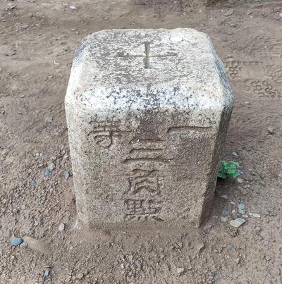
▲First-class triangular point "Nagatsuda Village"
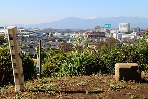
▲First class triangular point
[View from Mount Takao]
On a sunny winter day, you can see the mountain ridges beautifully.
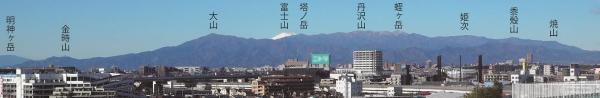
▲The Tanzawa Mountains from near the top of Mount Takao (taken on February 10, 2021)
※The name and position of the mountain are approximate.
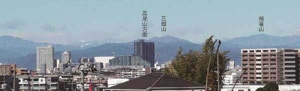
▲Mount Takao (Hachioji City, Tokyo) from Mount Takao Mountain Road (taken on February 10, 2021)
※The name and position of the mountain are approximate.
Location:
5617, Nagatsutacho, Midori-ku, Yokohama-shi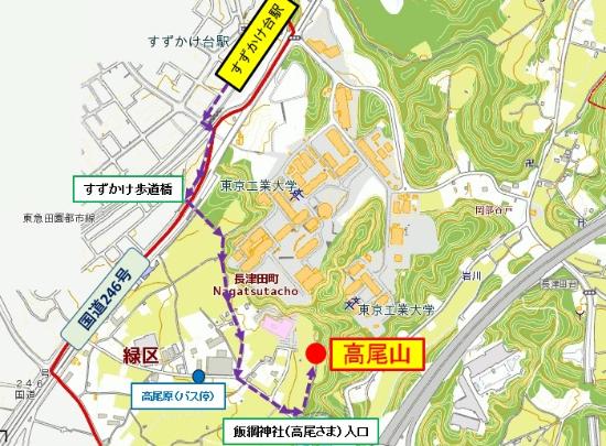
[Bus route]
From Nagatsuta Station (South Exit) on the JR Yokohama Line / Tokyu Denentoshi Line
From Minamimachida Station (North Exit) on the Tokyu Denentoshi Line
■Take the Kananaka Bus [Tsu 1 System] and get off at the bus stop "Takaohara" and walk 10 minutes.
Inquiries to this page
Midori Ward General Affairs Department Ward Administration Promotion Division Public Relations Section
Telephone: 045-930-2219
Telephone: 045-930-2219
Fax: 045-930-2225
Email address: md-home@city.yokohama.jp
Page ID: 983-825-122


