Here's the text.
K-004: Izumimiyako district
City planning decision: April 15, 1994 / City planning change: May 10, 1996
Last Updated December 9, 2022
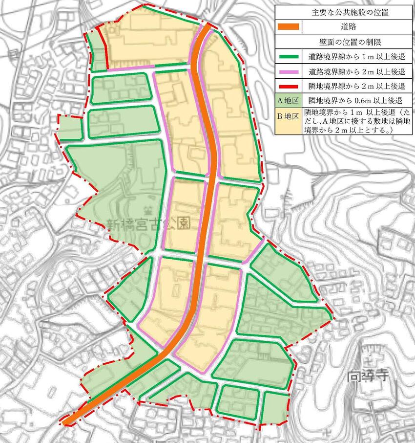
 Plan drawing (division of district, location of major public facilities, restriction of position of wall)
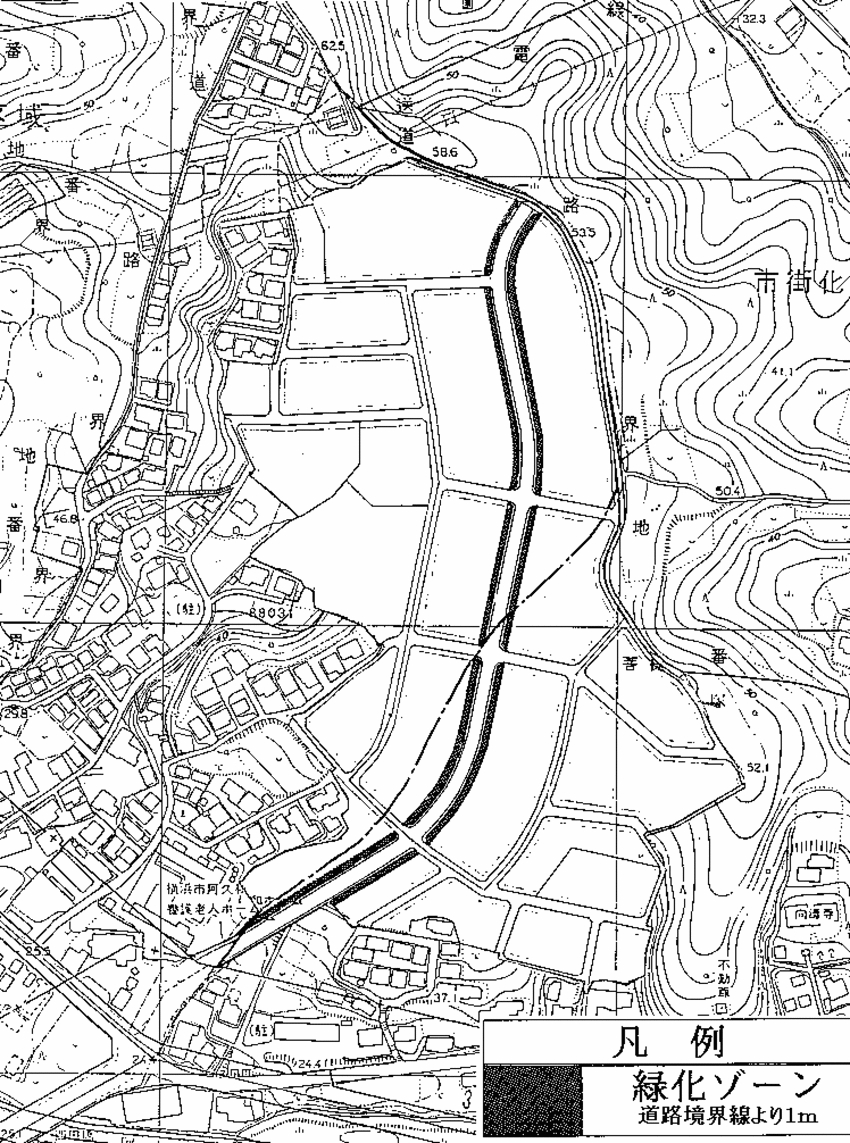
 Plan drawing (greening zone)
| Name | Izumi-Miko district residential area advanced use district plan | ||
|---|---|---|---|
| Position | Ozu-cho and Shimbashi-cho, Izumi-ku, Yokohama-shi | ||
| Area | About 8.1ha | ||
| Ward Areas No 1. Bill ・ Opening Departure Ma'am Ha Hoping All No Sir Needle |
Targets of residential area advanced use district planning | The Area is located approximately 1 km east of Yayoidai Station on the Sotetsu Izumino Line and approximately 1 km south of Midorien-shi Station, and is positioned as a planned residential area under the Yokohama 21st Century Plan Izumi Ward Plan. At present, infrastructure development is being promoted through land readjustment projects, and it is a district where sound residential urban areas are maintained. Therefore, in this area, by guiding urban housing systematically and integrally, we plan to create a good living environment and supply a planned residential area, thereby maintaining and improving the effects of attractive town development and development projects. Strive for This residential area advanced use district plan forms a good residential area including middle- and high-rise houses by promoting the advanced use of land while harmonizing with the surrounding urban area in line with the maintenance of necessary public facilities. The goal is to maintain the environment. |
|
| Basic Policy on Land Use | Divide two districts and guide land use according to their respective policies. In addition, in order to create an attractive environment along the main roads in the district, we will strive to maintain and conservation a "greening zone" by planting a width of 1 m from the road boundary. 1 Area A |
||
| Policy for the development of urban infrastructure | In order to improve the convenience of the surrounding area and ensure the safety and convenience of traffic as a middle- and high-rise residential area, a new arterial road in the area that runs north and south through the center of the district will be newly established and the division roads will be properly arranged. In addition, a park of an appropriate size will be placed so that it can be used as a place for community formation and health maintenance and promotion of local residents. |
||
| Policy for maintenance of buildings, etc. | For individuality and attractive town development, in district B, we plan guidance of planned and integrated building. Harmony between low-rise houses and middle-high-rise houses, and create a comfortable and unique cityscape along the main roads in the district. We establish policy of maintenance of building as follows according to each district characteristic. In addition to greening the site, a parking lot commensurate with the number of dwelling units will be set up in apartment, and a parking lot of an appropriate scale will be provided for convenience facilities. 1 Area A |
||
| Placement and scale of major public facilities | Roads (main roads in the district) | Width: 10m, length: 490m | |
| k-004 Residential Area Advanced Utilization Area Development Plan | ||||
|---|---|---|---|---|
| Construction Construction Goods Etc. Ni Seki S L A matter Section |
Classification of district | Name | District A | District B |
| Area | About 4.2ha | About 3.9ha | ||
| Maximum ratio of total building area to site area | ―― | On site adjacent to arterial road in district, it shall be 15/10. However, the total area includes car garages and other facilities exclusively for stopping or parking cars or bicycles (including guide lanes, maneuvering places, and boarding places). The floor area of the part to be used for use is the total floor area of each floor of the building on the site (if there are two or more buildings on the same site, the floor area of each floor of those buildings Is not included up to one-fifth of the total). |
||
| Maximum ratio of building area to site area of building | ―― | On site adjacent to arterial road in district, it shall be 6/10. | ||
| Minimum site area of buildings | The site area of the building shall be more than 150m2 and the area obtained by multiplying the number of dwelling units by 45m2. | The site area of the building shall be more than 300m2 and the area obtained by multiplying the number of dwelling units by 40m2. | ||
| Provided, however, that this shall not apply to any of the following. 1 Land used as a site for public toilets, police station offices and other similar buildings necessary for the public interest |
||||
| Restrictions on the position of the wall | The distance from the outer wall of the building or the surface of the pillar in place of this to the boundary of the front road shall be 1 m or more, and the distance to the adjacent land boundary shall be 0.6 m or more. | 1 The outer wall of the building or the surface of the pillar in place of this shall not be built beyond the restriction of the position of the wall displayed in the plan drawing. 2 Unless otherwise indicated in the plan drawing, the distance from the outer wall of the building or the surface of the pillar in place of this to the adjacent land boundary shall be 1 m or more. |
||
| But it is not this limit when building or part of building which is less than limit of this distance outside "greening zone" corresponds to any of the following. 1 The total length of the center line of the outer wall or pillar in place of it is 3m or less |
||||
| Maximum height of buildings | ―― | 1 The height of the building must not exceed 18m. 2 The height of each part of the building must be less than the one obtained by multiplying the horizontal distance in the true north direction from each part to the boundary of District B by 0.5 and adding 4m. |
||
| Restrictions on forms or designs of buildings, etc. | ―― | The colors of the roof and outer wall of the 1 building and the colors, sizes and shapes of outdoor advertising materials shall be in harmony with the surrounding landscape. The roof of a building with a floor exceeding the fourth floor on the site in contact with the main road in the 2 districts shall have a shape with this arrangement. Provided, however, that this shall not apply to parts of the fourth floor or lower. |
||
| Restrictions on the structure of a fence or fence | Hedges, fences, and other similar openness. | |||
| Restrictions on Land Use | 1 Planting, etc. in the "greening zone" displayed in the plan drawing shall be maintained and preserved. Provided, however, that this shall not apply to the minimum necessary part for use. 2 Workpieces must not be built or installed in the "greening zone" displayed in the plan drawing. Provided, however, that this shall not apply if it is unavoidable for disaster prevention or public interest. |
|||
Inquiries to this page
Urban Development Bureau Regional Town Development Department Regional Town Development Division
Telephone: 045-671-2667
Telephone: 045-671-2667
Fax: 045-663-8641
Email address: tb-chiikimachika@city.yokohama.lg.jp
Page ID: 759-638-166


