


- Yokohama-shi Top Page
- Living and Procedures
- Community Development and Environment
- Urban Development
- District planning, building agreements, etc.
- District planning
- District planning for each ward
- Naka Ward
- S-002: Kitanakadori Minami Area Redevelopment District Plan
Here's the text.
S-002: Kitanakadori Minami Area Redevelopment District Plan
※The plan reads out statutory books in the form of a table, and it may be difficult to understand the contents. Please contact the Urban Revitalization Division for confirmation of the contents (Phone number: 045-671-2673)
Last Updated November 1, 2021
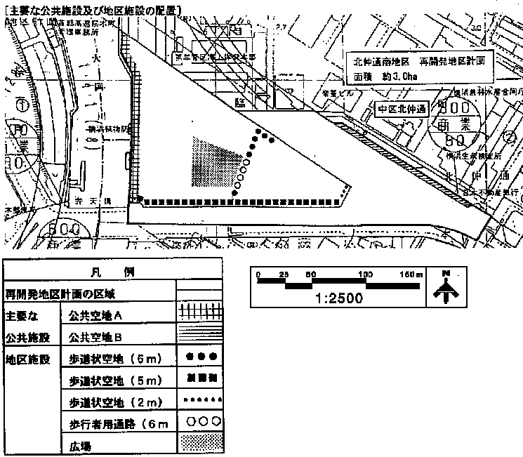
Plan drawings (district facilities)
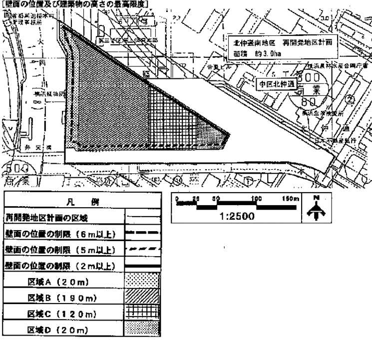
Plan drawing (restriction of wall position and maximum height of building)
| Name | Kitanakadori Minami Area Redevelopment District Plan | ||
|---|---|---|---|
| Position | Kitanakadori and Honmachi, Naka-ku, Yokohama | ||
| Area | About 3.0ha | ||
| Ward Areas No 1. Bill Oh Bi Opening Departure Ni Seki S L Sir Needle |
Targets of redevelopment district planning | In the Yumehama 2010 Plan, this area is positioned to be integrated with the Minato Mirai 21 district, etc. to enhance the functions of the city center. Therefore, the goal of this redevelopment district plan is to plan planned urban area formation in accordance with the following policy. 1 City planning road No. 3.1.7 Sakaehonmachi Line (hereinafter referred to as "Eihonmachi Line") In line with the development of the existing business urban area with reduced functions will be integrated, and the advanced use of integrated land will be promoted to strengthen the city center. 2 Maintain a safe and comfortable pedestrian space and strengthen the pedestrian network in the city center. 3 The redevelopment of the Minato Mirai 21 district will be a leading district for the development of Kannai-District. 4 Urban Expressway Minato Mirai 21 Line (hereinafter referred to as “Minatomirai 21 Line”) We will improve public vacant lots and pedestrian spaces around stations. |
|
| Basic Policy on Land Use | 1 We will introduce functions appropriate for the city center, centering on business facilities, and plan the location of commercial facilities, etc. to form the bustle of the city. 2 Aim for conservation of historical assets and utilize environmental resources such as maintenance of hydrophilic space. |
||
| Policy for maintenance of public facilities | 1 Establish the Sakaehonmachi Line to communicate with Minato Mirai 21 district and Kannai-District. As part of the development of promenades along the two major Okagawa rivers, we will develop public vacant lots as places for people to rest. 3 In front of the Minato Mirai 21 Line, secure a spacious space in consideration of the convenience of passengers, and maintain a safe and comfortable public open space to form a network with the surrounding promenade. 4 Urban planning roads No. 3.3.1 Honmachi Line, which are important pedestrian traffic lines (hereinafter referred to as the "Honmachi Line") We maintain open space, sidewalk-shaped open space and passage for pedestrian to plan improvement of pedestrian space along along and from Honmachi line toward station entrance. 5 In order to respond to the demand for parking lots in the city center, a parking lot of an appropriate scale will be developed taking into account the surrounding area. 6 The Minato Mirai 21 Line will be developed as a mass transportation system that responds to the enhancement of urban center functions. |
||
| Policy for maintenance of buildings, etc. | 1 The building will be a super high-rise building that symbolizes the junction between the Minato Mirai 21 district and the existing city center Kannai-District. 2 In order to harmonize with the surrounding streets, the height of the building shall be considered in consideration of the continuity with the existing streets, and the height of the building shall be gradually constructed on the site. 3 Create comfortable pedestrian spaces such as atrium (a covered open space where people gather), pedestrian decks, and pedestrian passages, and create a lively city. 4 The design will take advantage of historical assets and surrounding landscape and environmental resources, such as preservation of the former Daiichi Bank and maintenance of a waterside rest space. 5 The part along the Ooka River of the building shall be in a form that takes into account the open space function of public vacant lots. |
||
| Placement and scale of major public facilities | Public vacant space A | Area approximately 1,000 m2 | |
| Public open space B | Area approximately 900m2 | ||
| Redevelopment Area Development Plan | |||||||||||||
|---|---|---|---|---|---|---|---|---|---|---|---|---|---|
| Position | Kitanakadori and Honmachi, Naka-ku, Yokohama | ||||||||||||
| Area | About 3.0ha | ||||||||||||
| Placement and scale of district facilities | Width |
Extension | |||||||||||
| Sidewalk-like open space | 6m |
Approx. 55m | |||||||||||
| 5m | Approx. 190m | ||||||||||||
| 2m | About 20m | ||||||||||||
| Aisles for pedestrians | 6m | About 20m | |||||||||||
| Open space | Area approximately 1,200 m2 | ||||||||||||
| Construction Construction Goods Etc. Ni Seki S L A matter Section |
Restrictions on Use of Buildings, etc. | The following buildings must not be constructed. 1 Public baths pertaining to the bathhouse business with private rooms and other similar Building Standards Law Enforcement Ordinance (Government Ordinance No. 338 of 1950) Article 130-9-3 ※As defined in 2 Factories listed in Appendix 2 (and) Item 3 of the Building Standards Act (Act No. 201 of 1950) 3 Majangya, Pachinkoya, shooting range, Katsuma voting ticket sales office, off-site ticket sales office, and the like 4. For residential use (excluding caretaker housing) |
|||||||||||
| Maximum ratio of total building area to site area | 108/10 | ||||||||||||
| Maximum ratio of building area to site area of building | 8/10 | ||||||||||||
| Restrictions on the position of the wall | The outer wall of the building or the surface of the pillar in place of this shall not be built beyond the limit of the position of the wall shown in the plan drawing. But it is not this limit about building corresponding to any of the following or part of building. 1 Public toilets, police stations, and other similar public interest 2 Public corridors and other similar safety, disaster prevention and hygiene |
||||||||||||
| Maximum height of buildings | The height of the building in the area shown in the left column of the table below must not exceed the numerical value shown in the right column of the table below.
|
||||||||||||
| Restrictions on the form or design of buildings | 1 The outer wall of the first floor along the Ooka River of the building shall be an open form integrated with public vacant lots. The part facing 2 sidewalk-like open spaces, pedestrian passages, and open spaces shall be designed to make you feel the unity of forming a network of pedestrian traffic lines including the surrounding area and the bustle of the station square area. 3. To maximize the preservation and utilization of historical assets and environmental resources existing in the district, and actively incorporate and utilize these designs. For the part along the 4 Honmachi Line and the Sakaehonmachi Line, the wall will be retracted to create a space for pedestrians and create a continuous cityscape with the surrounding area. 5 The high-rise part of the building will be considered in consideration of the surrounding environment, and especially in the ultra-high-rise part, the sectioned design will reduce the feeling of oppression. About outdoor advertising matter to install in 6 buildings, we consider harmony with the surroundings after maintaining good cityscape scenery. |
||||||||||||
※Due to the revision of the Building Standards Law (enforced on April 1, 2018), Article 130-9-3 of the Building Standards Law Enforcement Order, which is described in "Restrictions on Use of Buildings, etc." Has been revised to Article 130-9-5.
The Kitanakadori Minami district is also designated as the "Kannai Landscape Plan / Kannai Landscape Consultation District".
- About the scenery of Kannai-District
"Landscape Planning and Urban Landscape Consultation Area" in Kannai-District
Inquiries to this page
Urban Renewal Division, Urban Development Bureau Urban Renewal Department
Telephone: 045-671-2673
Telephone: 045-671-2673
Fax: 045-664-3551
Email address: tb-tosai@city.yokohama.jp
Page ID: 720-086-471


