


Here's the text.
C-036: Minato Mirai 21 New Port Area
※The plan reads out statutory books in the form of a table, and it may be difficult to understand the contents. For confirmation of the contents, please contact the Minato Mirai / Toshin Nagawa Coastal Promotion Section (Phone number: 045-671-3516)
Last Updated April 3, 2023
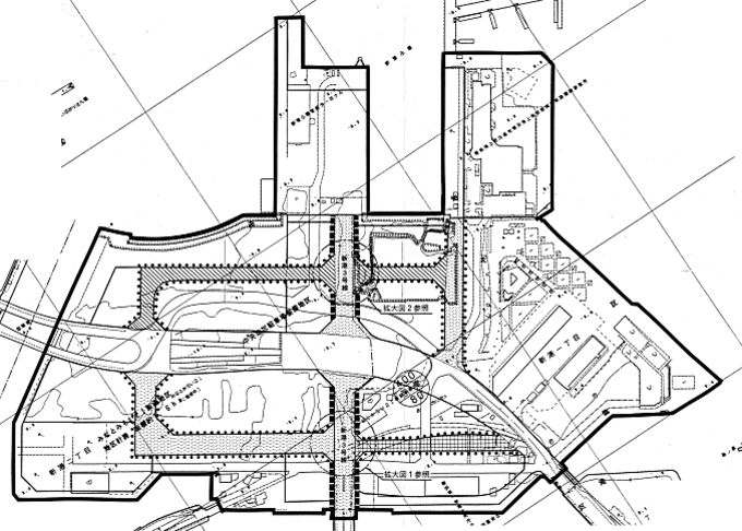
 Plan drawing (division of district)
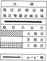 Legend
 Plan drawings (district facilities)
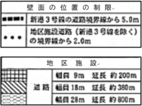 Legend
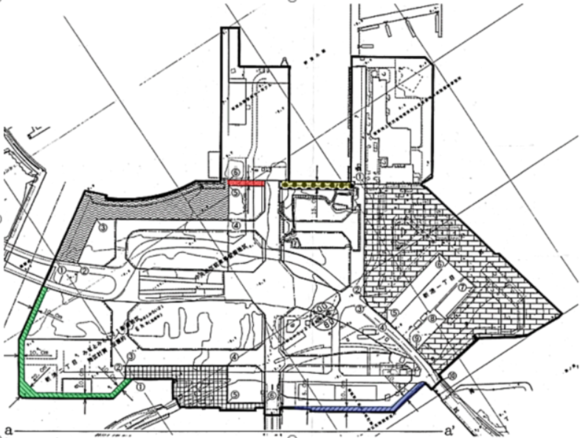 Plan (District Facilities 2)
 Legend
| Name | Minato Mirai 21 New Port District Planning | |
|---|---|---|
| Position | Shinko 1-chome and Shinko 2-chome, Naka-ku, Yokohama, and Shinko 1-chome and Shinko 2-chome | |
| Area | Approx. 36.4ha | |
| Ward Areas No 1. Bill ・ Opening Departure Oh Bi Hoping All No Sir Needle |
Targets of District Planning | This area is the birthplace of modern harbors with unique regional characteristics as an "island" and should be designed to create a cityscape in harmony with the surrounding area, such as harbor-related facilities that support Yokohama Port in the 21st century, lively facilities connecting Minato Mirai 21 Central District and Kannai-District, and green spaces that make use of the quiet inland water.
|
| Land Use Policy | In order to utilize the resources of the Area and form a harmonious port space, land use will be guided based on the following policies.
|
|
| Policy for the development of district facilities | The Area is located on the border line and is located in the corner of the pedestrian traffic line connecting to the surrounding area via Shinkobashi Bridge, Bankokubashi Bridge, Kokusaibashi Bridge and Kisha-Michi Promenade. For this reason, we will promote the development of district facilities based on the following policies.
|
|
| Policy for maintenance of buildings, etc. | In order to harmonize with the surrounding areas and make use of the characteristics of the waterfront, and to form a cityscape appropriate for the port and its history, we will guide the maintenance of buildings, etc. based on the following policies.
|
|
| District maintenance plan | |||||
|---|---|---|---|---|---|
| Placement and scale of district facilities | Roads | Width: 9m, length: 200m | |||
| Width: 18m, length: 380m | |||||
| Width: 28m, length: 800m | |||||
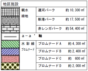
| Hydrophilic green space | 82,200 m2 (about 10,300 m2 in Canal Park, about 17,500 m2 in Shinko Park, about 54,400 m2 in Aka Renga Park (Red Brick Warehouse Park)) | ||||
| Bridal line promenade | Approx. 9,300m2 (Promenade A: approx. 4,300m2, Promenade B: approx. 2,400m2, Promenade C: approx. 600m2, Promenade D: approx. 2,000m2) | ||||
| Construction Construction Goods Etc. Ni Seki S L A matter Section |
Classification of district | Name | District A | District B | District C |
| Area | Approx. 11.6ha | Approx. 18.7ha | About 6.1ha | ||
| Restrictions on the use of buildings | Buildings listed in the following items shall not be constructed. Provided, however, that this shall not apply to buildings in subdivisions designated under the provisions of Article 39 of the Port Act (Act No. 218 of 1950).
|
||||
| Minimum site area of buildings | 2,500m2 | ||||
| Provided, however, that this shall not apply to land used as a site for public toilets, police officers, and other buildings necessary for the public interest. | |||||
| Restrictions on the position of the wall | The outer wall of the building or the surface of the pillar in place of this shall not be built beyond the limit of the position of the wall shown in the plan drawing. But part of building corresponding to any of the following or part of building is not this limit.
|
||||
| Maximum height of buildings | The height of the building must not exceed 31m. Provided, however, that if the following conditions are met, it may be 45m or less.
|
The height of the building must not exceed 31m. | The height of the building must not exceed 20m. | ||
| Restrictions on forms or designs of buildings, etc. |
|
||||
| Restrictions on the structure of a fence or fence | The installation of fences or fences shall be the minimum necessary for management, and hedges, fences, and other similar openness shall not impair the aesthetics. | ||||
※ Due to the revision of the Building Standards Law (enforced on April 1, 2018), Article 130-9-3 of the Building Standards Law Enforcement Order, which is described in "Restrictions on Use of Buildings, etc." Has been revised to Article 130-9-5.
You may need a separate PDF reader to open a PDF file.
If you do not have it, you can download it free of charge from Adobe.
![]() To download Adobe Acrobat Reader DC
To download Adobe Acrobat Reader DC
Inquiries to this page
Urban Development Bureau Central Revitalization Promotion Department Minatomirai and Toshin Nagawa Coastal Promotion Division
Telephone: 045-671-3516
Telephone: 045-671-3516
Fax: 045-651-3164
Email address: tb-mmhigashikanarin@city.yokohama.jp
Page ID: 348-945-086


