


Here's the text.
c-010: Minato Mirai 21 Central District
※The plan reads out statutory books in the form of a table, and it may be difficult to understand the contents. For confirmation of the contents, please contact the Minato Mirai / Toshin Nagawa Coastal Promotion Section (Phone number: 045-671-3516)
Last Updated May 31, 2024
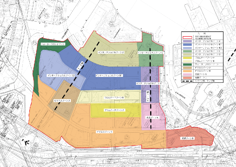
Plan drawing (division of district)
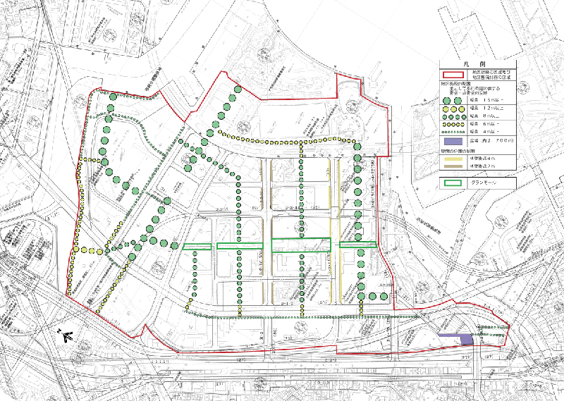
Plan drawing (district facilities and exterior wall retreat)
Enlarged figure (PDF: 38,345KB)
| Name | Minato Mirai 21 Central District District Planning | |
|---|---|---|
| Position | Takashima 1-chome, Nishi-ku, Minato Mirai 1-chome, Minato Mirai 2-chome, Minato Mirai 3-chome, Minato Mirai 4-chome, Minato Mirai 5-chome and Minato Mirai 6-chome, and Uchida-cho and Sakuragicho, Naka-ku | |
| Area | Approx. 115.7ha | |
| Targets of District Planning | This area is a business and commercial facility suitable for cities in the 21st century, in order to realize the Minato Mirai 21 Plan, which is the core business of Yokohama's city planning, which is positioned as a business core city that shares business functions in the Tokyo metropolitan area. It is a district that should be designed to introduce hotels, urban housing, various cultural facilities, and public utilities, as well as to create comfortable pedestrian spaces and harmonious cityscapes. For this reason, the purpose of this district plan is to plan a planned urban area formation with the aim of realizing the following urban image in conjunction with the "Minato Mirai 21 Town Planning Basic Agreement" concluded between landowners. 1.International Culture City, which operates 24 hours a day 2.Information City of the 21st Century 3.Human environment city surrounded by water, greenery and history |
|
| Ward Areas No 1. Bill 、 Opening Departure Oh Bi Hoping All Ni Seki S L Sir Needle |
Land Use Policy | In order to form a harmonious and balanced city suitable for cities in the 21st century, we will guide land use with distinctive characteristics in each of the following zones:
|
| Policy for maintenance of district facilities | 1.Create a network of safe and comfortable pedestrian spaces. 2.The open space on the king axis, mainly used for walking, will be an open mall, and a landscape space will be secured. 3.We will secure a plaza in Sakuragicho-sta. as a pedestrian space that creates liveliness. 4.Ensure open space with high openness in the appropriate position within the block. In the Minato Mirai 21 district, in order to enhance public spaces such as pedestrian networks, traffic bases, parks and green spaces, and waterside areas, pedestrian passages, atriums, etc. Secure external and internal open spaces such as sunken gardens, courtyards, and aerial plazas. |
|
| Policy for maintenance of buildings, etc. | In order to realize the formation of a cityscape suitable for the city center in the 21st century, buildings will be guided based on the following policies.
|
|
| c-010 District Development Plan | ||||||||
|---|---|---|---|---|---|---|---|---|
| Of district facilities Placement and scale |
Open space with blue sky and non-blue sky mainly used for walking | Width 15m or more Extended approximately 1,940m | ||||||
| Width 12m or more Extended approximately 120m | ||||||||
| Width of 8m or more Extended approximately 1,550m | ||||||||
| Width 6m or more Extended approximately 1,730m | ||||||||
| Width of 4m or more Extended approximately 2,650m | ||||||||
| Open space | Approx. 2,700 m2 | |||||||
| Construction Construction Goods Etc. Ni Seki S L A matter Section |
District No Category |
Name | Commercial zone | Business zone | Promenade zone | |||
| Subdivision | A | B | A | B | A | B | ||
| Area (ha) | Approx. 5.0 | Approx. 6.5 | Approx. 6.1 | Approx. 34.3 | Approx. 5.8 | Approx. 6.9 | ||
| Restrictions on Use of Buildings, etc. | The following buildings must not be constructed. Provided, however, that this shall not apply to buildings in subdivisions designated under the provisions of Article 39 of the Port Act (Act No. 218 of 1950).
|
|||||||
|
- | |||||||
| Minimum floor area ratio | 10/10 | |||||||
| Provided, however, that this shall not apply to those for provisional land use, those for construction on parks, plazas and similar land, and those for public interest such as public toilets, police stations and other similar public interest. | ||||||||
| Minimum site area of buildings | The entire block is used as a site. | 1,500 m2 | 5,000 m2 | 1,500 m2 | 2,500 m2 (1,500 m2 for sites other than buildings used for residential use) | |||
Provided, however, that this shall not apply to those that fall under any of the following items.
|
||||||||
| Restrictions on the position of the wall | The outer wall of buildings or the surface of the pillar in place of this shall not be built beyond the limit of the position of the wall shown in the plan drawing. But it is not this limit when building or part of building in distance less than limit of this distance corresponds to any of next kakugo.
|
|||||||
| Maximum height of buildings, etc. | The height of buildings, etc. must not exceed the numerical values listed below. Provided, however, that this shall not apply to those that fall under any of the following, as long as the formation of an orderly cityscape is not impaired.
|
|||||||
| 300m | 180m | 300m | 180m | 120m | ||||
| However, if the distance from the Grand Mall or Grand Mall Park border shown in the plan drawing is within 10 m, it shall be 20 m. | ||||||||
| Restrictions on form design of buildings, etc. | In order to arrange the scenery of the city, consider the colors of buildings and advertising materials to harmonize the entire district. | |||||||
| c-010 District Development Plan | ||||||||
|---|---|---|---|---|---|---|---|---|
| Construction Construction Goods Etc. Ni Seki S L A matter Section |
District No Category |
Name | International zone | Waterfront zone | ||||
| Subdivision | A | B1 | B2 | C | D | |||
| Area (ha) | Approx. 5.4 | Approx. 15.3 | Approx. 9.1 | Approx. 5.5 | Approx. 11.4 | Approx. 4.4 | ||
| Restrictions on Use of Buildings, etc. | The following buildings must not be constructed. Provided, however, that this shall not apply to buildings in subdivisions designated under the provisions of Article 39 of the Port Act (Act No. 218 of 1950).
|
|||||||
|
- | (1) Housing (2) Housing that also serves as offices, stores, and other similar purposes (3) Apartment houses, dormitories, or boarding houses (4) Paid nursing homes prescribed in Article 29, Paragraph 1 of the Elderly Welfare Act (Act No. 133 of 1963) |
||||||
| Minimum floor area ratio | 10/10 | - | ||||||
| Provided, however, that this shall not apply to those for provisional land use, those for construction on parks, plazas and similar land, and those for public interest such as public toilets, police stations and other similar public interest. | - | |||||||
| Minimum site area of buildings | The entire block is used as a site. | 2,500 m2 (1,500 m2 for sites other than buildings used for residential use) | 1,500m2 | |||||
Provided, however, that this shall not apply to those that fall under any of the following items.
|
||||||||
| Restrictions on the position of the wall | The outer wall of buildings or the surface of the pillar in place of this shall not be built beyond the limit of the position of the wall shown in the plan drawing. But it is not this limit when building or part of building in distance less than limit of this distance corresponds to any of next kakugo.
|
|||||||
| Maximum height of buildings, etc. | The height of buildings, etc. must not exceed the numerical values listed below. Provided, however, that this shall not apply to those that fall under any of the following, as long as the formation of an orderly cityscape is not impaired.
|
|||||||
| 180m | 100m | 180m | 60m | |||||
| Restrictions on form design of buildings, etc. | In order to arrange the scenery of the city, consider the colors of buildings and advertising materials to harmonize the entire district. | |||||||
The Minato Mirai 21 Central District is also designated as a city planning consultation district.
From April 1, 2020, "Consultation guideline (PDF: 1,528KB) about temporary private use of district facilities in Minato Mirai 21 central district" was established. .
When temporarily occupying the district facilities specified in the district plan of this district, procedures are required based on this consultation guideline.
You may need a separate PDF reader to open a PDF file.
If you do not have it, you can download it free of charge from Adobe.
![]() To download Adobe Acrobat Reader DC
To download Adobe Acrobat Reader DC
Inquiries to this page
Urban Development Bureau Central Revitalization Promotion Department Minatomirai and Toshin Nagawa Coastal Promotion Division
Telephone: 045-671-3516
Telephone: 045-671-3516
Fax: 045-651-3164
Email address: tb-mmhigashikanarin@city.yokohama.jp
Page ID: 740-113-128


