- Yokohama-shi Top Page
- Sightseeing and events
- Port of Yokohama
- Information on Yokohama Port
- Overview of Yokohama Port
- Overview of Yokohama Port
Here's the text.
Overview of Yokohama Port
Last Updated January 23, 2024
Location of Yokohama Port
Yokohama Port is located on the northwest side of Tokyo Bay (35 ° 19-29 minutes north latitude, 139 ° 37-45 minutes east longitude), and is a natural good port blessed with optimal conditions such as wind direction, wind power, tide, water depth, etc. I am.
The port area of Yokohama Port based on the Port Act (August 25, 1992, Yokohama City Public Notice No. 448) is the central point of the boundary canal (Sakai Canal) between Yasuzen-cho, Tsurumi-ku, Yokohama and Okawa-cho, Kawasaki-ku, Kawasaki-shi, 151 degrees 30 minutes 5,920m from the same point. However, this excludes Shiba Fishing Port and Kanazawa Fishing Port designated by the Fishing Port Law.
Area of Yokohama Port
Port area - 7,218.3ha
Harbor Area Area - 2,936.8ha (as of March 2023) Go to the "Summary of Harbor Area" page
- Trading port: 1,064.7ha
- Industrial Minato-ku: 1,712.1ha
- Marina Minato-ku: 4.2ha
- Shukei Kosei Minato-ku: 87.7ha
- No division designation: 68.1ha

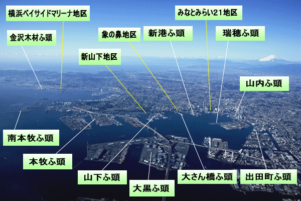
Yokohama Port
It is linked to the homepage of each wharf.
History of Yokohama Port
Yokohama Port opened as an international trading port on June 2, 1859 (Ansei 6).
While developing as a commercial port representing Japan with a huge consumption area of Tokyo and a vast hinterland that spreads beyond it, it has also played an important role as an industrial port based in coastal industrial areas such as the Keihin Industrial Zone. It has grown as a comprehensive port that combines these two characteristics.
To the "History of Yokohama Port" page
Ports of Yokohama Port
Inquiries to this page
Policy Coordination Division, Policy Coordination Division, Port and Harbor Bureau Policy Coordination Department
Telephone: 045-671-7165
Telephone: 045-671-7165
Fax: 045-671-7310
Email address: kw-seisaku@city.yokohama.lg.jp
Page ID: 253-497-785


