Here's the text.
Mizuho Wharf
Last Updated September 12, 2024

Mizuho Wharf
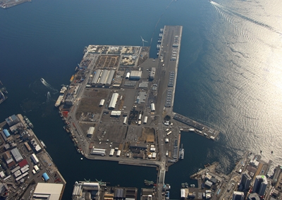
Mizuho Wharf started construction in 1925 (1925) and completed in 1945 (1945), but after the war, after receiving the requisition of the troops stationed, the U.S. military used it as a Japanese facility after the enforcement of the Peace Treaty. . Even today, 7 Bath (total length: 1,259m) is used by the U.S. Army in Japan and is commonly known as "North Pier".
In 1996 (1996), a new landfill was carried out on the adjacent land of "North Pier", and in March 2003 (2003), it was put into service as a new public wharf that mainly handles construction materials such as sand and gravel. did. The large windmill <wind power plant>, which can be seen from anywhere in Yokohama Port, is located at Mizuho Wharf. In addition, it also contains private wharf called Suzushige wharf.
- Related links (Yokohama Port Wharf Co., Ltd.) (outside site)
- Inquiry of ship information scheduled to enter and leave ports (external site)
- Inquiry of application information for use of sheds and cargo handling areas (outside site)
| Railway | 25-minute walk from Nakakido Station on the Keikyu Main Line |
|---|---|
| Car | About 5 minutes from Kanagawa 2-chome intersection on National Route 15 (Daiichi-Keihin National Highway) |
| Wharf name | Bath name | Quay extension (m) | Water depth (m) |
|---|---|---|---|
| Mizuho Wharf | Mizuho Wharf quay | 170 | 10.5 |
Inquiries to this page
Policy Coordination Division, Policy Coordination Division, Port and Harbor Bureau Policy Coordination Department
Telephone: 045-671-7165
Telephone: 045-671-7165
Fax: 045-671-7310
Email address: kw-seisaku@city.yokohama.lg.jp
Page ID: 427-567-473


