


- Yokohama-shi Top Page
- Municipal Government Information
- Public Relations, Public Information, News
- Public Relations and Publications
- Public Relations Printed Materials
- Public information Yokohama
- Public information Yokohama-shi version
- Discover Yokohama Aya
- February 2025 issue The river canal of Yokohama, the city seen in the photo-with reader present-
Here's the text.
February 2025 issue The river canal of Yokohama, the city seen in the photo-with reader present-
Yokohama with sea, port, greenery, history, region, people and various attractions. We will deliver the color of this city as "Yokohama Aya Discovery". This time, I would like to talk about the rivers and canals of Yokohama.
Last Updated February 1, 2025
As for the publication contents of "public information Yokohama" February, 2025 issue "Yokohama Aya discovery", please see link.
River canal of the city of Yokohama as seen in the photo
Kazuki Matsumoto, Researcher, Museum of Yokohama Urban History
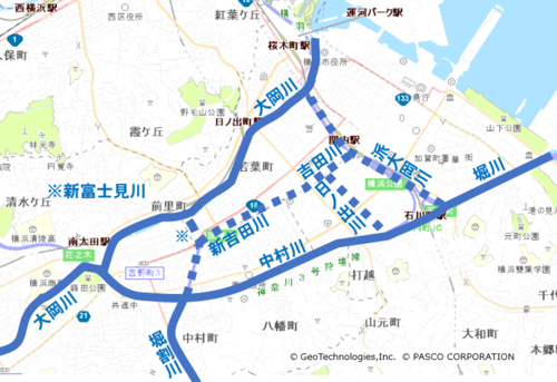
River location map (the dotted line is old river)
In recent years, urban rivers have been attracting attention as a hydrophilic space. In Yokohama, the promenades built on the Ookagawa River (Minami Ward and others) and the Ishizaki River (Nishi Ward) provide a place for people to relax. How did these urban rivers form in Yokohama and what kind of history did they follow? Let's take a look at the Yoshida River and Shinkichi Tagawa, which are now reclaimed and maintained as Odori Park (Naka Ward Minami Ward).
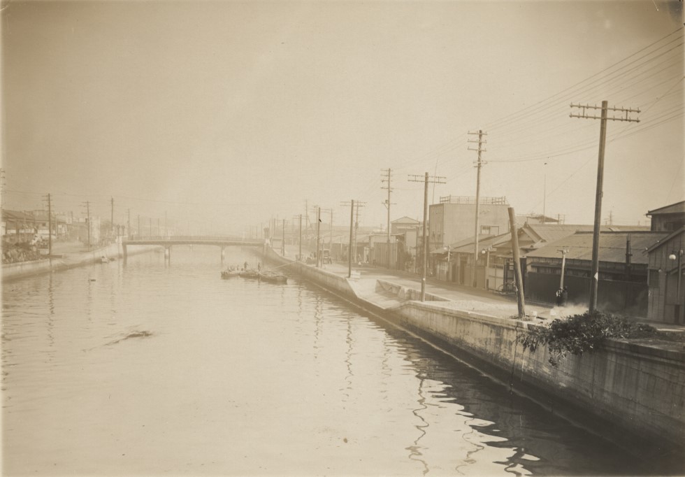
[Image 1] Shinkichi Tagawa (After completion of revetment work) Museum of Yokohama Urban History Kura (Photo by Sato)
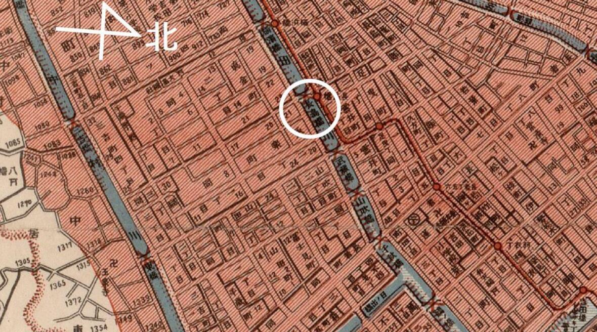
The photo in Image 1 was taken near Nagashima Bridge in Shinkichi Tagawa (currently near the middle of Isezaki-Chojamachi Station and Bandobashi Station). The Shinkichi Tagawa was excavated in 1896 (Meiji 29). In the Meiji era, in Yokohama, where the urban area on the Yoshidashinden side progressed, rivers were maintained and excavated, forming a river canal network along with the large Okagawa River, a natural river. Image 2 extracts the vicinity of Nagashima Bridge from a map called "Revised Yokohama City All Map" published in 1898 (Meiji 31). On the map, you can see Shinkichi Tagawa, Shinfuji Migawa, which connects Shinkichi Tagawa and Ookagawa, and Hinode River, which connects Yoshida River and Nakamurakawa. In addition, from the "Revised Yokohama City Map", it can be seen that the well-maintained river canal functioned as a water transport network. Image 3 extracts the area around the Ooka River from the "Revised Yokohama City Map". Around Yokohama Park, there was a food market for fresh food, and along the river there were wholesalers and wholesalers serving market-oriented products. There was also a steamship route to Yokosuka and Tokyo, and there was a departure / departure point for the regular route to Yokosuka, Sadakimaru Kisen Company in the port town.
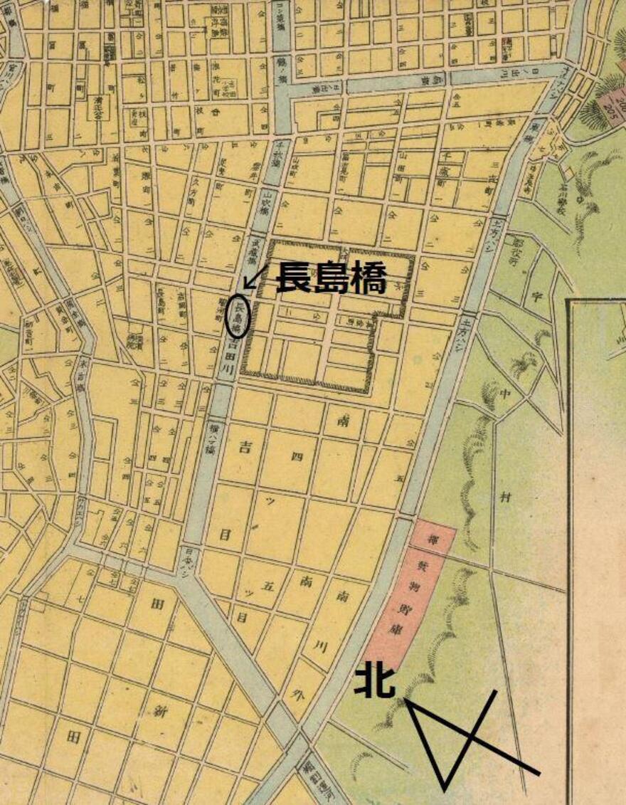
[Image 2] 1898 (Meiji 31) Yokohama Archives of History Kura in 1898, near Nagashimabashi
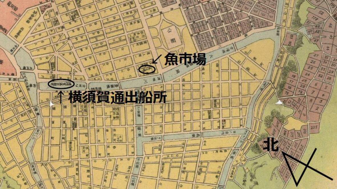
[Image 3] 1898 (Meiji 31) Collection of Yokohama Archives of History.
The river canal in Yokohama was severely damaged by the Great Kanto Earthquake that occurred in 1923 (Daisho 12). Image 4 is a map called "Yokohama Earth Map / Attached Daisho 12 Great Earthquake Fire Area", which describes the status of the damage caused by the Great Kanto Earthquake. As shown in Image 5, the cross mark shows damage to the bridge, and the red line drawn on the seawall shows the collapse and cracks of the seawall, but the bridges and seawalls of the Yoshida River and Shinkichi Tagawa, including the Nagashima Bridge, have been severely damaged by the earthquake. You can see that you have suffered.
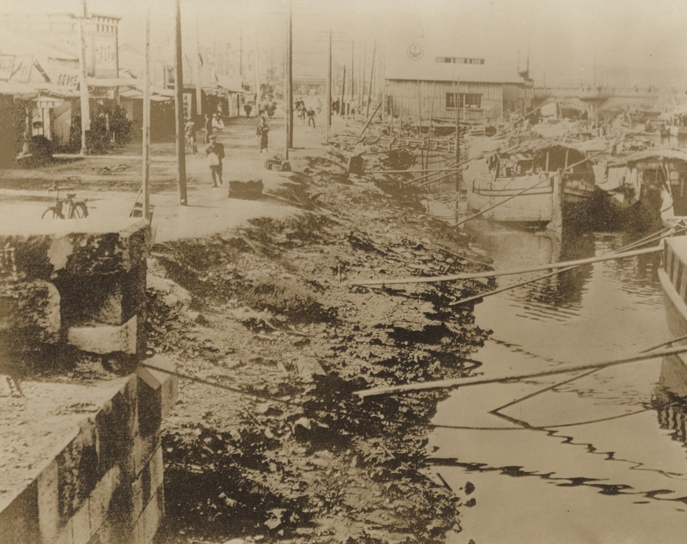
The magnitude of the damage can also be read from the photo. Image 6 shows the Ooka River after the Great Kanto Earthquake. The bridge at the back right of the image is Yoshidabashi Bridge. Even in the Ooka River, which borders the Yoshida River, there were many collapses and cracks of revetments due to the earthquake.
[Image 4] Yasuhiro Yasuoka, near Nagashima Bridge, Yasuhiro Yasuoka, 1923 (Daisho 12) Collection of Yokohama Archives of History
[Image 5] 1923 (Daisho 12), Yokohama Archives of History Kura, 1923 (Daisho 12)
[Image 6] Museum of Yokohama Urban History Kura, a former revetment of the Great Kanto Earthquake of the Ooka River, which collapsed in the Great Kanto region.
[Image 7] Yokohama City Hall, 1932 (Showa 7) Yokohama Archives of History Kura, 1932 (Showa 7)
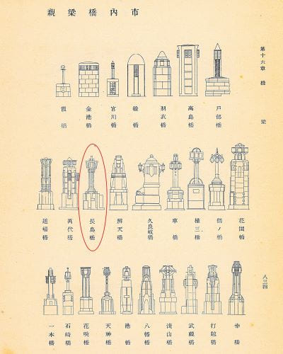
Reconstruction work on the damaged river canal will be promoted by the government and Yokohama City. The photo that conveys the situation is image 1 ahead. On the Nagashima Bridge in the center of the screen, you can see the main pillars with the design provided during the reconstruction work [Image 7]. The revetment has become a concrete retaining wall, and on both banks, there have been a landing site for boating. During this period, freight transportation by rail and car was also seen in Yokohama, but the photo shows that river canals were used as a transportation network.
Since the 1960s, Yokohama City has envisioned a large-scale urban plan ("Six Major Projects"). In the concept, river canals will be subject to development based on the high-speed railway plan (Yokohama Municipal Subway) and the expressway network plan (Tokyo Metropolitan Expressway). Image 8 shows a plan of the Yokohama Municipal Subway route. The blue line shows the river, and the red line shows the planned line of the subway. The subway was constructed in the form of reclaiming part of the Ooka River and the Yoshida River and Shinkichi Tagawa River, and Odori Park was built on the ground. In this construction, the bridges on the Yoshida River and Shinyoshida River, including Nagashima Bridge, have disappeared, but traces of the bridge can be seen on the relief installed at Isezaki-Chojamachi Station [Image 9]. The relief established in 1981 (Showa 56) tells us that the Odori Park, which is still a place for citizens to relax, was once a canal familiar to the citizens.
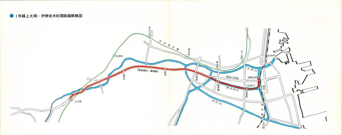
[Image 8] “Schematic Map of Route 1 between Kamiooka and Isezakicho” (“New Citizens' Subway”) City of Yokohama, Transportation Bureau High-speed Railway Construction Department, 1967, Museum of Yokohama Urban History Kura, Ltd.
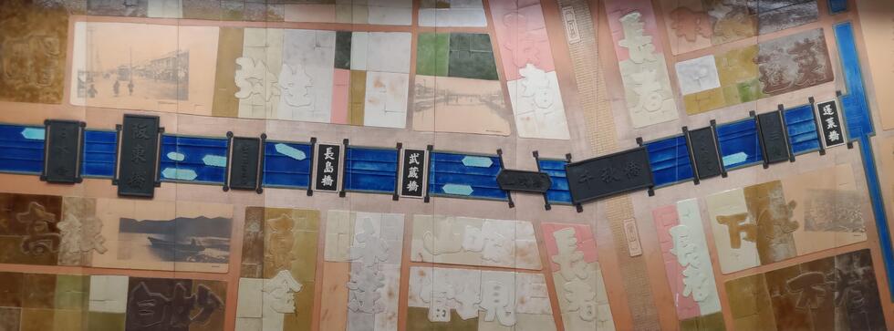
[Image 9] Reef (part) installed at Isezaki-Chojamachi Station December 12, 2024 (Reiwa 6) Photographed by the author
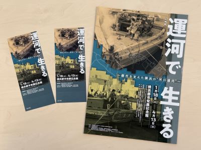
Museum of Yokohama Urban History Exhibition "Living in Canals: The River Canal in Yokohama that Supported the City"
Period From Saturday, January 18, 2025 to Sunday, April 13, 2025 (Reiwa 7) ※
※ Closed days: Monday [However, it opens on February 24 and closes on Tuesday, February 25]
Opening hours from 9:30 to 17:00 (ticket sales until 16:30)
Venue Yokohama City Development Memorial Hall 18 Nihon Odori, Naka-ku, Yokohama City (a short walk from Nihon Odori Avenue Station in Minato Mirai Line)
Please check the viewing fee and other links (outside site).
Special exhibition "Living in Canals-The River Canal in Yokohama that Supported the City-" Notice of Residents' Day
If you live in the 4 wards related to the special exhibition, you can view it free of charge by presenting a certificate that shows your place of residence on the following schedule.
Nishi Ward: February 26, Isogo Ward: March 5, Naka Ward: March 19, Minami Ward: March 26 (both Wednesday)
Reader present [Deadline for Sunday, March 2, 2025]
Thank you for always seeing "Public Information Yokohama" and "Yokohama Aya Discovery". 5 groups of 10 people will receive an invitation ticket for the special exhibition “Living in the Canal:“ River Canal ” in Yokohama, which supported the city,” which is being held in Museum of Yokohama Urban History. If you wish, please refer to the following six items. ※Please specify and apply by postcard (to Yokohama City Hall Policy and Management Bureau, 6-50-10 Honcho, Naka-ku, Yokohama 231-0005) or e-mail (sss-saihakken@city.yokohama.lg.jp). The deadline must arrive on Sunday, March 2, 2025.
※ 1.Postal code, 2. Address, 3. Name, 4. Impression, 5. I would like to read, 6. "I would like to present a February issue"
The winner's announcement will be returned by sending the prize. In addition, the personal information you receive will not be used for any purpose other than sending prizes.
Public Relations Section, Policy Management Bureau, Yokohama City Hall TEL: 045‐671-2331 FAX: 045‐661-2351
Inquiries to this page
Public Relations Section, City Promotion Promotion Office, Policy Management Bureau
Telephone: 045-671-2331
Telephone: 045-671-2331
Fax: 045-661-2351
Email address: ss-koho@city.yokohama.lg.jp
Page ID: 657-706-235


