Here's the text.
C-103: Area around Hongodai Station
City planning decision date: July 5, 2016
Last Updated December 9, 2022
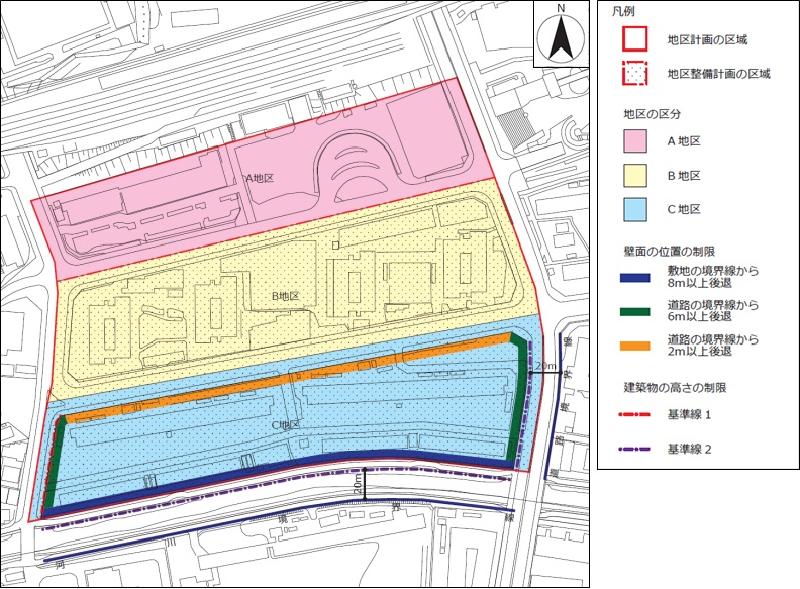
 Plan drawing (division of district, restriction of position of wall surface, restriction of height of building)
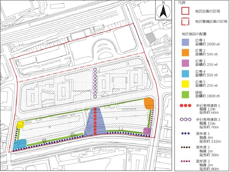
 Plan drawing (location and scale of district facilities)
| Name | Around Hongodai Station District Planning | |
|---|---|---|
| Position | 1-chome Kosugegaya, Sakae-ku and 2-chome Kosugegaya, Sakae-ku | |
| Area | About 7.3ha | |
| Targets of District Planning | This area is a highly convenient area located in front of Hongodai Station on the JR Negishi Line. On the south side of the area, it borders the Itachi River. The Yokohama City Urban Planning Master Plan overall plan states that the area around the railway station in the suburbs is a valuable land for improving the convenience of citizens' lives, and for this reason, around the station where sufficient infrastructure such as the station square is maintained, It is said that land use will be properly advanced. In addition, while focusing on forming a unique and attractive district according to the resources and characteristics of the area for living bases around the station, working, enjoying, buying, etc. as a unique living base The company plans to accumulate and enhance the functions according to the size of the area of users around the station. According to the Sakae Ward Plan, Yokohama City Planning Master Plan, land use policy states that the area around Hongodai Station will be integrated with commercial and business functions that take advantage of local characteristics and coexist with middle- and high-rise housing. In addition, the policy of town development stipulates revitalization around Hongodai Station as a base for inhabitants of the ward, and enhancement of functions as a local community base and welfare base around Hongodai Station. In the area around Hongodai Station, the concept of town development around the area is to create a charm unique to Hongodai that is different from the vicinity of the neighboring station, enhance childcare facilities, enhance life support facilities for the elderly, form an axis connecting the Itagawa and station square, and activate the station square. Enhancement of shopping environments and cafes are required. Based on these, this district plan secures the unity of the station square and the station square park and the continuity of the station square and the Itta River, and guides facilities that promote the creation of liveliness appropriate for the station square and local exchange By doing so, we aim to create a good, comfortable and attractive environment suitable for the center of the city. |
|
| Ward Areas No 1. Bill ・ Opening Departure Oh Bi Hoping All Ni Seki S L Sir Needle |
Land Use Policy | We divide area of this district plan three and establish policy of land use as follows each. 1 Area A In addition to planning the location of commercial facilities and middle- and high-rise houses, an attractive station space will be formed by the integrated redevelopment of the station square and the station square park. District 2 B The location of commercial facilities and middle- and high-rise houses will be planned to create a lively area along the pedestrian passage connecting the station square and the Itagawa promenade. 3 District C In order to create a continuous buzz from the station square, a plaza integrated with the pedestrian passage connecting the station square and the Itagawa promenade will be arranged. In addition, in order to enhance the convenience of the area around the station, commercial facilities, exchange facilities, welfare facilities, etc. that contribute to the area will be introduced in the low-rise area, and the location of middle- and high-rise housing for multiple generations will be planned. |
| Policy for the development of district facilities | In order to improve the attractiveness of the area and improve the convenience of pedestrians, we will maintain a pedestrian passage connecting the station square and the Itagawa promenade. In district C, we maintain space where green is appropriately arranged and citizen can rest and open space which secured unity of passage for pedestrian. In addition, a plaza with various functions, such as a playground for children, a place for health promotion, and a place for temporary evacuation in the event of a disaster, will be developed to provide a space where local residents and other facility users in the block can relax. Furthermore, in order to form a good urban environment, green spaces will be developed around the block. The promenade will be integrated with the parallel green space to create a rich pedestrian space. |
|
| Policy for maintenance of buildings, etc. | Create the bustle of the low-rise part facing the pedestrian passage of the district facility, and consider the environment, such as promoting resource saving and energy saving when planning buildings. About district C, we assume placement of building conscious that gaze goes out from station square direction to Itachi River and, in order to guide use contributing to area, limit use of building, building coverage ratio The maximum limit, the minimum site area of the building, the limit of the position of the wall, the maximum height of the building, the limit of the height of the building, the restriction of the form design of the building, and the minimum of the greening rate of the building. |
|
| Greening Policy | Promote greening integrated with the cityscape to form an attractive cityscape as a base for inhabitants of a ward. In particular, we will focus on greening in places where the gaze gathers and where traffic lines intersect. Along the Itachi River, we will promote quantitative greening using tree species etc. in harmony with the cityscape in order to create a cityscape that feels the four seasons that makes use of the natural environment. |
|
District maintenance plan |
||||
|---|---|---|---|---|
Placement and scale of district facilities |
Square 1 |
Approximately 2,000㎡ |
||
Square 2 |
Approx. 500㎡ |
|||
Square 3 |
Approximately 250㎡ |
|||
Square 4 |
Approx. 500㎡ |
|||
Square 5 |
Approximately 250㎡ |
|||
A passage for pedestrians 1 |
Width 12.0m extension about 60m |
|||
A passage for pedestrians 2 |
Width 12.0m extension about 70m |
|||
Promenade 1 |
Width 4.0m extension about 310m |
|||
Promenade 2 |
Width 2.0m extension about 30m |
|||
Promenade 3 |
Width 2.0m extension about 40m |
|||
Green space |
Approx. 1,800㎡ |
|||
Matters related to buildings, etc. |
Classification of district | Name |
District C |
|
Area |
About 2.7ha |
|||
Restrictions on the use of buildings |
Buildings listed in the following items shall not be constructed. |
|||
Maximum building coverage ratio |
6/10 |
|||
Minimum site area of buildings |
7,000㎡ |
|||
Restrictions on the position of the wall |
The outer wall of the building or the surface of the pillar in place of this shall not be built beyond the limit of the position of the wall shown in the plan drawing. |
|||
Maximum height of buildings |
1 The height of the building must not exceed 45m. |
|||
Restrictions on form design of buildings, etc. |
1 The form design of the building shall conform to the following matters in order to consider the landscape harmony to the surroundings. |
|||
Minimum of greening rate of buildings |
15/100 |
|||
≪About report of act in area of city planning≫
・A District does not need to submit a report because the district maintenance plan has not been established.
◆Since restrictions on forms or designs such as buildings in this district are stipulated in the City Planning Ordinance, procedures for certification of form designs are required in addition to notification.
◆Because "minimum greening rate of building" of this district is stipulated in the city planning regulations, procedures such as certificates about conformity of tree planting rate may be necessary before report.
Inquiries to this page
Urban Development Bureau Regional Town Development Department Regional Town Development Division
Telephone: 045-671-2667
Telephone: 045-671-2667
Fax: 045-663-8641
Email address: tb-chiikimachika@city.yokohama.lg.jp
Page ID: 139-542-011


