


現在位置
Last Updated December 9, 2022
Here's the text.
C-044: Sakae Shonan Katsuradai district
City planning decision: May 25, 2001
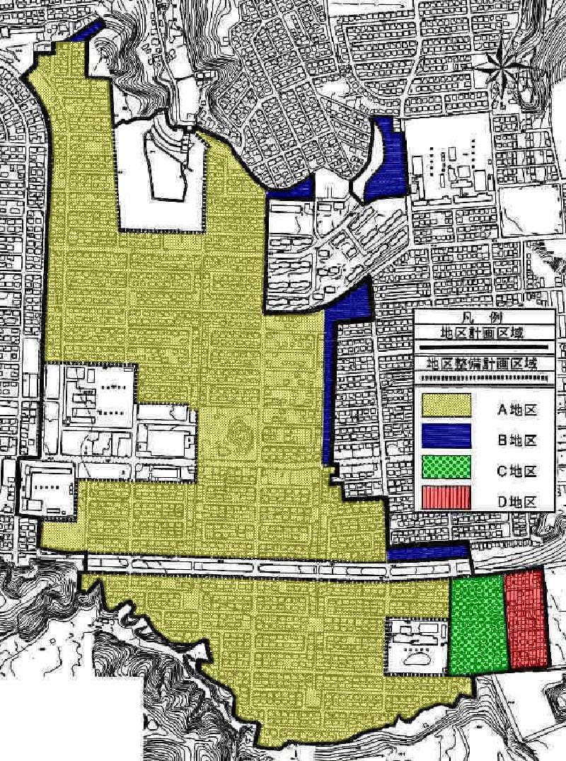
Plan drawing
| Name | Sakae Shonan Katsuradai district district plan | |
|---|---|---|
| Position | Inuyama-cho, Sakae-ku, Yokohama-shi, Katsuradaikita, Katsuradainaka, Katsuradainishi 1-chome, Katsuradainishi 2-chome, Katsuradaihigashi, Katsuradai Minami 1-chome, Katsuradai Minami 2-chome, Kamigo-cho, Kameicho and Nakanomachi | |
| Area | Approx. 68.6ha | |
| Ward Areas No 1. Bill ・ Opening Departure Oh Bi Hoping All No Sir Needle |
Targets of District Planning | This area is located in the southeastern part of Sakae Ward, on a hill adjacent to the city border with Kamakura City, and is a detached residential area developed in the 1940s and 1950s to maintain a good living environment. More than 20 years have passed since the development, and it is about to reach the time of rebuilding and extension. The purpose of this district plan is to maintain and preserve the living environment and to form a lush cityscape by properly guiding architectural activities while responding to changes in the lives of residents. |
| Land Use Policy | In District A, District B, District C and District D, we plan the location of low-rise houses mainly composed of detached houses, consider a good living environment, prevent deterioration of the living environment due to changes in the ground surface and unused We strive for proper maintenance of land. In the central part of the district where Katsuradainaka School, Katsuradai Community Care Plaza, etc. are installed, we plan the location of convenience facilities such as stores and public utilities, etc., and consider the environment of the surrounding urban area when building. In the future utilization of the retarding ponds, we will strive to harmonize with low-rise houses. |
|
| Policy for maintenance of buildings, etc. | In A district, B district, C district and D district, in order to maintain and maintain a good environment mainly for detached houses, restrictions on the use of buildings and the maximum ratio of the total area of buildings to the site area Determine the maximum ratio of the building area to the site area of the building, and the minimum floor area of the building. | |
| Greening Policy | Active greening of the site will be planned so that a moist cityscape will be formed in District A, District B, District C and District D. | |
| District maintenance plan | ||||||
|---|---|---|---|---|---|---|
| Construction Construction Goods Etc. Ni Seki S L A matter Section |
Classification of district | Name | District A | District B | District C | District D |
| Area | About 48.2ha | About 2.7ha | About 2.1ha | About 1.5 ha | ||
| Restrictions on the use of buildings | Buildings other than those listed below must not be built.
|
Buildings other than those listed below must not be built.
|
||||
| Maximum ratio of total building area to site area | 8/10 | 6/10 | ||||
| Maximum ratio of building area to site area of building | 4/10 | 5/10 | 3/10 | |||
| However, for buildings that fall under Article 53, Paragraph 3, Item 2 of the Building Standards Act (Act No. 201 of 1950), 1/10 shall be added. | ―― | |||||
| Minimum site area of buildings | 165㎡ | |||||
Provided, however, that this shall not apply to land that falls under any of the following.
|
||||||
| Restrictions on the position of the wall | The distance from the outer wall of the building or the surface of the pillar in place of this to the boundary of the front road and the boundary of the adjacent land shall be 1m or more. Provided, however, that this shall not apply if the building or the part of the building at a distance less than the limit of this distance falls under any of the following.
|
―― | ||||
| Maximum height of buildings |
|
|
||||
| Restrictions on forms or designs of buildings, etc. | The colors of the roof and outer wall of the building shall be in harmony with the surrounding landscape. | |||||
◆A part of the Sakae Shonan Katsuradai district city planning area has local town development rules certified by Yokohama City.
For more information, please visit the following page.
Shonan Katsuradai Town Development Guidelines
In addition, about procedure of local town development rule, please see the next page.
Discussion and notification of local town development rules
Inquiries to this page
Urban Development Bureau Regional Town Development Department Regional Town Development Division
Telephone: 045-671-2667
Telephone: 045-671-2667
Fax: 045-663-8641
Email address: tb-chiikimachika@city.yokohama.jp
Page ID: 414-459-587


