


Here's the text.
C-061: Sakae Kosugaya district
City planning decision: November 5, 2003
Last Updated December 9, 2022
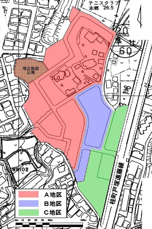
Plan drawing
| Name | Sakae Kosugaya District Planning | |
|---|---|---|
| Position | 4-chome Kosugegaya, Sakae-ku, Yokohama and 1-chome Hongodai | |
| Area | About 2.7ha | |
| Ward Areas No 1. Bill ・ Opening Departure Oh Bi Hoping All No Sir Needle |
Targets of District Planning | The goal of this district plan is to form, maintain and maintain a good cityscape and living environment based on the following maintenance policies while maintaining comfort and convenience as a residential area in harmony with the surrounding area. I do. |
| Land Use Policy | The district is divided into areas from areas that promote the convenience of the surrounding urban area adjacent to the city planning road Katsuracho Tozuka Endo Line to areas that consider the surrounding living environment, such as the adjacent Hongodai Residential Area Building Agreement Area. Induce land use according to each policy.
|
|
| Policy for the development of district facilities | The park will be developed in the northwestern part of the district. | |
| Policy for maintenance of buildings, etc. | In order to form a good living environment according to the characteristics of each district, restrictions on the use of the building, the maximum floor area ratio of the building, the maximum building coverage ratio, the minimum floor area of the building, The limit on the position of the wall, the maximum height of the building, the restrictions on the form or design of the building, and the restrictions on the structure of the fence or fence. | |
| Greening Policy | We plan active greening such as site of building or park to form good environment. | |
| District maintenance plan | |||||
|---|---|---|---|---|---|
| Placement and scale of district facilities | Park | Approximately 1,200㎡ | |||
| Construction Construction Goods Etc. Ni Seki S L A matter Section |
Classification of district | Name | District A | District B | District C |
| Area | Approx. 1.8ha | Approx. 0.4ha | Approx. 0.5 ha | ||
| Restrictions on the use of buildings | Buildings other than the following buildings must not be built.
|
The following buildings must not be constructed.
|
|||
| Maximum floor area ratio of buildings | - | 15/10 | - | ||
| Maximum building coverage ratio | - | 5/10 (6/10 for those that fall under Article 53, Paragraph 3, Item 2 of the Building Standards Act (Act No. 201 of 1950)) | - | ||
| Minimum site area of buildings | The site area of the building shall be more than 150m2 and the area obtained by multiplying the number of dwelling units by 70m2. | The site area of the building shall be more than 150m2 and the area obtained by multiplying the number of dwelling units by 35m2. | The site area of the building shall be 150 m2 or more. | ||
Provided, however, that this shall not apply to land that falls under any of the following.
|
|||||
| Restrictions on the position of the wall | The distance from the outer wall of the building or the surface of the pillar in place of this to the boundary of the front road (excluding the city planning road Katsuracho Tozuka Endo Line) shall be 1.0 m or more, and the distance to the adjacent land boundary line shall be 0.6 m or more. I do. But it is not this limit when building or part of building in distance less than limit of this distance corresponds to any of the following.
|
||||
| Maximum height of buildings | - |
|
- | ||
| Restrictions on forms or designs of buildings, etc. |
|
||||
| Restrictions on the structure of a fence or fence | The structure of the fence or fence facing the road shall have hedges, fences and similar openness. However, this excludes fence foundations, gateposts, gates and the like. | ||||
Inquiries to this page
Urban Development Bureau Regional Town Development Department Regional Town Development Division
Telephone: 045-671-2667
Telephone: 045-671-2667
Fax: 045-663-8641
Email address: tb-chiikimachika@city.yokohama.lg.jp
Page ID: 435-296-887


