Last Updated December 9, 2022
Here's the text.
C-063: Sakae Kasama area
City planning decision: January 5, 2004

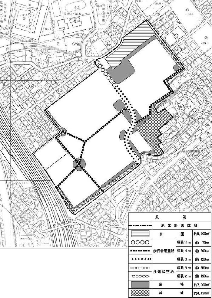
Plan drawings (district facilities)

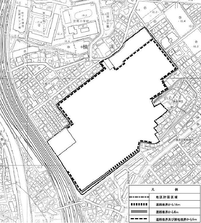
Plan drawing (restriction of wall position)

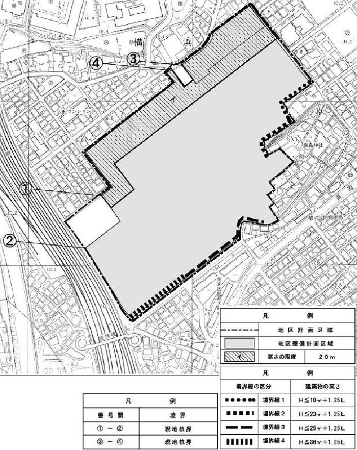
Plan drawing (maximum height of building)
| Name | Sakae Kasama District District Planning | |
|---|---|---|
| Position | 1-chome Kasama and 3-chome Kasama, Sakae-ku, Yokohama | |
| Area | About 9.4ha | |
| Ward Areas No 1. Bill ・ Opening Departure Oh Bi Hoping All No Sir Needle |
Targets of District Planning | The Sakae Kasama area is located about 600m north of Ofuna Station on the JR Tokaido Line, and is surrounded by city planning roads 3.3.17 Shimonagaya Ofuna Line, railway, city planning roads 3.4.3 ring Route 4.4.3 It is an area. In this district plan, we introduce functions such as houses with relocation of factory and plan maintenance of district facilities contributing to neighboring areas such as open space, pedestrian space, sidewalk-like open space and plan formation of good living environment The goal is to |
| Land Use Policy | We plan location such as urban-type houses and form comfortable and high-quality living space by maintenance of urban infrastructure facilities such as open spaces and pedestrian spaces. | |
| Policy for the development of district facilities | We maintain necessary parks, open spaces, etc. in the district and form a comfortable pedestrian network with pedestrian passages, sidewalk-like open spaces, and open spaces related to the existing road network. In addition, the existing green space in conservation will be constructed in consideration of the surrounding environment. | |
| Policy for maintenance of buildings, etc. | Consider the impact on the surrounding environment, such as sunshine, ventilation, and landscape. In addition, in order to plan locations such as urban houses, restrictions on the use of buildings, restrictions on the position of walls, the maximum height of buildings, restrictions on forms or designs such as buildings, and structures of fences or fences Determine restrictions. | |
| Greening Policy | In order to form a lush and moist cityscape, we will preserve the natural green space in the district and actively promote greening on the site. | |
| District maintenance plan | ||||||||||||
|---|---|---|---|---|---|---|---|---|---|---|---|---|
| Placement and scale of district facilities | Park | Approx. 5,300㎡ | ||||||||||
| Aisles for pedestrians | Width 4.0m extension approximately 690m Width 3.0m extension about 420m Width 11.0m extension about 70m |
|||||||||||
| Sidewalk-like open space | Width: 3.0m extension: 250m Width 2.0m extension about 190m |
|||||||||||
| Open space | Approx. 7,000㎡ | |||||||||||
| Green space | Approx. 4,120㎡ | |||||||||||
| Construction Construction Goods Etc. Ni Seki S L A matter Section |
Restrictions on the use of buildings | Buildings listed in the following items shall not be constructed.
|
||||||||||
| Restrictions on the position of the wall | The outer wall of the building or the surface of the pillar in place of this shall not be built beyond the limit of the position of the wall shown in the plan drawing. But it is not this limit when part of building or building corresponds to any of the following.
|
|||||||||||
| Maximum height of buildings |
|
|||||||||||
| Restrictions on forms or designs of buildings, etc. | The roof and outer wall of the building shall be in harmony with the surrounding cityscape and shall be considered in color and design. | |||||||||||
| Restrictions on the structure of a fence or fence | The structure of the fence or fence facing the road shall have hedges, fences and similar openness. | |||||||||||
Inquiries to this page
Urban Development Bureau Regional Town Development Department Regional Town Development Division
Telephone: 045-671-2667
Telephone: 045-671-2667
Fax: 045-663-8641
Email address: tb-chiikimachika@city.yokohama.lg.jp
Page ID: 862-088-011


