


Here's the text.
C-025: Sakae Nagaodai district
City planning decision: July 14, 1995
Last Updated December 9, 2022
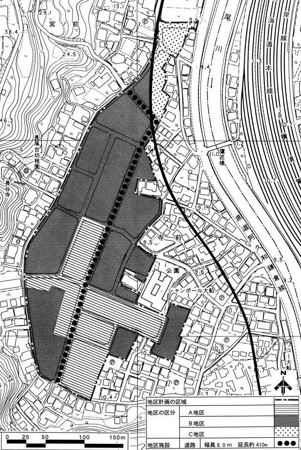
Plan drawing
Name |
Sakae Nagaodai District Planning | |
|---|---|---|
| Position | Nagaodaicho, Sakae-ku, Yokohama-shi | |
| Area | Approx. 4.9ha | |
| Ward Areas No 1. Bill ・ Opening Departure Oh Bi Hoping All No Sir Needle |
Targets of District Planning | This area is located at the western end of Sakae Ward, approximately 0.8 km north of Ofuna Station on the JR Tokaido Main Line, and is a flat area with farmland sandwiched between the Kashio River and the urbanization control area. In addition, it is a district that is positioned as a "suburban residential area" in the Yumehama 2010 Plan and aims to form a residential area with a good environment. This district plan forms a good environment and a lively residential area while maintaining harmony with the surrounding urban area in areas where infrastructure maintenance such as roads and parks is carried out by land readjustment projects, and maintains the environment. The goal is to maintain. |
| Land Use Policy | Divide three districts and guide land use according to their respective policies. District A The location of low-rise houses mainly in detached houses will be planned. District B The location of detached houses and low-rise houses mainly in apartment. District C Aiming to locate middle- and high-rise houses mainly in apartment. |
|
| Policy for the development of district facilities | Development of arterial roads in the district that runs north and south through the district. | |
| Policy for maintenance of buildings, etc. | In order to form a good living environment according to the characteristics of each district, restrictions on the use of buildings, minimum floor area of buildings, restrictions on the position of walls, restrictions on forms or designs of buildings, etc. Define the restrictions on the structure of fences or fences. In addition, in apartment houses, we install parking lot corresponding to the number of dwelling units. |
|
| Greening Policy | We plan active greening such as site of building or park to form good environment. | |
| District maintenance plan | |||||
|---|---|---|---|---|---|
| Placement and scale of district facilities | Roads | Width: 8.0m, length: 410m | |||
| Construction Construction Goods Etc. Ni Seki S L A matter Section |
Classification of district | Name | District A | District B | District C |
| Area | Approx. 1.4ha | About 3.2ha | Approx. 0.3ha | ||
| Restrictions on the use of buildings | Buildings other than the buildings listed in the following items must not be built. 1 Housing 2 Houses that also serve as offices, stores, and other similar uses 3 apartment houses 4 Schools, libraries, and the like 5 sergeant dispatch offices, public telephone offices, and similar buildings necessary for the public interest 6 Those attached to the buildings in each of the preceding items |
The buildings listed in the following items shall not be constructed. 1 Shrines, temples, churches and the like 2 Public baths |
Buildings listed in the following items shall not be constructed. 1 Shrines, temples, churches and the like 2 Public baths 3 Factories (excluding those attached to stores, restaurants and other buildings used for similar purposes) |
||
| Minimum site area of buildings | The site area of the building shall be more than 150m2 and the area obtained by multiplying the number of dwelling units by 75m2. | The site area of the building shall be more than 150m2 and the area obtained by multiplying the number of dwelling units by 50m2. | |||
| Provided, however, that this shall not apply to land that falls under any of the following. 1 Land used as a site for public toilets, police station offices and other similar buildings necessary for the public interest 2 Land used as a site for buildings to be shared convenience by libraries, management offices and other similar residents When the minimum site area of 3 buildings is set, land that is actually used as a site of a building and that does not conform to the provisions of the district, uses all of them as one site. 4 For land that has been designated as a replacement land or a temporary replacement lot pursuant to the provisions of the Land Readjustment Act, and that does not conform to the provisions of the district, use all of it as one site based on ownership and other rights . |
|||||
| Restrictions on the position of the wall | The distance from the outer wall of the building or the surface of the pillar in place of this to the boundary of the front road shall be 1.0 m or more, and the distance to the adjacent land boundary shall be 0.6 m or more. Provided, however, that this shall not apply if the building or part of the building at a distance less than the limit of this distance falls under any of the following. 1 The total length of the center line of the outer wall or pillar in place of it is 3m or less 2 Used for storerooms and other similar uses (excluding car garages), with a height of 2.3 m or less and a total floor area of 5 m2 or less 3 Used for car garages and whose height of eaves is 2.3m or less |
||||
| Restrictions on forms or designs of buildings, etc. | 1 The colors of the roof, outer wall and outdoor advertising materials of the building shall not be stimulating. 2 The size and shape of outdoor advertising materials shall be considered in consideration of the landscape. |
||||
| Restrictions on the structure of a fence or fence | The structure of the fence or fence facing the road shall have hedges, fences and similar openness. However, this excludes gateposts and similar items. | ||||
Inquiries to this page
Urban Development Bureau Regional Town Development Department Regional Town Development Division
Telephone: 045-671-2667
Telephone: 045-671-2667
Fax: 045-663-8641
Email address: tb-chiikimachika@city.yokohama.lg.jp
Page ID: 319-357-461


