


Here's the text.
Umeda River
Last Updated March 23, 2021
The Umeda River is a tributary of the Tsurumi River, a first-class river. It flows northeast around Miho-cho in Midori Ward and joins the Onda River in Niiharucho.
Since 1978, the junction of the upstream Takebashi-Onda River has been drastically renovated. Urban Ogawa River Rehabilitation Subsidy Program (currently moved to urban infrastructure river rehabilitation project) Based on this, it was implemented with the assistance of the national and prefectural governments.
The upper and middle left banks are designated as urbanization control areas, and there are "Miho Citizen's Forest", "Tsuzuki Nature Park" and "Shinji Forest" that make use of natural terrain, and are used for paddy fields and fields. I am. From the middle to downstream, residential areas can be seen, but almost natural rivers are in fields and forests.
More detailed information about the Umeda River is also introduced on the page called "River Story". Check it out!
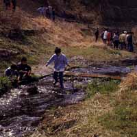
Introduction of waterside
Umeda River Waterfront Plaza

The right bank, upstream from Shinmei Bridge, borders Miho Nusuzaka Park, which has a coppice forest. On the left bank, the rural scenery of Tando, including farmland, spreads out. River maintenance is being promoted to integrate with Miho Nenjuzaka Park, and a friendly river is being created. On the old riverbed, etc., the gentle slope protection shore of Toba is made so that the meandering rivers, pools, and riverbanks are naturally created. In addition, a low waterway with a depth of 30 cm and a slope work are provided to consider the natural environment and ecosystem, such as restoration of vegetation and habitat of living organisms.
Data
| Management category | First-class river in Tsurumi River |
|---|---|
| Management extension | 2,220m |
Inquiries to this page
River Planning Division, River Department, Sewerage River Bureau
Telephone: 045-671-4215
Telephone: 045-671-4215
Fax: 045-651-0715
Email address: gk-kasenkikaku@city.yokohama.lg.jp
Page ID: 845-851-766


