


Here's the text.
Irie River
Last Updated March 23, 2021
The Irie River flows west from the vicinity of Higashi Terao, Tsurumi-ku, and changes to the south in parallel with the JR Yokohama Line near Nishi Terao, Kanagawa-ku, and passes along the Oguchi Shopping Street into Koyasu-dori, Kanagawa-ku. Divided into Yokohama Port.
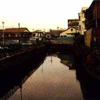
The middle and lower reaches are masonry seawalls, where private houses are dense on both sides, showing the appearance of rivers in the city area. Fish such as mullets are observed downstream due to the tide, and nearby there is the original scenery of downtown Yokohama such as Oguchi Shopping Street.
The old coastline retains the remnants of Ryoshimachi. Before the war, it prospered as a fishing port for Edo-mae haze and eel fishing, but now it is mainly used as a base for recreational fishing boats, and fishing boats and pleasure boats have been trapped.
The canal at the mouth is 80m downstream from Irie Bridge on National Route 15 and is divided into the first and second rivers. This is the estuary before landfill, and there are unloading facilities on both banks. Beyond that, there is the Koyasu lamp exit on the Metropolitan Expressway Kanagawa Route 1 Yokoha Line elevated, and beyond it is reclaimed.
Data
| Management category | Irie River water system mutatis mutandis river |
|---|---|
| Management extension | 2,390m |
Inquiries to this page
River Planning Division, River Department, Sewerage River Bureau
Telephone: 045-671-4215
Telephone: 045-671-4215
Fax: 045-651-0715
Email address: gk-kasenkikaku@city.yokohama.lg.jp
Page ID: 798-985-876


