


Here's the text.
Miyakawa
Last Updated March 23, 2021
Miyakawa originates from the vicinity of Kamariya-cho, Kanazawa-ku, heads east, joins the right and left tributaries on the way, and joins the Yatsu River in the low flat area and pours into Hiragata Bay.
Near the upstream area, large-scale development has progressed due to good transportation, and it has been remarkably urbanized.However, there are "Kanazawa Citizen's Forest" and "Kanazawa Nature Park" nearby, which is the greenest in Yokohama city. I'm in contact with the area. The middle stream is parallel to the prefectural road Mudgame Kamariya Line, with residential areas on the right bank and commercial facilities on the left bank. From Kanazawa Bunko Station downstream to National Route 16, public, cultural and commercial facilities are concentrated, making it the center of the ward.
The total length of 2.04 km from the junction with the Hiragata Bay Kawaguchi Sakaigawa to the junction of the right tributary is the Urban Ogawa River Rehabilitation Project (currently shifted to the Urban Infrastructure River Rehabilitation Project) We're making improvements.
Introduction of waterside
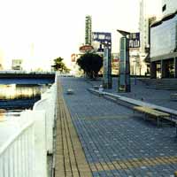
A river that has penetrated into the city
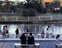
At a large-scale commercial facility on the right bank of the lower reaches of Akitsuki Bridge, the public space of the commercial facility and the passage for river management are integrated, benches and lighting are installed, and it is popular as a place to relax.
In addition, there are high-rise houses on the right bank from Akitsuki Bridge to Okawa Railway Bridge, but here, high-rise houses and river management passages are integrated and planted.
Data
| Management category | Miyakawa Water System Second Class River |
|---|---|
| Management extension | 2,040m |
Inquiries to this page
River Planning Division, River Department, Sewerage River Bureau
Telephone: 045-671-4215
Telephone: 045-671-4215
Fax: 045-651-0715
Email address: gk-kasenkikaku@city.yokohama.lg.jp
Page ID: 407-825-133


