


- Yokohama-shi Top Page
- Living and Procedures
- Community Development and Environment
- Rivers and sewers
- Rivers
- Introduction of rivers, etc.
- List of rivers flowing through Yokohama City
Here's the text.
List of rivers flowing through Yokohama City
You can see the list of rivers flowing through Yokohama City and the administrator.
Last Updated June 10, 2024
- River Map of Yokohama City
- River list (by water system)
- River extension and management category
- "The River in Yokohama" Video and Pamphlet
Rivers flowing through Yokohama City
Yokohama City has a total of 56 rivers, including 9 first-class rivers, 24 second-class rivers, and 23 mutatis mutandis rivers. The total length is about 215 km.
Type of river
"First-class rivers" are rivers that are particularly important in the national land conservation or the national economy, and are designated by the Minister of Land, Infrastructure, Transport and Tourism.
"Second-class rivers" are rivers other than first-class rivers that have an important relationship with public interests, and mean rivers designated by the prefectural governor.
"Applicable rivers" means rivers designated by the mayor as important from the viewpoint of public nature, except for first-class rivers and second-class rivers.
Other than these three types are referred to as "ordinary rivers", "general sewers" or "waterways".
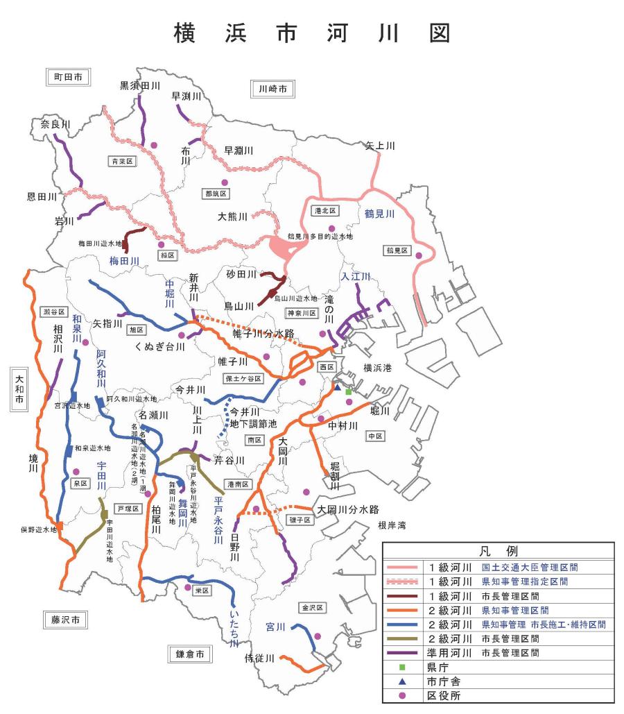
River Map of Yokohama City (Figures of rivers flowing through Yokohama City)
River list (by water system)
In rivers, small rivers merge from the upstream, and as they gradually head to the sea while repeating this merger, they become large rivers. The unit that combines these groups of rivers is called "water system".
The rivers flowing through Yokohama can be divided into Tsurumi River water system, Katabira River water system, Ookagawa water system, Sakaigawa water system and other rivers.
Click on the river name to see the river management categories and extensions.
※Even the same river may be divided into first-class rivers and mutatis mutandis rivers, second-class rivers and mutatis mutandis rivers.
(1)Tsurumi River water system
・First-class rivers: Tsurumi River, Onda River, Umeda River, Kamoi River, Okuma River, Toriyama River, Sunada River, Hayabuchi River, Yagami River
・Mutatis mutandis river: Kurosuda River, Nara River, Iwakawa River, Hayabuchi River, Fukawa River
(2)Katabira River Water System
・Second-class rivers: Katabira River, Naka-Horikawa, Ima Igawa, Ishizaki, Aratama River, Saiwai River and Katabira River Channels
・Mutatis mutandis river: Shin-Igawa, Kunugidai River, Yasashi River
(3)Ookagawa River System
・Second-class rivers: Ookagawa, Hino River, Nakamurakawa, Horikawa, Hiwari River, Ookagawa Branch Waterway
・Mutatis mutandis river: Ookagawa, Hino River
(4)Sakaigawa Water System
・Second-class rivers: Sakaigawa, Kashio River, Akuwa River, Itachi River, Izumi River, Maioka River, Na Segawa River, Hirato Naga Tanikawa, Udagawa River
・Mutatis mutandis river: Kawakami River, Aizawa River, Seriya River, Maioka River
(5)Other water systems
・Second-class rivers: Samurai River, Miyakawa
・Mutatis mutandis river: Irie River, Irie River First School River, Irie River Second School River, Irie River First School River, Irie River Second Elementary School River, Irie River Second Elementary School River, Irie River Third Elementary School River, Irie River Fourth Elementary School River, Irie River Small Tokiwa River, Waterfall River
River extension and management category
For river management, the River Law stipulates the management divisions of the country, prefecture, and city in each river and its designated sections.
The government manages sections managed by the Minister of Land, Infrastructure, Transport and Tourism of first-class rivers.
Kanagawa Prefecture manages the designated section of the prefectural governor of the first-class river, the prefectural governor management section of the second-class river, and the prefectural governor management mayor construction and maintenance section.
Yokohama City manages the mayor management section of the first-class river, the mayor management section of the second-class river, and the mutatis mutandis river.
View the extension of rivers and the list of management categories
The following table shows the extension of management for each manager in each river.
For example, in the case of the Tsurumi River, which is the number 1 of the first-class river, it is called the first-class river.
The country manages 17,400m.
Kanagawa Prefecture manages 13,100m.
It indicates that there is no management section of the mayor.
In addition, some rivers can fly to the river introduction page by clicking on the river name.
First-class rivers (9 rivers)
| Number | Name of water system | Name of River | Management of the Minister of Land, Infrastructure, Transport and Tourism | Prefectural governor management | Mayor management | Total |
|---|---|---|---|---|---|---|
| 1 | Tsurumi River water system | Tsurumi River | 17,400(m) | 13,100(m) | -(m) | 30,500(m) |
| 2 | Tsurumi River water system | Onda River | -(m) | 7,600(m) | -(m) | 7,600(m) |
| 3 | Tsurumi River water system | Umeda River | -(m) | -(m) | 2,200(m) | 2,200(m) |
| 4 | Tsurumi River water system | Kamoi River | -(m) | 100(m) | -(m) | 100(m) |
| 5 | Tsurumi River water system | Dai-Kumakawa | -(m) | 2,840(m) | -(m) | 2,840(m) |
| 6 | Tsurumi River water system | Toriyama River | 1,870(m) | -(m) | 2,310(m) | 4,180(m) |
| 7 | Tsurumi River water system | Sunada River | -(m) | -(m) | 1,470(m) | 1,470(m) |
| 8 | Tsurumi River water system | Hayafuchi River | 1,790(m) | 7,980(m) | -(m) | 9,770(m) |
| 9 | Tsurumi River water system | Yagami River | 1,800(m) | 1,000(m) | -(m) | 2,800(m) |
| - | Total 9 rivers | 22,860(m) | 32,620(m) | 5,980(m) | 61,460(m) |
Second-class rivers (24 rivers)
| Number | Name of water system | Name of River | Management of the Minister of Land, Infrastructure, Transport and Tourism | Prefectural governor management | Mayor management | Total |
|---|---|---|---|---|---|---|
| 1 | Katabira River Water System | Katabira River | -(m) | 17,340(m) | -(m) | 17,340(m) |
| 2 | Katabira River Water System | Naka-Horikawa | -(m) | 850(m) | -(m) | 850(m) |
| 3 | Katabira River Water System | Now Igawa | -(m) | 5,590(m) | -(m) | 5,590(m) |
| 4 | Katabira River Water System | Ishizaki River | -(m) | 1,600(m) | -(m) | 1,600(m) |
| 5 | Katabira River Water System | Aratama River | -(m) | 2,200(m) | -(m) | 2,200(m) |
| 6 | Katabira River Water System | Saiwai River | -(m) | 300(m) | -(m) | 300(m) |
| 7 | Katabira River Water System | Katabira River Waterway | -(m) | 6,610(m) | -(m) | 6,610(m) |
| 8 | Ookagawa River System | Ookagawa | -(m) | 10,540(m) | -(m) | 10,540(m) |
| 9 | Ookagawa River System | Hinokawa | -(m) | 1,900(m) | -(m) | 1,900(m) |
| 10 | Ookagawa River System | Naka-Murakawa | -(m) | 3,000(m) | -(m) | 3,000(m) |
| 11 | Ookagawa River System | Horikawa | -(m) | 900(m) | -(m) | 900(m) |
| 12 | Ookagawa River System | Horiwari River | -(m) | 2,700(m) | -(m) | 2,700(m) |
| 13 | Ookagawa River System | Ookagawa Branch Waterway | -(m) | 3,640(m) | -(m) | 3,640(m) |
| 14 | Sakaigawa Water System | Sakaigawa | -(m) | 18,300(m) | -(m) | 18,300(m) |
| 15 | Sakaigawa Water System | Kashio River | -(m) | 7,030(m) | -(m) | 7,030(m) |
| 16 | Sakaigawa Water System | Nagata Hirato Tanikawa | -(m) | -(m) | 4,920(m) | 4,920(m) |
| 17 | Sakaigawa Water System | Akuwa River | -(m) | 5,510(m) | -(m) | 5,510(m) |
| 18 | Sakaigawa Water System | Itachi River | -(m) | 7,180(m) | -(m) | 7,180(m) |
| 19 | Sakaigawa Water System | Izumi River | -(m) | 9,510(m) | -(m) | 9,510(m) |
| 20 | Sakaigawa Water System | Udagawa | -(m) | -(m) | 3,520(m) | 3,520(m) |
| 21 | Sakaigawa Water System | Maioka River | -(m) | 1,640(m) | -(m) | 1,640(m) |
| 22 | Sakaigawa Water System | Name Segawa | -(m) | 2,210(m) | -(m) | 2,210(m) |
| 23 | Samurai River System | Samurai River | -(m) | 2,620(m) | -(m) | 2,620(m) |
| 24 | Miyakawa Water System | Miyakawa | -(m) | 2,040(m) | -(m) | 2,040(m) |
| - | Total 24 rivers | -(m) | 113,210(m) | 8,440(m) | 121,650(m) | |
Mutatis mutandis rivers (23 rivers)
| Number | Name of water system | Name of River | Management of the Minister of Land, Infrastructure, Transport and Tourism | Prefectural governor management | Mayor management | Total |
|---|---|---|---|---|---|---|
| 1 | Tsurumi River water system | Kurosuda River | -(m) | -(m) | 2,820(m) | 2,820(m) |
| 2 | Tsurumi River water system | Nara River | -(m) | -(m) | 3,470(m) | 3,470(m) |
| 3 | Tsurumi River water system | Iwakawa | -(m) | -(m) | 1,980(m) | 1,980(m) |
| 4 | Tsurumi River water system | Hayabuchi River | -(m) | -(m) | 1,020(m) | 1,020(m) |
| 5 | Tsurumi River water system | Nunokawa | -(m) | -(m) | 780(m) | 780(m) |
| 6 | Irie River System | Irie River | -(m) | -(m) | 2,390(m) | 2,390(m) |
| 7 | Irie River System | Irie River First School River | -(m) | -(m) | 1,100(m) | 1,100(m) |
| 8 | Irie River System | Irie River Second School River | -(m) | -(m) | 2,400(m) | 2,400(m) |
| 9 | Irie River System | Irie River First Small River | -(m) | -(m) | 330(m) | 330(m) |
| 10 | Irie River System | Irie River Second Small River | -(m) | -(m) | 300(m) | 300(m) |
| 11 | Irie River System | Irie River Third Elementary School River | -(m) | -(m) | 450(m) | 450(m) |
| 12 | Irie River System | Irie River Fourth Small River | -(m) | -(m) | 510(m) | 510(m) |
| 13 | Irie River System | Irie River Small School Tokiwa River | -(m) | -(m) | 620(m) | 620(m) |
| 14 | Waterfall River System | Waterfall River | -(m) | -(m) | 1,160(m) | 1,160(m) |
| 15 | Katabira River Water System | Shin-Igawa | -(m) | -(m) | 1,000(m) | 1,000(m) |
| 16 | Katabira River Water System | Kunugidai River | -(m) | -(m) | 1,190(m) | 1,190(m) |
| 17 | Katabira River Water System | Yasashi River | -(m) | -(m) | 540(m) | 540(m) |
| 18 | Ookagawa River System | Ookagawa | -(m) | -(m) | 3,500(m) | 3,500(m) |
| 19 | Ookagawa River System | Hinokawa | -(m) | -(m) | 970(m) | 970(m) |
| 20 | Sakaigawa Water System | Kawakami River | -(m) | -(m) | 1,470(m) | 1,470(m) |
| 21 | Sakaigawa Water System | Aizawa River | -(m) | -(m) | 2,158(m) | 2,158(m) |
| 22 | Sakaigawa Water System | Seriya River | -(m) | -(m) | 800(m) | 800(m) |
| 23 | Sakaigawa Water System | Maioka River | -(m) | -(m) | 510(m) | 510(m) |
| - | Total 23 rivers | -(m) | -(m) | 31,468(m) | 31,468(m) | |
"Yokohama River" PR video and pamphlet
There are also videos and pamphlets that explain the rivers flowing through Yokohama City.
For video, please check the "Yokohama River" PR video.
For brochures, please refer to the "Yokohama River" brochure.
Inquiries to this page
River Planning Division, River Department, Sewerage River Bureau
Telephone: 045-671-4215
Telephone: 045-671-4215
Fax: 045-651-0715
Email address: gk-kasenkikaku@city.yokohama.lg.jp
Page ID: 831-911-494


