


Here's the text.
Koshiba water area
Last Updated July 2, 2024
Koshiba water area
Date of change
- December 14, 2005
Location
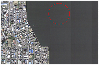
- The water surface surrounded by a circumference of a radius of 365.5 meters centered on a point of 35 degrees 21 minutes 37.4 seconds north latitude and 139 degrees 39 minutes 32.6 seconds east longitude
Area
- Water area:
- Approx. 420,000 square meters
Management
- U.S. Navy Yokosuka Base Headquarters in Japan
Conditions of use
- 1. The waters will be used for berthing and loading and unloading of U.S. vessels.
- 2. If the water area is not used by a U.S. vessel, the passage of general vessels is permitted. However, unless approved by the Government of the United States, underwater dredging, minesweeping, throwing, fishing, bottom seine netting and other similar tasks that damage buoys, berthing chains, etc. are strictly prohibited in this water area.
- 3. The Government of the United States shall take sufficient safety measures.
- (1) When installing buoys, etc., the mark shall be clearly marked with appropriate markings.
- (2) When using this water area, pay close attention to other vessels passing nearby.
- (3) U.S. vessels carrying hazardous materials shall place signs in the waters.
Inquiries to this page
Base Countermeasures Section, Urban Development Bureau Planning Department
Telephone: 045-671-2168
Telephone: 045-671-2168
Fax: 045-663-2318
Email address: tb-kichitaisaku@city.yokohama.lg.jp
Page ID: 973-437-454


