


- Yokohama-shi Top Page
- Municipal Government Information
- Policy and Initiatives
- Major Initiatives
- Base measures
- U.S. military facilities in the city
- Former Kamiseya Communication Facility
Here's the text.
Former Kamiseya Communication Facility
Last Updated March 22, 2024
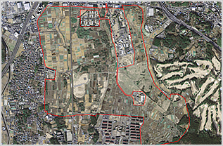
Aerial photograph of the former Kamiseya Communication Facility
Date of receipt
- March 15, 1951
Date of return
- June 30, 2015
Location:
- Seya Ward
- Kitamachi, Seyacho, Nakayashiki Sanchome
- Asahi Ward
- Kamikawai-cho
Area
- Land:
- 2,422,396 square meters
- State:
- 1,095,099 square meters (45.2%)
- City-owned:
- 226,801 square meters (9.4%)
- Private:
- 1,100,496 square meters (45.4%)
- Building:
- 23,327 square meters (National)
- Designation of regional districts, etc.:
- Urbanization adjustment area, Type 1 middle and high-rise residential area, semi-industrial area, semi-fire prevention area, Type 3 scenic area
(other than city planning) Agricultural promotion area, agricultural land area, agricultural exclusive area
Overview
- This facility has a fenced area surrounded by fences, and the outside of the fenced area was used by citizens as a baseball field, a plaza, etc., in addition to farmland that had been used for farming.
In addition, the so-called naval road passed north and south, and traffic was allowed before the return. - About approach of land use, please see this (land use of former Kamiseya communication facility).
Progress
- March 15, 1951
- The U.S. military requisitioned the former Japanese Navy warehouse facilities (August 1945), and was once canceled (October 16, 1947), and the Ministry of Agriculture and Forestry proceeded with the sale of land to local farmers as pioneering property. Was requisitioned.
- March 31, 1960
- The Japan-U.S. Joint Committee agreed to set up radio interference prevention areas on 945 hectares in the surrounding area.
- January 25, 1962
- The Japan-U.S. Joint Committee agreed on radio interference prevention areas and restrictions standards.
- February 27, 1969
- The Japan-U.S. Joint Committee agreed to jointly use some land for udo cultivation.
- March 22, 1973
- The Japan-US Joint Committee agreed on the joint use of some land for the burial of water pipes.
- November 21, 1973
- Regarding the use of the naval road in the facility, it was agreed as a provisional measure by the local commander until the joint use of the U.S.-Japan Joint Committee (US military, prefectural, prefectural police, city, Yokohama Defense Facilities Bureau).
- September 27, 1976
- It was designated as evacuation area.
- March 20, 1977
- The state-owned farmland in the facility was sold to 167 cultivators on the land (sale area of about 107 hectares). In November 1977, about 0.5 hectares were sold to four people, and in March 1984, about 1.9 hectares were sold to ten people.
- April 1, 1977
- The naval road site (40,599 square meters) in the facility was transferred to Motoichi.
- September 8, 1977
- The Japan-US Joint Committee agreed to jointly use some land of the communication facilities for maintenance and management of the river improvement work on the Aizawa River.
- April 1, 1978
- Agricultural land in the facility (181,501 square meters) was transferred to Motoichi.
- December 6, 1979
- At the Japan-US Joint Committee, the joint use of facilities for farmland maintenance (primary) was agreed.
- December 20, 1979
- The joint use of naval roads was agreed upon by the Japan-US Joint Committee.
- August 14, 1980
- Joint use for water pipe burial was agreed by the Japan-US Joint Committee.
- February 20, 1982
- The river improvement work on the Aizawa River has been completed.
- March 31, 1982
- The naval road widening maintenance work (inside the facility, two lanes) has been completed.
- September 24, 1982
- The Japan-U.S. Joint Committee agreed to jointly use some land of the telecommunications facilities for maintenance and management of the river improvement work on the O Kadogawa River.
- March 31, 1984
- The first farmland maintenance work has been completed. (Construction started on February 9, 1980)
- July 18, 1988
- With the completion of the O-Kadogawa River Rehabilitation Project, a maintenance site (6,273.26 square meters) was transferred to Motoichi.
- March 30, 1992
- A letter of understanding on agriculture was concluded between the four parties: the Kamiseya Agricultural District Council, the Kamikawai Agricultural District Council, the U.S. Navy in Japan and the Yokohama Defense Facilities Bureau.
- April 1, 1995
- The radio interference prevention area set around the facility has been abolished.
- October, 2003
- The headquarters located at the facility moved to Misawa Airfield, Aomori Prefecture.
- October 18, 2004
- The Japan-U.S. Joint Committee agreed on the return policy.
- August, 2008
- Housing and related facilities have been closed.
- April 10, 2009
- Concluded a memorandum of understanding with the U.S. Navy Atsugi Aviation Facility Headquarters on joint activities of disaster response preparation and disaster relief for Kamiseya communication facilities.
- January, 2011
- Security by stationing has been changed to security by some patrols.
- June, 2015
- The whole area has been returned.
- July 1, 2015
- The Seya Ward Kami-Seya Communication Facility Return Measures Council was established by the chairman of the Seya Ward 12 District Association for the purpose of discussing the use of the former site after the return of the Kami-Seya Communication Facility and the issues associated with the return, and communicating the opinions and requests of residents to related organizations.
- July 1, 2015
- With the approval of access to state-owned land from the government, the use of baseball stadiums and passages was started. In addition, cultivation on state-owned land was approved for use until the end of June 2017, and cultivation in the open field was approved until the end of June 2016.
- October 1, 2015
- The “Old Kamiseya Communication Facility Public Open Space Utilization Management and Management Liaison Committee” was set up and the use of baseball was started.
- March 28, 2016
- About 450 meters of Loop Route 4 (Kamiseya area) has been opened.
- April, 2016
- The “Agricultural Promotion Zone” and “Land Utilization Zone” have been announced.
- October, 2016
- Requested the government to cooperate in considering the holding of an international horticultural exposition at the former Kami Seya Communication Facility.
- March, 2017
- "How to proceed with the study of land use in the future" was announced.
- November, 2017
- The "Former Kami Seya Communication Facility Town Development Council" was established by private landowners.
Inquiries to this page
Base Countermeasures Section, Urban Development Bureau Planning Department
Telephone: 045-671-2168
Telephone: 045-671-2168
Fax: 045-663-2318
Email address: tb-kichitaisaku@city.yokohama.lg.jp
Page ID: 698-890-522


