


Here's the text.
C-089: Area around Futamatagawa Station
City planning decision: October 14, 2011 / City planning change: July 14, 2017
Last Updated December 9, 2022
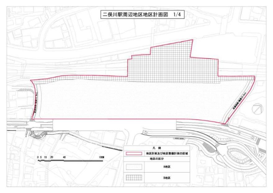
Plan (division of district)
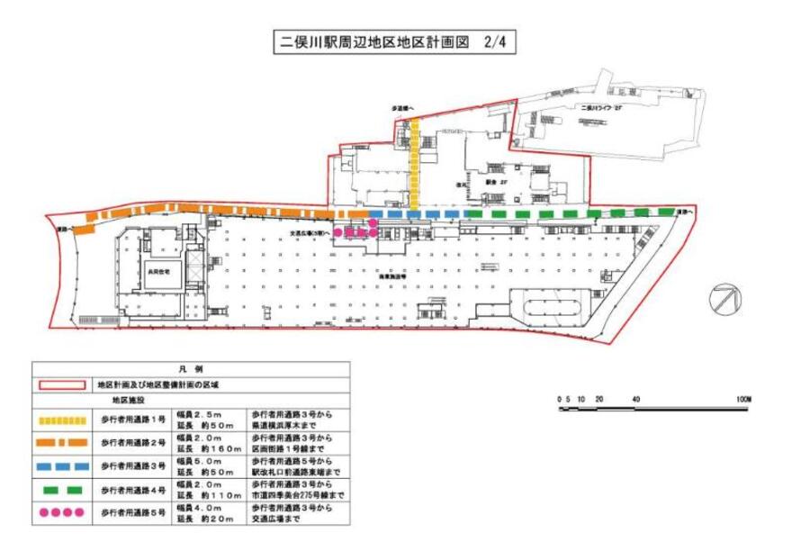
Plan (location of district facilities)
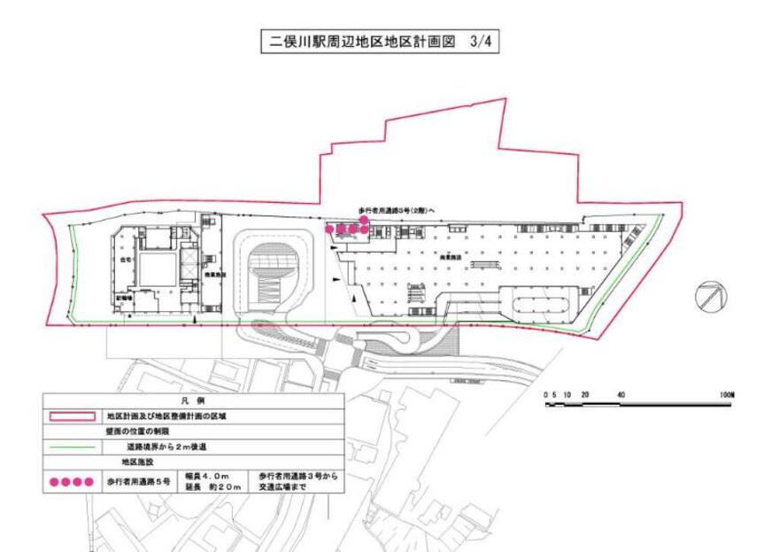
Plan (restriction of position of wall surface and placement of district facilities)
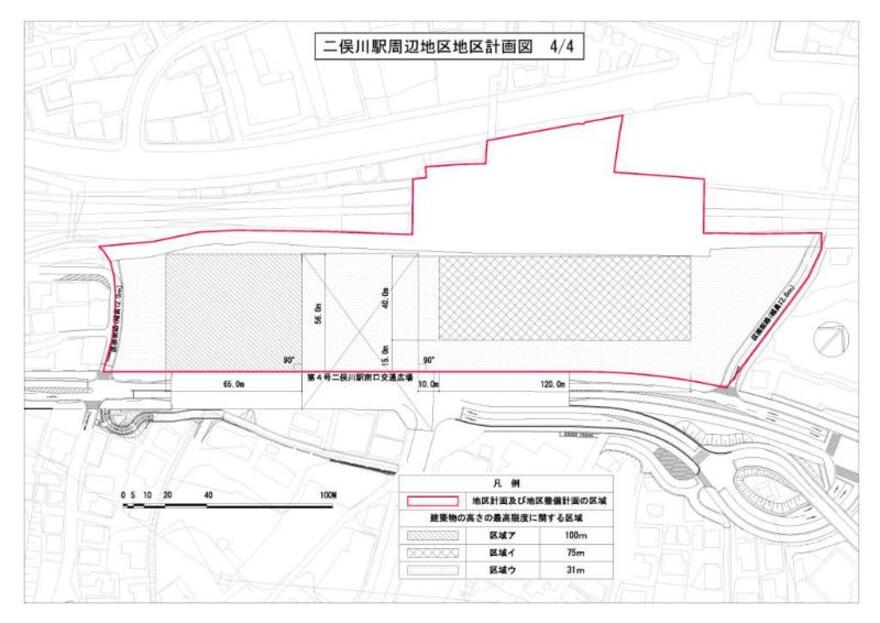
Plan (areas related to the maximum height of buildings)
| Name | Futamatagawa Station Area District Planning | |
|---|---|---|
| Position | 1-chome Futamatagawa, Asahi-ku, Yokohama, 2-chome, Futamatagawa | |
| Area | About 2.7ha | |
| Ward Areas No 1. Bill ・ Opening Departure Oh Bi Hoping All No Sir Needle |
Targets of District Planning | This area consists of the Futamatagawa Station, which is a traffic junction between the Sotetsu Main Line and Izumino Line, and the area around its south exit. Under the City Planning Master Plan, Asahi Ward Plan, the Kamoi Kamiiida Line (hereinafter referred to as the "Kamoi Kamiiida Line"), the adjacent urban planning road No. 3, 4, and 12. In addition, the plans for the Eastern Kanagawa Line (Sotetsu / JR Direct Line and Sotetsu / Tokyu Direct Line) require further potential and improvement of competitiveness. This district plan aims at rational and sound advanced use of land and renewal of urban functions by maintenance of public facilities, business, commercial facilities, urban housing, etc. through urban redevelopment projects, etc., and forms of buildings The purpose is to create a good complex urban area suitable for a regional base centered on a station, which is a traffic node, and maintain the environment by systematically guiding such as the like and securing pedestrian space. |
| Land Use Policy | In order to form a good complex urban area suitable as a regional base centered on the station, which is a traffic node, and to improve the convenience of Futamatagawa Station, the area is divided into two and the land use policy is determined as follows. . District A |
|
| Policy for the development of district facilities | In order to improve the convenience of Futamatagawa Station, a safe and comfortable pedestrian passage (indoor or outdoor) will be maintained in consideration of the station, the north exit and the south exit traffic plaza, and the east-west pedestrian network. | |
| Policy for maintenance of buildings, etc. | 1 In the A district, by systematically guiding the forms of buildings maintained by the urban redevelopment project, a good urban area environment suitable as a regional base centered on the station, which is a traffic node In order to maintain the environment, restrictions on the use of buildings, restrictions on the position of walls, the maximum height of buildings, restrictions on form designs such as buildings, and the minimum greening rate of buildings are determined. 2 In district B, we establish restrictions on use of building to plan location of city function taking advantage of convenience of station. |
|
| Greening Policy | We plan greening in district for maintenance, guidance of moist and attractive urban environment. | |
| C-089 District Development Plan | ||||
|---|---|---|---|---|
| Placement and scale of district facilities | Passage No. 1 for pedestrians |
Width 2.5m |
||
Passage No. 2 for pedestrians |
Width 2.0m |
|||
Passage No. 3 for pedestrians |
Width 5.0m |
|||
Passage No. 4 for pedestrians |
Width 2.0m |
|||
Passage No. 5 for pedestrians |
Width 4.0m |
|||
| Construction Construction Goods Etc. Ni Seki S L A matter Section |
Classification of district |
Name |
District A |
District B |
Area |
Approx. 1.9ha |
Approx. 0.8ha |
||
| Restrictions on the use of buildings | The following buildings must not be constructed. 1 Factories (excluding those attached to stores, restaurants and other buildings for similar purposes) 2 Majongya, Pachinkoya, shooting ground, Katsuma voting ticket sales office, off-site ticket sales office or off-site Katsufune voting ticket sales office 3 Cabarets, restaurants, nightclubs, dance halls and the like 4 Public baths pertaining to the bathhouse business with private rooms and other similar Building Standards Law Enforcement Ordinance (Government Ordinance No. 338 of 1950) Article 130-9-3 ※As defined in 5 Those to be used for storage or disposal of dangerous goods (excluding storage facilities for own use and other similar ones) |
|||
| Restrictions on the position of the wall | The outer wall of the building or the surface of the pillar in place of this shall not be built beyond the limit of the position of the wall shown in the plan drawing. But it is not this limit about building corresponding to any of the following or part of building. 1 Public toilets, police officers and other similar public interest 2 Public corridors 3 Elevators, escalators, stairs or slopes for moving up and down to public walkways |
___________ |
||
| Maximum height of buildings | The height of the building must not exceed 100m in Area A shown in the plan drawing, 75m in Area A, and 31m in Area C. | ___________ |
||
| Restrictions on form design of buildings, etc. | 1 The form design of the building shall conform to the following matters in order to reduce the feeling of oppression. (1) The color of the part of the building with a height of more than 31m shall be based on a monthly color system with a brightness of 5 or more and a saturation of 4 or less in the Munsell color system. (2) The part of the building exceeding the height of 31m in the area of i shown in the plan drawing shall be 70m or less in the horizontal direction projected on the lead surface of the part. 2 Building equipment installed on the roof should not have a messy appearance, such as surrounding with shields in harmony with the building. Restrictions on 3 outdoor advertising materials shall be as follows. (1) Outdoor advertising materials (excluding those that display their own name, store name or trademark, combinations of independent characters, marks, etc. in the contents of their own business or business or business, or those that display necessary items for management) are 31m in height Do not install in areas beyond. (2) Do not install outdoor advertising materials on the rooftop (including towers and excluding the rooftop floor where traffic plazas are installed). Form design such as 4 buildings shall be harmonized as the whole buildings in area of this city planning. |
___________ |
||
| Minimum of greening rate of buildings | 6.5/100 | ___________ |
||
※ Due to the revision of the Building Standards Law (enforced on April 1, 2018), Article 130-9-3 of the Building Standards Law Enforcement Order, which is described in "Restrictions on Use of Buildings, etc." Has been revised to Article 130-9-5.
Since restrictions on forms or designs such as buildings in this district are stipulated in the City Planning Ordinance, procedures for certification of form designs are required in addition to notification.
Because "minimum greening rate of building" of this district is stipulated in the city planning regulations, procedures such as certificates about conformity of tree planting rate may be necessary before report.
The area around Futamatagawa Station is also designated as a city planning consultation area.
Inquiries to this page
Urban Development Bureau Regional Town Development Department Regional Town Development Division
Telephone: 045-671-2667
Telephone: 045-671-2667
Fax: 045-663-8641
Email address: tb-chiikimachika@city.yokohama.lg.jp
Page ID: 370-052-670


