


現在位置
- Yokohama-shi Top Page
- Living and Procedures
- Community Development and Environment
- Urban Development
- District planning, building agreements, etc.
- District planning
- District planning for each ward
- Asahi Ward
- C-048: Tsurugamine Station South Exit Area
Last Updated December 9, 2022
Here's the text.
C-048: Tsurugamine Station South Exit Area
City planning decision: February 15, 2002 / City planning change: July 14, 2017
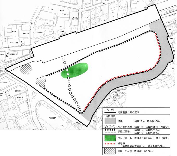 Plan drawings (district facilities)
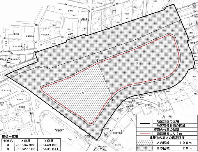 Plan drawing (restriction of wall position, maximum height of building)
| Name | Tsurugamine Station South Exit District Planning | |
|---|---|---|
| Position | 1-chome, Tsurugamine 1-chome and Tsurugamine 2-chome, Asahi-ku, Yokohama | |
| Area | Approx. 1.8ha | |
| Ward Areas No 1. Bill ・ Opening Departure Oh Bi Hoping All No Sir Needle |
Targets of District Planning | This area is located in front of Tsurugamine Station on the Sagami Railway Line, and the area around Futamatagawa and Tsurugamine Station, including this area, is positioned as a subcenter in the "Yumehama 2010 Plan". It promotes the renewal of urban functions, and aims to create a new subcenter centered on strengthening terminal functions as the center of civil life. In this district plan, we plan to develop it as a terminal base for a new transportation network around Tsurugamine Station, improve the traffic environment at the station and station square, such as road maintenance in the district, and at the same time, as a leading development in the formation of a subcenter The goal is to promote urban redevelopment projects and effective use of land, and to strengthen various functions such as commerce and urban housing. |
| Land Use Policy | Utilizing the location characteristics in front of the station, urban redevelopment projects will promote non-combustible buildings and rational and sound advanced use of land. In addition, we perform public facilities such as roads and plan reinforcement improvement of station and station square traffic function and maintenance of commercial, service function appropriate for station square of Fukutoshin and good urban house. | |
| Policy for the development of district facilities |
|
|
| Policy for maintenance of buildings, etc. | Inducing the location of facilities (commercial, urban-type houses, etc.) appropriate for the station square in the subcenter, promoting advanced use, creating pedestrian spaces by retreating walls, etc., and maintaining green belts in consideration of the surrounding environment In order to promote the improvement of disaster prevention and the improvement of the urban environment, restrictions on the use of buildings, restrictions on the position of walls, the maximum height of buildings, and restrictions on the form or design are determined. | |
| c-048 District Development Plan | ||||||||
|---|---|---|---|---|---|---|---|---|
| Placement and scale of district facilities | Roads |
Width 12m, length 190m | ||||||
Aisles for pedestrians |
Width 4m length 80m | |||||||
Sidewalk-like open space |
Width: 2m extension: 210m Width 1m length 170m |
|||||||
Playlot |
Approximately 240㎡ | |||||||
Green zone |
Width 1m extension about 60m | |||||||
Open space |
Approximately 320㎡ | |||||||
| Construction Construction Goods Etc. Ni Seki S L A matter Section |
Restrictions on the use of buildings | The following buildings must not be constructed.
|
||||||
| Restrictions on the position of the wall | The outer wall of the building or the surface of the pillar in place of this shall not be built beyond the limit of the position of the wall shown in the plan drawing. But it is not this limit about building corresponding to any of the following or part of building.
|
|||||||
| Maximum height of buildings | The height of the building in the area shown in the left column of the table below must not exceed the numerical value shown in the right column of the table below.
|
|||||||
| Restrictions on the form or design of buildings | Regarding the form, design, color, etc. of the building, consideration shall be given to harmony with the surrounding area, and no stimulating colors or decorations shall be used. | |||||||
※ Due to the revision of the Building Standards Law (enforced on April 1, 2018), etc., Article 130-9-3 of the Building Standards Law Enforcement Order, which is described in "Restrictions on Use of Buildings, etc." Has been revised to Article 130-9-5.
Inquiries to this page
Urban Development Bureau Regional Town Development Department Regional Town Development Division
Telephone: 045-671-2667
Telephone: 045-671-2667
Fax: 045-663-8641
Email address: tb-chiikimachika@city.yokohama.jp
Page ID: 650-664-542


