Here's the text.
C-047: Hodogaya Buddha Mukomachi district
City planning decision: January 15, 2002 / City planning change: August 13, 2010
Last Updated December 9, 2022
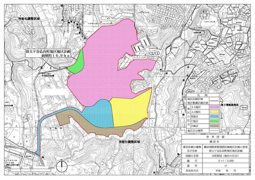
 Plan drawing (division of district)
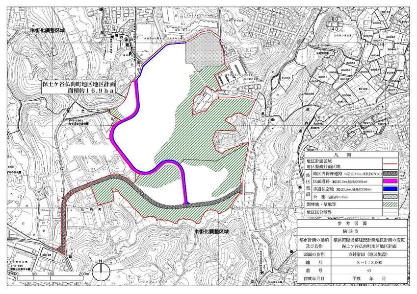
 Plan drawings (district facilities, forest land, grassland, etc.)
| Name | Hodogaya Buddha Mukomachi District Planning | |
|---|---|---|
| Position | Fukumukai-cho, Hodogaya-ku, Yokohama-shi and Ichizawa-cho, Asahi-ku | |
| Area | Approx. 16.9ha | |
| Ward Areas No 1. Bill ・ Opening Departure Oh Bi Hoping All No Sir Needle |
Targets of District Planning | Almost all areas of this area are located in the urbanization adjustment area adjacent to the urbanization area, and have rich green spaces. Under the “Master Plan for Urban Planning and Hodogaya Ward Plan,” the development of green spaces in conservation, parks that make use of nature and the location of welfare facilities are positioned. In addition, the “Yokohama City Water and Green Basic Plan” is included in “Kawashima / Buddha Hill”, one of the seven hills that look into the city area, and the basic policy of the plan states that “Buddha Hill is We will focus on securing and utilizing it as a green base in the center of the city. " In this area, development projects are being conducted for the purpose of constructing welfare facilities for the elderly, etc. in response to an aging society, and it is required that this development project be in harmony with the surrounding good natural environment. I have. For this reason, the District Plan aims to maintain and improve the effects of infrastructure development through development projects, to establish welfare facilities for the elderly in harmony with the surrounding environment, and to create a favorable natural environment in conservation centered on green spaces in the development area. |
| Land Use Policy | Divide five districts and guide land use according to the following policies.
|
|
| Policy for the development of district facilities | A 10.5m wide road that runs east and west on the south side of the district, a 6.5m wide road that runs north and south through the development area, and a 2.5m wide sidewalk-like open space that takes into account the natural environment. In addition, a park will be built on the north side. |
|
| Policy for maintenance of buildings, etc. | Depending on the characteristics of each district, it is determined as follows.
|
|
| Greening Policy | We perform greening in site and greening in public space, and ratio of green space area including area of park to total area of A-1, A-2, B, C district is approximately 50%. | |
| Policy on conservation for forest land, grassland, etc. | In order to create conservation, a green space that forms a favorable natural environment, we shall define matters related to conservation such as forest land and grassland. | |
| C-047 District Development Plan | |||||||
|---|---|---|---|---|---|---|---|
| Placement and scale of district facilities | Main roads in the district |
Width: 10.5m, length: 760m | |||||
Divided roads |
Width: 6.5m, length: 600m | ||||||
Sidewalk-like open space |
Width: 2.5m, length: 790m | ||||||
Park |
Area approximately 1.0ha | ||||||
| Construction Construction Goods Etc. Ni Seki S L A matter Section |
Classification of district | Name |
A-1 District |
A-2 District |
District B |
District C |
District D |
Area |
Approx. 10.3ha |
About 2.4ha |
About 2.1ha |
Approx. 0.4ha |
Approx. 1.7ha |
||
| Restrictions on the use of buildings | The following buildings must not be constructed.
|
Buildings other than those listed below must not be built.
|
The following buildings must not be constructed.
|
- |
|||
| Maximum floor area ratio of buildings | 7/10 |
5/10 |
8/10 |
||||
| Maximum building coverage ratio | 4/10 |
||||||
| Minimum site area of buildings | 30,000㎡ |
20,000㎡ |
10,000㎡ |
1,000㎡ |
|||
Provided, however, that this shall not apply to land that falls under any of the following.
|
|||||||
| Restrictions on the position of the wall | The distance from the outer wall of the building or the surface of the pillar in place of this to the boundary of the front road and the boundary of the adjacent land shall be 5m or more. | The distance from the outer wall of the building or the surface of the pillar in place of this to the boundary of the front road and the boundary of the adjacent land shall be 3m or more. | |||||
| Maximum height of buildings |
|
|
|||||
| Restrictions on form design of buildings, etc. | About outdoor advertising matter, we decide not to install on the roof and roof of building and shall be in harmony with neighboring scenery when we install in other places. | ||||||
| Restrictions on the structure of a fence or fence | The structure of the fence or fence facing the main road or division road in the district shall have hedges, fences and other openness. However, this excludes fence foundations, gateposts, gates and the like. | ||||||
| SAT Land No Interest For use Ni Seki S L A matter Section |
Matters related to conservation, such as forest land, grassland, etc. | In areas such as forest land, grassland, etc. indicated in the plan drawing, among the following acts, acts that interfere with the conservation of the green space shall not be performed.
|
|||||
Inquiries to this page
Urban Development Bureau Regional Town Development Department Regional Town Development Division
Telephone: 045-671-2667
Telephone: 045-671-2667
Fax: 045-663-8641
Email address: tb-chiikimachika@city.yokohama.jp
Page ID: 434-488-756


