


Here's the text.
C-009:
City planning decision: August 5, 1988 / City planning change: March 3, 2006
Last Updated December 9, 2022
Plan drawing
| Name | Seya Inventory Honmachi District Planning | |
|---|---|---|
| Position | Inventory Honmachi and Kitamachi, Seya-ku, Yokohama, and Kamikawai-cho, Asahi-ku | |
| Area | Approx. 16.6ha | |
| Development and Development of Areas and conservation's Policy | Targets of District Planning | The Seya Inventory Honmachi area is an accumulation area of wholesale distribution business facilities that are blessed with traffic conditions, such as being located about 1 km from the Yokohama Machida Interchange of the Tomei Expressway. Since the completion of housing complex in 1974, housing complex has played a central role as a core wholesale distribution district of the city. With the development of housing complex and changes in social conditions, it has become necessary to expand and renew facilities and ensure the integrity of land use. The Plan aims to create a wholesale distribution base by promoting rational advanced use of land, preserving the housing complex environment and maintaining and strengthening the wholesale distribution function of the Area. |
| Land Use Policy | Prevent the mixture of applications that hinder wholesale distribution functions, maintain harmonious land use in each block, and establish locations such as nuclear facilities, service facilities, and shared parking lots that contribute to enhancing the functions of the wholesale housing complex. In addition, we perform greening of district as much as possible and consider scenery and maintain improvement of district environment. |
|
| Policy for the development of district facilities | In order to respond to parking demand in the district, public vacant lots (parking lots) will be properly arranged. In addition, about park, we plan maintenance as place of relaxation of worker. |
|
| Policy for maintenance of buildings, etc. | Set the necessary standards for building use, height, minimum floor area, restrictions on wall position, etc., in order to purify use, effectively use the site, secure public space, and guide the conservation of a good landscape. In addition, when arranging buildings, more than one-tenth of the site area will be effectively secured as cargo handling or parking space on the site. |
|
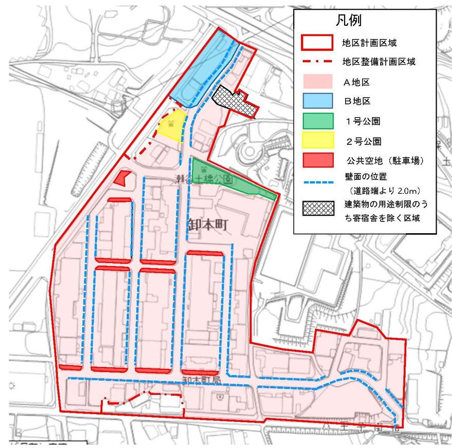
| c-009 District Development Plan | |||||
|---|---|---|---|---|---|
| Placement and scale of district facilities | Name | Scale | Remarks | ||
| No. 1 Park | Approx. 0.3ha | As shown in the plan drawing | |||
| No. 2 Park | Approx. 0.1ha | As shown in the plan drawing | |||
| Public vacant lots (parking lots) | Approx. 0.3ha | A total of 11 locations as shown in the plan diagram. | |||
| Construction Construction Goods Etc. Ni Seki S L A matter Section |
Subdivision of the district | District A (approximately 15.6ha) | District B (approximately 0.5ha) | ||
| Restrictions on Use of Buildings, etc. | Buildings listed in the following items shall not be constructed. However, the area shown in the plan drawing excludes the dormitory. | ||||
| 1 House, apartment house, dormitory or boarding house (the ratio of the total area of the part provided for these uses to the site area is within 5/10, and is located on the third floor or higher and offices, stores and other similar items Excluding those attached to.) 2 Hotels or Ryokans 3 Public baths 4 Bowling alleys, skating rinks, swimming pools and similar sports facilities 5 Majangya, Pachinkoya, shooting range, Katsuma voting ticket sales office, off-site ticket sales office, and the like |
1 The basement or 1st floor is used for housing, apartment houses, dormitories or boarding houses 2 Hotels or Ryokans 3 Public baths 4 Bowling alleys, skating rinks, swimming pools and similar sports facilities 5 Majangya, Pachinkoya, shooting range, Katsuma voting ticket sales office, off-site ticket sales office, and the like |
||||
| Maximum ratio of total building area to site area | ―― | The part to be used for the house of the building, including the part to be used for the house or the part to be used for the house (including facilities such as stairs, elevators, corridors, etc.) attached to the part) The maximum ratio of the total area to the site area shall be 20/10. | |||
| Maximum height of buildings | 1 The height of the building must not exceed 25m. 2 The height of each part of the building is 10m added to the one obtained by multiplying the horizontal distance in the true north direction from each part to the boundary of the city planning area or the boundary of the park specified in the district facility by 0.6. Must be less than or equal. |
―― | |||
| Minimum site area of buildings | The site area of the building shall be 300 m2 or more. Provided, however, that this shall not apply to land where ownership or other rights are currently owned and less than 300 m2 is used as one site on the notification date. | ||||
| Restrictions on the position of the wall | The outer wall of the building or the pillars or gates or gaps in place of this shall not be built beyond the wall line displayed in the plan drawing. But it is not this limit that the mayor recognized that it is unavoidable for public interest or safety management. | ||||
| Restrictions on forms or designs of buildings, etc. | The colors of the roof and outer walls of the building and the colors, sizes and shapes of outdoor advertising materials shall be in harmony with the landscape of the district. | ||||
| Restrictions on the structure of a fence or fence | Hedges and other similar openness. | ||||
Inquiries to this page
Urban Development Bureau Regional Town Development Department Regional Town Development Division
Telephone: 045-671-2667
Telephone: 045-671-2667
Fax: 045-663-8641
Email address: tb-chiikimachika@city.yokohama.lg.jp
Page ID: 973-654-863


