


- Yokohama-shi Top Page
- Living and Procedures
- Community Development and Environment
- Urban Development
- District planning, building agreements, etc.
- District planning
- District planning for each ward
- Tsuzuki Ward
- C-073: Kamiyabune district, Tsuzukiikebe-cho
Here's the text.
C-073: Kamiyabune district, Tsuzukiikebe-cho
City planning decision: October 25, 2005
Last Updated December 9, 2022
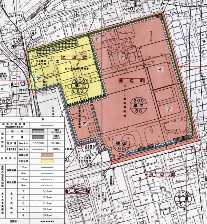
Plan drawing (district facilities, division of district, restriction of wall position, maximum height)
| Name | Kamiyabune District, Tsuzuki Ikebe-cho District Plan | |
|---|---|---|
| Position | Ikebe-cho, Tsuzuki-ku, Yokohama | |
| Area | Approx. 14.1 ha | |
| Ward Areas No 1. Bill ・ Opening Departure Oh Bi Hoping All No Sir Needle |
Targets of District Planning | The area is located about 700m north of Kamoi Station on the JR Yokohama Line and along the Kawasaki Machida Line on the city planning road, with high traffic convenience. In the surrounding area, factories of various sizes are located because of the industrial area, but on the other hand, land use conversion to residential areas has progressed and idle land has been seen, and commercial accumulation is slightly on the south side of Kamoi Station. It is just to be seen. For this reason, by promoting the advanced use of land while harmonizing with the surrounding industrial and living environment, urban housing, commercial service facilities, cultural and public interest facilities, etc. will be introduced to contribute to regional revitalization and exchange. The goal is to do. |
| Land Use Policy | Divide two districts and guide land use appropriate for each district while harmonizing with surrounding factories and residential areas.
|
|
| Policy for the development of district facilities | We maintain promenade, open space to secure comfortable and spacious pedestrian space. In addition, by securing a cohesive green space in the district, harmony with surrounding factories and residential areas will be achieved. |
|
| Policy for maintenance of buildings, etc. | In order to preserve a good living and commercial environment while harmonizing with the surrounding industrial and living environment, restrictions on the use of buildings, minimum site area of buildings, maximum height of buildings, etc. Establish necessary restrictions. | |
| Greening Policy | In order to reduce the burden on the environment and create a harmonious green urban space, we will actively promote greening on the premises in consideration of the connection with the plaza. | |
| District maintenance plan | |||||
|---|---|---|---|---|---|
| Placement and scale of district facilities | Green space | 1 area Approx. 2,000㎡ | |||
| Open space | 3 Areas Approx. 850㎡ | ||||
| Promenade | Width 4m length 1,345m | ||||
| Sidewalk-like open space | Width 2m extension about 320m | ||||
| Construction Construction Goods Etc. Ni Seki S L A matter Section |
Classification of district | Name | Commercial district | Residential areas | |
| Area | Approx. 10.9 ha | About 3.2 ha | |||
| Restrictions on Use of Buildings, etc. | Buildings listed in the following items shall not be constructed.
|
Buildings listed in the following items shall not be constructed.
|
|||
| Minimum site area of buildings | 1,000㎡ Provided, however, that this shall not apply to public toilets, police officers, and other similar buildings that are used as sites for public interest. |
||||
| Restrictions on the position of the wall | The outer wall of the building or the surface of the pillar in place of this shall not be built beyond the position of the wall shown in the plan drawing. But it is not this limit when building or part of building in distance less than limit of this distance corresponds to any of next kakugo.
|
||||
| Maximum height of buildings |
|
|
|||
Inquiries to this page
Urban Development Bureau Regional Town Development Department Regional Town Development Division
Telephone: 045-671-2667
Telephone: 045-671-2667
Fax: 045-663-8641
Email address: tb-chiikimachika@city.yokohama.lg.jp
Page ID: 799-542-651


