- Yokohama-shi Top Page
- Living and Procedures
- Community Development and Environment
- Urban Development
- District planning, building agreements, etc.
- District planning
- District planning for each ward
- Midori Ward
- C-079: North Exit District of Nagatsuta Station
Here's the text.
C-079: North Exit District of Nagatsuta Station
City planning decision: December 25, 2007 / City planning change: July 14, 2017
Last Updated December 12, 2022
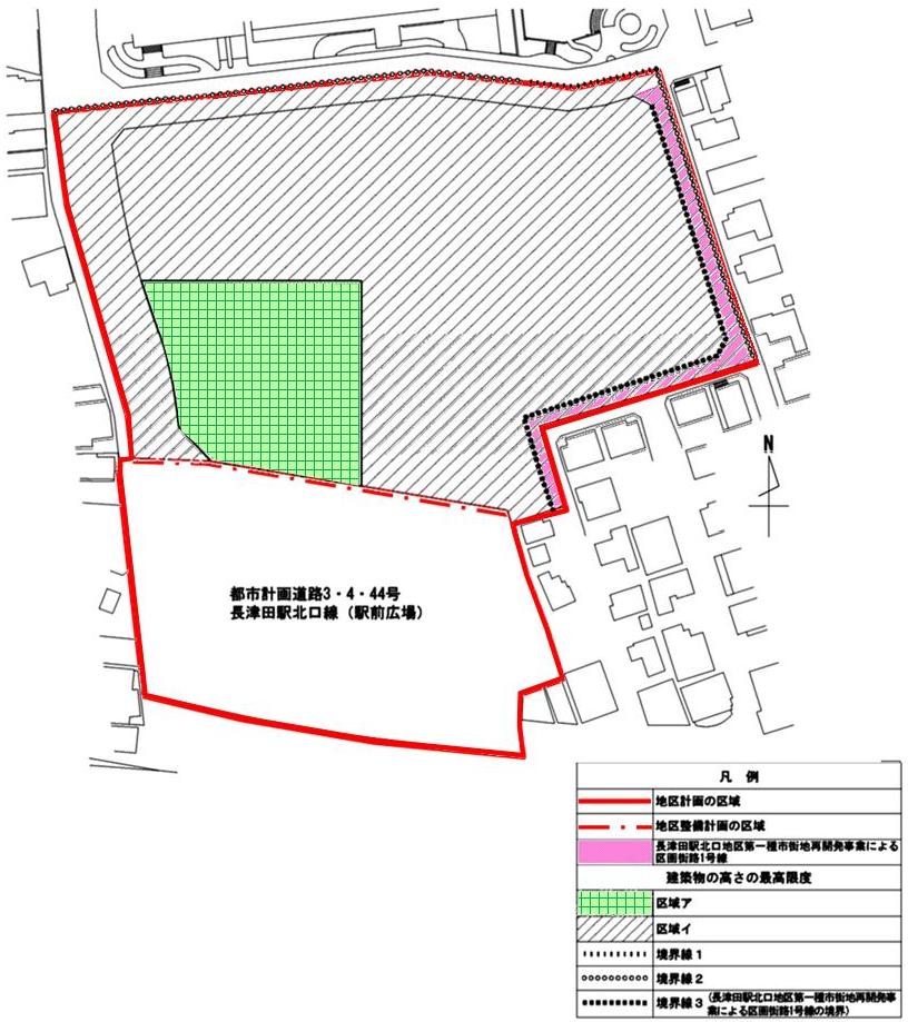
 Plan drawing (maximum height of building)
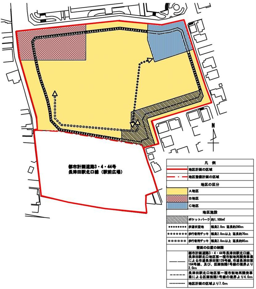
 Plan drawing (restrictions on district division, district facilities, and wall position)
| Name | Nagatsuta Station North Exit District Planning | |
|---|---|---|
| Position | 2-chome Tsuda and 4-chome Nagatsuda, Midori Ward, Yokohama City | |
| Area | Approx. 2. 2ha | |
| Ward Areas No 1. Bill ・ Opening Departure Oh Bi Hoping All No Sir Needle |
Targets of District Planning | This area is located in front of the north exit station of Nagatsuta Station, which is the traffic junction of the Tokyu Denentoshi Line, Yokohama Minatomirai Railway Children's Country Line and JR Yokohama Line, and is adjacent to shopping streets and residential areas. Most of the area is low and unused land, such as the former site of Municipal Housing, and maintenance of public facilities such as station squares and roads is delayed. Under the Midori Ward Town Development Plan of the City Planning Master Plan and the Midori Ward Plan, the district is positioned to promote urban redevelopment projects at the north exit as a policy for town development around Nagatsuta Station. It is also positioned as a district in the Yokohama Medium-Term Plan to promote development around the base stations. This district plan aims to improve the rational and sound advanced use of land and renew urban functions by improving public facilities, commercial facilities, public facilities, and urban housing through urban redevelopment projects. Bases in the surrounding area (hereinafter referred to as "local bases") The goal is to create and maintain a good complex urban area that is appropriate for the surrounding residential areas. |
| Land Use Policy | In order to strengthen the function as a traffic node at Nagatsuta Station, the city planning road No. 3.4.44 Nagatsuta Station North Exit Line (station square) and the city planning parking lot No. 19 Nagatsuta Station North Exit Bicycle Parking Lot Maintenance. In addition, in consideration of contact to Nagatsuta Station, we will form a network of pedestrian spaces that travel around the entire area. At the same time, we aim to create an urban environment that is suitable for a regional base and takes into account the surrounding residential areas. Based on the above, the area excluding the station square is divided into three areas in this area, and the land use policy is determined as follows. District A
|
|
| Policy for the development of district facilities | In order to systematically create a safe, comfortable and attractive urban space, and to consider the surrounding residential areas, the policy for the development of district facilities is determined as follows.
|
|
| Policy for maintenance of buildings, etc. | We divide this district in the same way as policy of land use and establish policy of maintenance such as buildings as follows. District A
|
|
| Greening Policy | Greening is carried out in order to create a moist and attractive urban environment. In addition, we will strive for greening in consideration of surrounding residential areas. | |
| District maintenance plan | |||
|---|---|---|---|
| Land Ward Applied Set up No Distribution HOME Oh Bi Rule Imitation |
Pocket park (blue sky, non-blue sky) |
Approximately 1,100㎡ | Remarks We can establish about building corresponding to any of the following or part of building.
|
| Sidewalk-like open space (blue sky, non-blue sky) |
Width 2.0m Approximately 280m in length |
||
| Pedestrian deck (blue sky, non-blue sky) |
Width 2.0m or more Approximately 70m in length |
- | |
| Width 2.0m or more Approximately 95m in length |
|||
| Construction Construction Goods Etc. Ni Seki S L A matter Section |
Land Ward No Ward Minutes |
Name | District A | District B | District C |
|---|---|---|---|---|---|
| Area | About 1.2ha | Approx. 0.2ha | Approx. 0.1ha | ||
| The building Restrictions on Use |
The following buildings must not be constructed.
|
Buildings other than those listed below must not be built.
|
Buildings other than those listed below must not be built.
|
||
| Restrictions on the position of the wall | The outer wall of the building or the surface of the pillar in place of this shall not be built beyond the limit of the position of the wall shown in the plan drawing. But it is not this limit about building corresponding to any of the following or part of building.
|
||||
| The building Maximum height limit |
|
||||
| Restrictions on form design of buildings, etc. |
|
||||
| A fence or a fence Restrictions on the structure of the fence |
Fences or fences are hedges, fences, and similar openness, and do not impair the aesthetics. | ||||
※ Due to the revision of the Building Standards Law (enforced on April 1, 2018), Article 130-9-3 of the Building Standards Law Enforcement Order, which is described in "Restrictions on Use of Buildings, etc." Has been revised to Article 130-9-5.
Inquiries to this page
Urban Development Bureau Regional Town Development Department Regional Town Development Division
Telephone: 045-671-2667
Telephone: 045-671-2667
Fax: 045-663-8641
Email address: tb-chiikimachika@city.yokohama.jp
Page ID: 564-198-186


