Here's the text.
C-046: Midori Miho District
City planning decision: December 25, 2001
Last Updated December 12, 2022
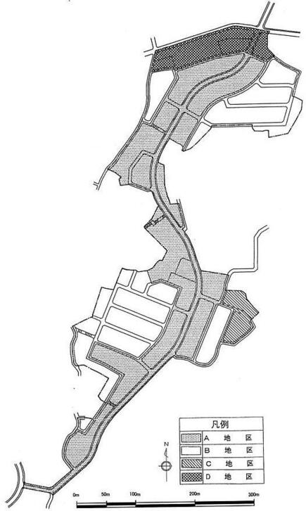
 Plan drawing (division of district)
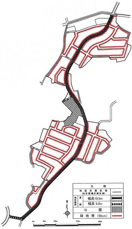
 Plan drawing (location of district facilities, green zone)
| Name | Midori Miho District District Planning | |
|---|---|---|
| Position | Mihocho, Midori-ku, Yokohama-shi | |
| Area | About 10.1ha | |
| Ward Areas No 1. Bill ・ Opening Departure Oh Bi Hoping All No Sir Needle |
Targets of District Planning | The Area is located in the central part of Midori Ward, approximately 1.5 km west of Nakayama Station on the JR Yokohama Line, and is located on a hill between the city planning road Yamashita Nagatsuta Line, Tokaichiba Route 386 and Kitahasaku No. 477. Most of the districts are designated as scenic areas, but they include collective farmland and forests, and if left untouched, it is expected that sprawl through individual development will be invited. It is a district where infrastructure is being maintained. This district plan is a suburban residential area with greenery and moisture in harmony with the natural environment for areas where urban infrastructure facilities such as roads that will be the framework of the district and parks that will be a place for relaxation for local residents through land readjustment projects. The goal is to create a good urban environment suitable for residential areas and to maintain scenic beauty. |
| Land Use Policy | In order to realize the goals of the city planning, we divide the districts into four and plan locations such as low-rise houses mainly in detached houses in each district. In addition, in order to create an attractive environment along roads in the district, we will maintain "green belts" and strive for conservation. | |
| Policy for the development of district facilities | In order to enhance the safety and convenience of the area, the city road Tokaichiba No. 386 and Kitahatsusaku No. 477 will be connected, and the main road in the area that runs north and south through this area will be developed through land readjustment projects. In addition, in order to make it a place for local residents to relax, a block park utilizing natural forests will be developed in the center of the district through a land readjustment project. |
|
| Policy for maintenance of buildings, etc. | In A district, B district, C district and D district, in order to form a good environment mainly composed of detached houses, restrictions on the use of buildings, minimum site area of buildings, restrictions on the position of walls And the maximum height of buildings, etc. | |
| Greening Policy | While forming a green cityscape with excellent scenic beauty, we promote active greening of the site of buildings, public facilities, etc., and green networks in which green spaces outside the adjacent area are linked to green spaces in the area Plan. | |
| District maintenance plan | ||||||
|---|---|---|---|---|---|---|
| Placement and scale of district facilities | Roads | Width 10.5m extension about 950m Width 8.0m extension about 50m |
||||
| Park | Approx. 3,500㎡ | |||||
| Construction Construction Goods Etc. Ni Seki S L A matter Section |
Classification of district | Name | District A | District B | District C | District D |
| Area | About 4.6ha | Approx. 4.4ha | Approx. 0.3ha | Approx. 0.8ha | ||
| Restrictions on the use of buildings | Buildings other than those listed below must not be built.
|
Buildings other than those to be raised next must not be built.
|
||||
| Maximum building coverage ratio | 4/10 | ______ | 4/10 | |||
| Minimum site area of buildings | 150㎡ | 130㎡ | ||||
Provided, however, that this shall not apply to land that falls under any of the following.
|
||||||
| Restrictions on the position of the wall | The distance from the outer wall of the building or the surface of the pillar in place of this to the boundary of the front road shall be 2m or more, and the distance to the adjacent land boundary shall be 1m or more. Provided, however, that this shall not apply if the building or the part of the building at a distance less than the limit of this distance falls under any of the following.
|
The distance from the outer wall of the building or the surface of the pillar in place of this to the boundary of the front road and the boundary of the adjacent land shall be 1 m or more. Provided, however, that this shall not apply if the building or the part of the building at a distance less than the limit of this distance falls under any of the following.
|
The distance from the outer wall of the building or the surface of the pillar in place of this to the boundary of the front road shall be 2m or more, and the distance to the adjacent land boundary shall be 1m or more. Provided, however, that this shall not apply if the building or the part of the building at a distance less than the limit of this distance falls under any of the following.
|
|||
| Maximum height of buildings |
|
______ | ||||
| Restrictions on forms or designs of buildings, etc. |
|
|||||
| Restrictions on the structure of a fence or fence | The structure of the fence or fence facing the road shall have hedges, fences and similar openness. However, this excludes fence foundations, gateposts, gates and the like. | |||||
| Restrictions on Land Use | Planting of green belts (width 50cm) displayed on the plan drawing must be maintained and preserved. However, this does not apply to entrances and exits such as parking lots. | |||||
Inquiries to this page
Urban Development Bureau Regional Town Development Department Regional Town Development Division
Telephone: 045-671-2667
Telephone: 045-671-2667
Fax: 045-663-8641
Email address: tb-chiikimachika@city.yokohama.lg.jp
Page ID: 519-985-905


