


- Yokohama-shi Top Page
- Living and Procedures
- Community Development and Environment
- Urban Development
- District planning, building agreements, etc.
- District planning
- District planning for each ward
- Kanazawa Ward
- C-088: Kanazawa Hakkei Station East Exit area
Here's the text.
C-088: Kanazawa Hakkei Station East Exit area
City planning decision: September 3, 2010 / City planning change: July 14, 2017
Last Updated December 9, 2022
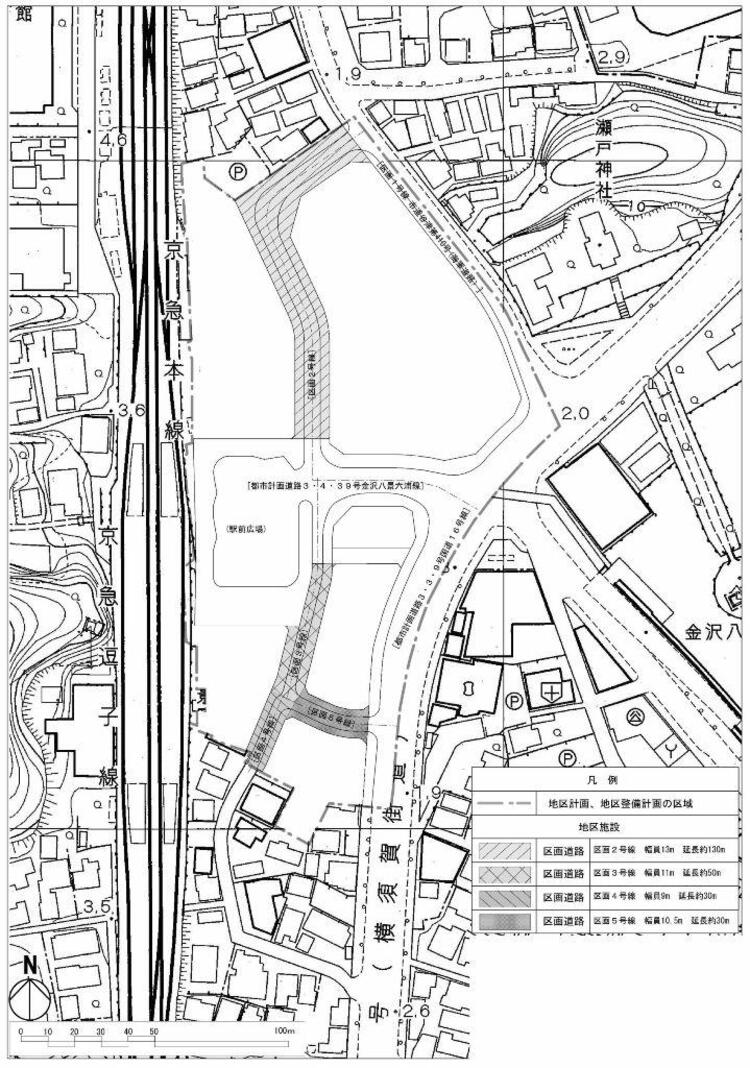 Plan drawing (location of district facilities)
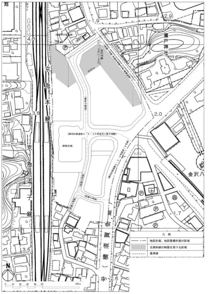 Plan drawing (restriction of wall position, reference line)
| Name | Kanazawa Hakkei Station East Exit District Planning | |
|---|---|---|
| Position | Seto, Kanazawa-ku, Yokohama-shi | |
| Area | About 2.4ha | |
| Ward Areas No 1. Bill ・ Opening Departure Oh Bi Hoping All Related to Sir Needle |
Targets of District Planning | This area is positioned as a base for promoting the location of commerce and service functions, etc. for the everyday life of citizens as a major railway station in the "Yokohama City Urban Planning Master Plan All City Plan". |
| Land Use Policy | In order to plan land use appropriate for the station square base where public transportation is connected, we will guide various land use such as commerce and service functions. In addition, we will create an urban space where many people gather through the advanced use of land, secure living functions that make use of the location characteristics in front of the station, and promote the non-combustible of buildings in order to improve disaster prevention. | |
| Development policy for district facilities | The land readjustment project will improve the convenience of traffic in front of the station, such as maintaining station squares and division roads, creating a safe and comfortable pedestrian space and ensuring smooth vehicle traffic. | |
| Policy for maintenance of buildings, etc. | In order to create liveliness as a station square base and create a landscape suitable for the base, we will set restrictions on the use of buildings and restrictions on form designs such as buildings. |
|
| c-088 District Development Plan | |||||
|---|---|---|---|---|---|
| Placement and scale of district facilities | Type | Name | Width | Extension | |
| Divided roads | Section 2 |
13m | Approx. 130m | ||
Section 3 |
11m | Approx. 50m | |||
Block No. 4 |
9m | About 30m | |||
Block No. 5 |
10.5m | About 30m | |||
| Construction Construction Goods Etc. Ni Seki S L A matter Section |
Restrictions on the use of buildings | The following buildings must not be constructed. 1 Those that provide the first floor for housing and do not fall under any of the following items. |
|||
| Maximum height of buildings | The height of each part of the building in the area subject to the restriction of the northern diagonal line shown in the plan drawing is 7.5 m added to the horizontal distance in the true north direction from that part to the reference line multiplied by 0.6. Must be less. | ||||
| Restrictions on form design of buildings, etc. | 1 The roof and outer wall of the building shall be considered in consideration of the surrounding landscape, such as refraining from stimulating colors or decorations. |
||||
Due to the revision of the Building Standards Law (enforced on April 1, 2018), Article 130-9-3 of the Building Standards Law Enforcement Order, which is described in "Restrictions on Use of Buildings, etc." Has been revised to Article 130-9-5.
Within the East Exit district planning area of Kanazawa Hakkei Station, the “Kanazawa Hakkei Station East Exit District Town Development Guidelines” are also set by local organizations.
Specifically, please refer to Urban Development Bureau area town development section.
Inquiries to this page
Urban Development Bureau Regional Town Development Department Regional Town Development Division
Telephone: 045-671-2667
Telephone: 045-671-2667
Fax: 045-663-8641
Email address: tb-chiikimachika@city.yokohama.jp
Page ID: 710-363-892


