


Here's the text.
C-033: Kanazawa Higashi-Asahina district
City planning decision: November 26, 1996
Last Updated December 9, 2022
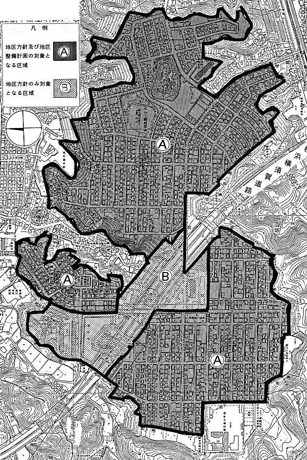
Plan drawing (division of district)
| Name | Kanazawa Higashi-Asahina District Planning | |||
|---|---|---|---|---|
| Position | Asahina-cho, Kanazawa-ku, Yokohama-shi, Daido 2-chome, Higashi-Ahina 1-chome, Higashi-Asahina 2-chome and Higashi-Asahina 3-chome ground |
|||
| Area | About 80.0ha | |||
| Ward Areas No 1. Bill ・ Opening Departure Oh Bi Hoping All Ni Seki S L Sir Needle |
Targets of District Planning | Located in the southern part of Kanazawa Ward, approximately 0.5 km to 1.5 km west of Rokuura Station on the Keikyu Zushi Line, this area is a residential area centered on detached houses developed in the 1940s. In this district plan, more than 20 years have passed since its development, and in this district, which is about to reach the time of rebuilding and expansion, we plan appropriate guidance of building activities while responding to changes in the lives of residents, The goal is to maintain and preserve the living environment and to create a lush cityscape. |
||
| Land Use Policy | The district is divided into low-rise residential areas (A district) and roadside areas (B district) along urban planning roads, and while considering harmony with the surrounding environment, the land use such as material storage areas and large vehicle parking lots will be eliminated as much as possible to maintain and conservation a good environment as a residential area. District A We plan the location of low-rise houses mainly for detached houses. District B Along the city planning road Route 1 bypass line, as a center in the district in addition to housing, the location of apartments and stores that are in harmony with the surrounding environment will be planned. |
|||
| Maintenance of buildings, etc. Policy |
In A district, we limit location of apartment house except existing to maintain and maintain good environment as residential area mainly composed of low-rise house and limit use of building, site area of building We establish minimum, limit of position of wall surface, maximum height of building, limit of form or design such as buildings and limit of structure of fence or fence. In addition, about parking lot in district, we secure the number corresponding to the number of dwelling units about apartment houses, and the number corresponding to scale about stores. |
|||
| Greening Policy | Active greening of the site will be planned so that a moist cityscape can be formed. | |||
| Land Ward 1. Bill Total Painting |
Construction Construction Goods Etc. Ni Seki S L A matter Section |
Classification of district | Name | District A |
| Area | Approx. 61.3ha | |||
| The use of buildings Restrictions |
Buildings other than the buildings listed in the following items must not be built. 1 Housing 2 Concurrent housing specified in Article 130-3 of the Building Standards Law Enforcement Order 3 apartment houses 4 Schools, libraries, and the like 5 Shrines 6 clinics 7 sergeant dispatch offices, public telephone offices, and other similar buildings necessary for the public interest 8 Those attached to the buildings in each of the preceding items |
|||
| Site surface of the building Minimum of products |
The site area of the building shall be more than 165m2 and the area obtained by multiplying the number of dwelling units by 65m2. However, when the minimum site area of the building is set, if it is used as a site of the building that does not conform to the land currently used as the site of the building, or if it is used as a site of the building based on existing ownership or other rights. This shall not apply when all of the land that will not conform is used as a site of -. |
|||
| Restrictions on the position of the wall | The distance from the outer wall of the building or the surface of the pillar in place of this to the boundary of the front road and the boundary of the adjacent land shall be 1m or more. Provided, however, that this shall not apply if the building or the part of the building at a distance less than the limit of this distance falls under any of the following. 1 The total length of the center line of the outer wall or pillar in place of it is 3m or less (2) Applicable to storerooms and other similar uses (excluding car garages), the height of the eaves is 2.3 m or less, and the total floor area is 5 m2 or less 3 Used for car garages and whose height of eaves is 2.3m or less |
|||
| The height of the building Maximum limit |
1 The height of the building must not exceed 10m. The height of each part of a building where the height of two houses is 7 m or less is 5 m obtained by multiplying the horizontal distance in the true north direction from each part to the center line of the front road or the boundary line of the adjacent land by 0.6. Must be less than the added one. The height of each part of a building where the height of the three houses exceeds 7m is 4m obtained by multiplying the horizontal distance in the true north direction from each part to the center line of the front road or the boundary line of the adjacent land by 0.5. Must be less than the one added. |
|||
| Forms of Buildings, etc. Or design restrictions |
The roof and outer wall of the building shall not use any stimulating colors or decorations. | |||
| Structure of a fence or fence Restrictions |
Hedges, fences, and other similar openness. However, this excludes gateposts and similar items. | |||
≪About report of act in area of city planning≫
District B does not need to submit a report because the district maintenance plan has not been established.
The Kanazawa Higashi-Asahina district district planning area also has voluntary rules for town development by local residents.
Specifically, please refer to Urban Development Bureau area town development section.
Inquiries to this page
Urban Development Bureau Regional Town Development Department Regional Town Development Division
Telephone: 045-671-2667
Telephone: 045-671-2667
Fax: 045-663-8641
Email address: tb-chiikimachika@city.yokohama.jp
Page ID: 306-538-365


