- Yokohama-shi Top Page
- Living and Procedures
- Community Development and Environment
- Urban Development
- District planning, building agreements, etc.
- District planning
- District planning for each ward
- Kanazawa Ward
- C-012: Tomioka Nishi 1-chome Residential Area, Kanazawa
Here's the text.
C-012: Tomioka Nishi 1-chome Residential Area, Kanazawa
City planning decision: April 27, 1990 / City planning change: May 10, 1996
Last Updated December 9, 2022
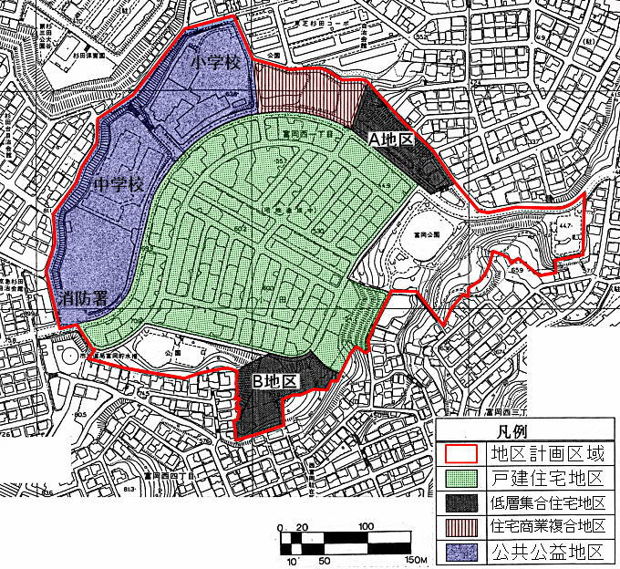
 Plan drawing (division of district)
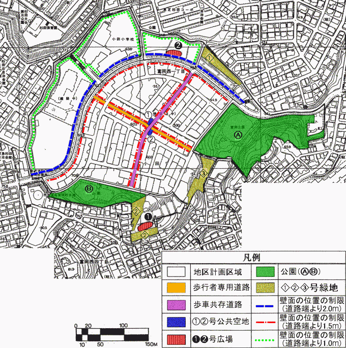
 Plan drawing (location of district facilities, restrictions on wall position)
| Name | Kanazawa Tomioka Nishi 1-chome Residential Area District Planning | |
|---|---|---|
| Position | 8-chome Sugita, Isogo-ku, Yokohama-shi and Tomioka-Nishi 1-chome, Tomioka-Nishi 3-chome and Tomioka-Nishi 4-chome, Kanazawa-ku | |
| Area | Approx. 15.7ha | |
| Ward Areas No 1. Bill ・ Opening Departure Oh Bi Hoping All No Sir Needle |
Targets of District Planning | Tomioka Nishi 1-chome Residential Area is located on a hill overlooking the sea in the southern part of Yokohama City, about 800m west of Keikyu Tomioka Station in Keikyu. This district plan is based on a lush living environment in harmony with nature, and is based on the basic philosophy of creating a city that takes into account the view to the sea. The goal is to create a unique cityscape and a good living environment based on the policy of maintenance of district facilities and maintenance of buildings. |
| Land Use Policy | The entire area is divided into detached residential areas, low-rise apartment areas, residential commercial complexes and public utility areas. Detached residential area, low-rise apartment area and residential commercial complex area shall be in harmony with the surrounding area and shall be arranged according to the characteristics of each area. In the residential commercial complex, a commercial facility will be located in order to complement the convenience of the local residents, and a bus return point will be placed. In addition, public utilities (elementary and junior high schools) in harmony with the surrounding area and nature will be properly placed on the outer periphery of the district, and the green space on the site will be properly preserved. |
|
| Policy for the development of district facilities | In addition to maintaining a pedestrian-only road connecting the school and the park, the road that is orthogonal to the pedestrian-only road will be used as a community road for pedestrian coexistence, maintaining the coexistence of people and cars, eliminating utility poles, and considering the landscape. I do. In addition, a small plaza will be established at the intersection of pedestrian-only roads and community roads, and public vacant lots, parks, and plazas will be properly placed. At the same time, the greenery of the outer periphery of the district shall be properly placed as a preserved green space. | |
| Policy for maintenance of buildings, etc. | Single-family residential area Considering the landscape of the entire city from the top of the hill and the view to the sea, setting the necessary standards for maintaining and conservation as a detached residential area for use such as buildings, minimum floor area, height, restrictions on wall position, etc. 2 Low-rise apartment Area In order to secure an open space suitable for low-rise apartment and to create a living environment in harmony with the surrounding environment and nature, we will set the necessary standards for restrictions on the use of buildings, the minimum floor area, and restrictions on wall position. 3 Residential commercial complex Restrictions on uses such as buildings, minimum site area, in order to form a good living environment for middle and low-rise houses while reconciliation with commercial facilities and bus turn points to promote the convenience of residents. Set necessary standards for height and restrictions on wall position. 4 Public Interest Areas For elementary and junior high schools, the roof shall be covered, and consideration shall be given to the view to the sea and harmony with the surrounding environment. |
|
| c-012 District Development Plan (1) | ||||||
|---|---|---|---|---|---|---|
| Placement and scale of district facilities | Name | Scale | Remarks | |||
| Pedestrian-only roads | Width: 4.5m, length: 220m | As shown in the plan drawing | ||||
| Pedestrian Communal Road | Width: 6.5m, length: 270m | As shown in the plan drawing | ||||
| (1)Public vacant lots | About 100㎡ | As shown in the plan drawing | ||||
| (2)Public vacant lots | About 100㎡ | As shown in the plan drawing | ||||
| (1)Open space | About 150㎡ | Within Low-rise apartment (District B) | ||||
| (2)Open space | About 150㎡ | Within the residential commercial complex | ||||
| (1)Green Space | Approx. 1,800㎡ | As shown in the plan drawing | ||||
| (2)Green Space | Approx. 2,100㎡ | As shown in the plan drawing | ||||
| (3)Green Space | Approx. 2,400㎡ | As shown in the plan drawing | ||||
| (1)No. Park | Approx. 16,000㎡ | As shown in the plan drawing | ||||
| (2)No. Park | Approx. 7,000㎡ | As shown in the plan drawing | ||||
| c-012 District Development Plan (2) | ||||||
|---|---|---|---|---|---|---|
| Construction Construction Goods Etc. Ni Seki S L A matter Section |
Subdivision of the district | Detached residential area | Low-rise apartment area | Housing and Commerce Complex district |
Public Interest Areas | |
| District A | District B | |||||
| About 7.3ha | Approx. 0.8ha | Approx. 0.7ha | Approx. 0.8ha | About 3.6ha | ||
| Restrictions on Use of Buildings, etc. | Buildings other than the buildings listed in the following items must not be built. | |||||
| 1 Single-family homes 2 apartments with 2 units or 2 tenement house with 2 units 3 Single-family houses that also serve as clinics's purpose 4 Buildings necessary for the public interest or local community 5. Those attached to the buildings in each of the preceding items |
1 apartment house or tenement house 2 Buildings necessary for the public interest or in the community 3. Those attached to the buildings in each of the preceding items |
1 apartment house or tenement house 2 Stores, restaurants or coffee shops that sell goods 3 Barber shops, beauty salons and other similar service businesses 4 Breaders, confectioneries, and the like that engaged in the food manufacturing industry for self-sale 5 Study cram schools, flower arrangement classes, Go classes, and the like 6 Offices 7 clinics 8 Buildings necessary for the public interest or in the community 9 Those attached to the buildings in each of the preceding items 10 Buildings attached to the bus turnaround point |
1 Elementary school 2 Junior High School 3 Buildings necessary for the public interest 4 Those attached to the buildings in each of the preceding items |
|||
| Minimum site area of buildings | The site area of the building shall be 180 m2 or more. | The site area of the building shall be more than the area obtained by multiplying the number of dwelling units by 320m2. | The site area of the building shall be more than the area obtained by multiplying the number of dwelling units by 155m2. | The site area of the building shall be 160 m2 or more. However, the site area of a building with two or more dwelling units shall be 160 m2 or more, and shall be more than the area obtained by multiplying the number of dwelling units by 64 m2. | ―― | |
| Maximum height of buildings | 1 The height of the building must not exceed 10m (9m in the case of a site facing a pedestrian road and a pedestrian communal road). The height of the two houses must not exceed 9m. The height of each part of a building where the height of three houses is 7 m or less is 5 m obtained by multiplying the horizontal distance in the true north direction from each part to the center line of the front road or the boundary line of the adjacent land by 0.6. Must be less than the added one. The height of each part of a building where the height of the four houses exceeds 7m is 4m obtained by multiplying the horizontal distance in the true north direction from each part to the center line of the front road or the boundary line of the adjacent land by 0.5. Must be less than the one added. |
―― | 1 The height of the building must not exceed 15m. (2) The height of each part of the building shall be less than the one obtained by multiplying the horizontal distance in the true north direction from each part to the center line of the front road or the boundary of the adjacent land by 0.5 and adding 7m. Must. |
―― | ||
| Restrictions on the position of the wall | The outer wall of the building or the surface of the pillar in place of this shall not be constructed beyond the wall line from the road displayed in the plan drawing. In addition, the distance from the adjacent land boundary to the outer wall of the building or the surface of the pillar in place of this (hereinafter referred to as "retreat distance of the outer wall") Shall be 1 m or more. But it is not this limit when building or part of building in distance less than limit of retreat distance of outer wall corresponds to next kakugo. 1 The total length of the center line of the outer wall or pillar in place of this is 3m or less. 2 Storerooms and other similar uses (excluding car garages) Offer, the height of the eaves is 2.3m or less, and the total floor area is 5m2 or less. 3 The height of the eaves must be 2.3m or less in the car garage. |
The outer wall of the building or the surface of the pillar in place of this shall not be constructed beyond the wall line from the road displayed in the plan drawing. In addition, distance from neighboring land boundary line to outer wall of building or surface of pillar in place of this assumes more than 1m. | ||||
| Restrictions on the form or design of buildings | The roof of the building shall be such a roof (excluding school rooftop pools, etc.), and the roof of the building, the outer wall, and other parts viewed from the outside shall not be used in order to maintain the landscape of the district well. I do. In addition, for outdoor advertising materials, stimulating colors and decorations shall not be used. | |||||
| Restrictions on the structure of a fence or fence | Hedges or fences with openness. | |||||
Inquiries to this page
Urban Development Bureau Regional Town Development Department Regional Town Development Division
Telephone: 045-671-2667
Telephone: 045-671-2667
Fax: 045-663-8641
Email address: tb-chiikimachika@city.yokohama.jp
Page ID: 885-550-467


