


- Yokohama-shi Top Page
- Midori Ward Top Page
- Disaster Prevention and anti-crime program
- Disaster Prevention and Disasters
- Immediately upon the announcement of sediment-related disaster warning information in Midori Ward, evacuation warning Target Area, Flood, Inland Water and Sediment Hazard Map
Here's the text.
Immediately upon the announcement of sediment-related disaster warning information in Midori Ward, evacuation warning Target Area, Flood, Inland Water and Sediment Hazard Map
Last Updated December 20, 2024
1 location in evacuation warning immediately upon the announcement of landslide warning information in Midori Ward
Based on the lessons learned from Typhoon No. 18 in October 2014, Yokohama City decided to extract cliffs that could cause significant damage to houses in the event of a landslide, and to issue a "evacuation warning" with the announcement of "Earthquake Disaster Warning Information" to the surrounding area.
There is one target area in Midori Ward.
It does not mean that the area where evacuation warning has not been issued is safe. In the event of a heavy rain or typhoon, pay attention to disaster prevention information and take evacuation actions as soon as possible at your own discretion.
Part of Terayamacho (map) (outside site)
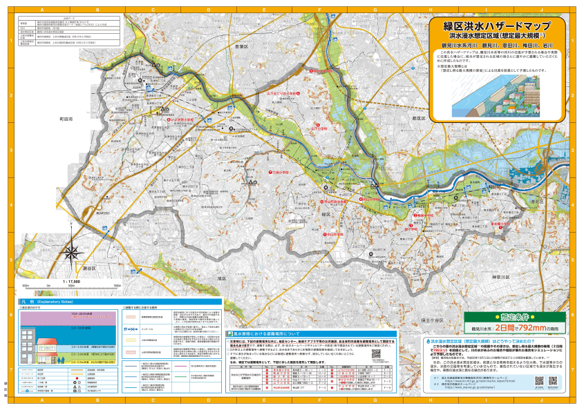
Flood Hazard Map (Flood, Inland Water, Earthquake)
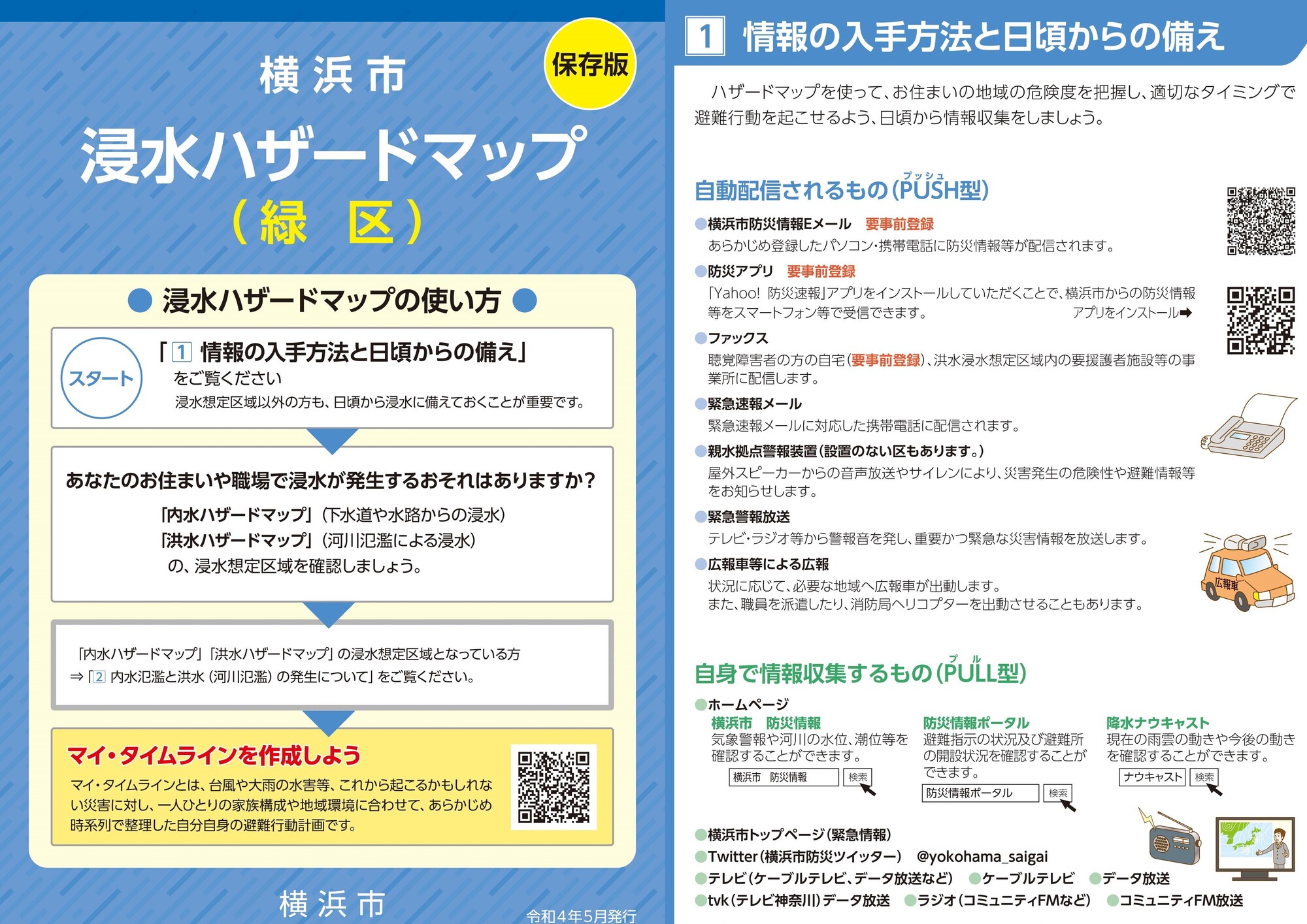
Inundation hazard map cover, information surface (PDF: 6,818KB)
Flood Hazard Map (PDF: 9,354KB)
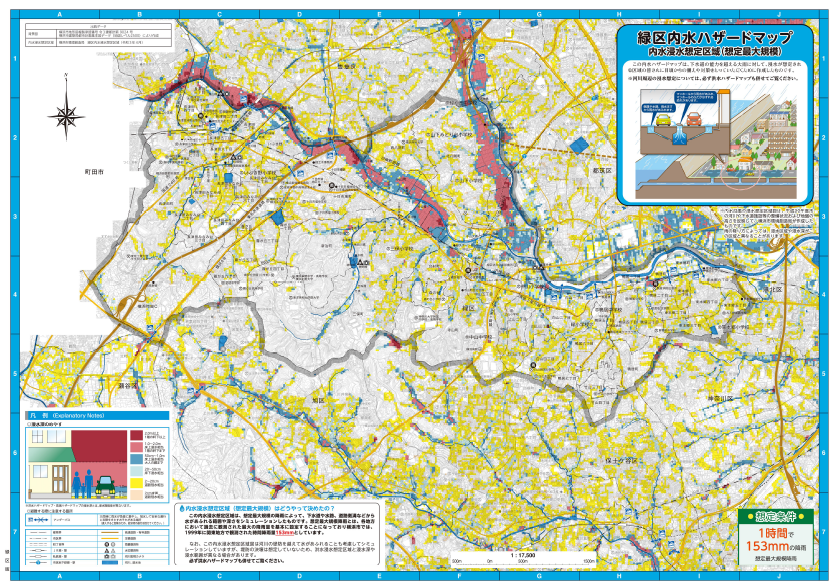
Inland water hazard map (PDF: 9,469KB)
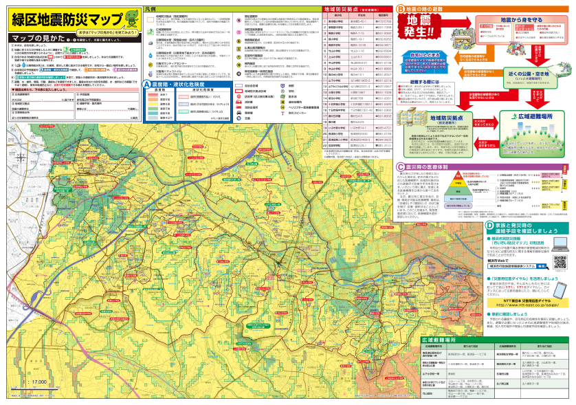
Earthquake Disaster Prevention Map (PDF: 6,818KB)
Download
Disaster prevention map, hazard map, disaster preparedness plan
Flood Hazard Map
Areas where flooding is expected due to heavy rain or river flooding caused by torrential rainfalls and their evacuation sites are posted.
・Published and revised: Published in May 2022
・Planning and issuance (reference): General Affairs Bureau Regional Disaster Prevention Section (Phone: 045-671-3456 / FAX: 045-641-1677)
・Distribution location: Midori Ward Office 1F General Information, 4F General Affairs Division
Inland water hazard map
Information on inundation areas and water depths caused by sewers and waterways caused by heavy rains and torrential rainfalls
・Published and revised: Published in May 2022
・Planning and issuance: Sewerage River Bureau Management Promotion Section (Phone: 045-671-2838 / FAX: 045-664-0571)
・Distribution location: Midori Ward Office 1F General Information, 4F General Affairs Division
Earthquake disaster prevention map
Assuming the occurrence of the Genroku era-type Kanto Earthquake, post evacuation behavior in the event of a major earthquake and how to view maps.
・Issued: Revision: Published in May 2022
・Planning and issuance: Midori Ward General Affairs Division (Tel: 045-930-2208/FAX: 045-930-2209)
・Distribution location: Midori Ward Office 1F General Information, 4F General Affairs Division
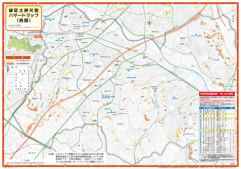
Earth and Sand Disaster Hazard Map (East and West)
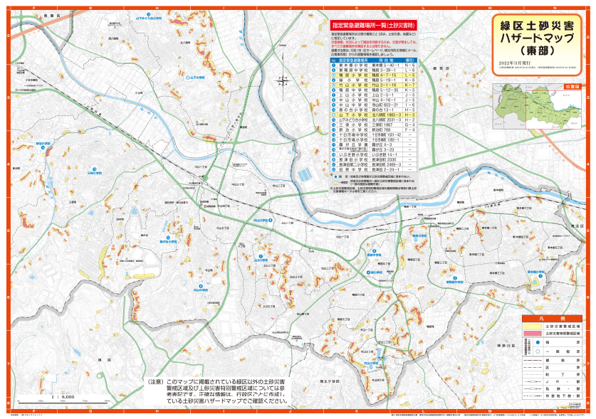
Earth and sand disaster hazard map (eastern part) (PDF: 23,398KB)
Earth and sand disaster hazard map (western part) (PDF: 23,130KB)
Download
Disaster prevention map, hazard map, disaster preparedness plan
Earth and Sand Disaster Hazard Map (East and West)
Areas where landslides are expected to be caused by heavy rains and torrential rainfalls, as well as evacuation sites
・Published and revised: Published in March 2022
・Planning and issuance (reference): Housing and Architecture Bureau Building Disaster Prevention Section (Phone: 045-671-2948 / FAX: 045-663-3255)
・Distribution location: Midori Ward Office 1F General Information, 4F General Affairs Division
You may need a separate PDF reader to open a PDF file.
If you do not have it, you can download it free of charge from Adobe.
![]() To download Adobe Acrobat Reader DC
To download Adobe Acrobat Reader DC
Inquiries to this page
Midori Ward General Affairs Division
Telephone: 045-930-2208
Telephone: 045-930-2208
Page ID: 317-096-427


