・Plan| Name | Tsunashima Higashi 1-chome District Planning |
|---|
| Position | Tsunashima Nishi 1-chome, Tsunashima Higashi 1-chome and Tsunashima Higashi 2-chome ground, Kohoku-ku |
| Area | Approx. 4.4ha |
| Targets of District Planning | This area is located in front of the East Exit Station of Toukyu Toyoko Line Tsunashima Station and has a new station on the Sotetsu-Tokyu Line.
In the vicinity of East Exit Tsunashima Station, including the area, buses and taxis are concentrated in front of the station, but the function of the station and the pedestrian space are insufficient, causing the traffic environment around the station to deteriorate. Therefore, the development of urban infrastructure such as buses and taxis and roads that meet the demand of station users, and the development of pedestrian spaces have become important issues. In addition, since a new station on the Sotetsu / Tokyu Direct Line will be developed, there is a need for the development of pedestrian spaces for new station users and the promotion of land use that takes advantage of the new location characteristics of the station square.
Under the Kohoku Ward Plan of Yokohama City Urban Planning Master Plan, the Tsunashima area is positioned as a living base that forms efficient and convenient urban areas by accumulating functions such as commerce, living services, welfare, etc., centering around stations, according to the population size and composition ofKohoku Ward.
According to the regional town development policy, in the Tsunashima area, measures to ensure the safety of pedestrians mainly around stations, around elementary schools, main roads and major regional roads, and to increase the safety of crossing the Tsunashima Kaido are considered. I'm doing it. With the construction of a new station, Tsunashima Station East Exit will reorganize bus and taxi platforms to create an environment where cars can pass smoothly and develop bicycle parking lots in line with the demand of bicycle users. In addition, it is decided to guide land use appropriate for the station square, taking advantage of the potential around the station, and commercial and business functions are mainly used for land use, and housing etc. coexist. In this district plan, we aim to improve convenience around the station, maintain a safe pedestrian space, guide land use that takes advantage of location characteristics, and promote sustainable and attractive town development suitable for the SDGs future city, Yokohama Aim. |
Ward
Areas
No
1.
Bill
・
Opening
Departure
Oh
Bi
Hoping
All
Ni
Seki
S
L
Sir
Needle | Land Use Policy | 1 In order to strengthen the functions around the station, reorganize the platform for buses, taxis, etc., and improve the urban infrastructure such as roads to improve the convenience of users around the station and around the station, and provide safe and comfortable pedestrian We will create a space and guide a building plan that considers the pedestrian environment.
3.4.21 Tokyo Maruko Yokohama Line (Tsunashima Kaido), 3.4.21, Tsunashimahigashi Line, 3.4.55, Tsunashima Hiyoshi Line, 3.5.12, Tsunashima Hiyoshi Line, and city planning parking lot Develop a bicycle parking lot. In addition, we will promote the development of three-dimensional crossing facilities that can safely cross the Tsunashima Kaido.
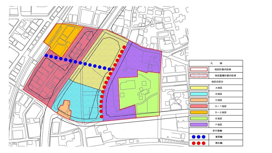
Within the three main areas, the axis connecting the station square of Tsunashima Station East Exit and the new station (the east-west axis) and the axis on the Tsunashimahigashi line (the north-south axis) are formed to create a new flow of people in the area. In addition, a central plaza will be placed in the center of the Area, and multiple plazas will be maintained in cooperation with pedestrian shafts.
4 While taking advantage of the regional characteristics of the Tsunashima area, land use that takes into account global warming countermeasures such as energy conservation, landscape harmony with the surrounding area, consideration for the local environment through greening, improvement of local disaster prevention and barrier-free, etc. I do.
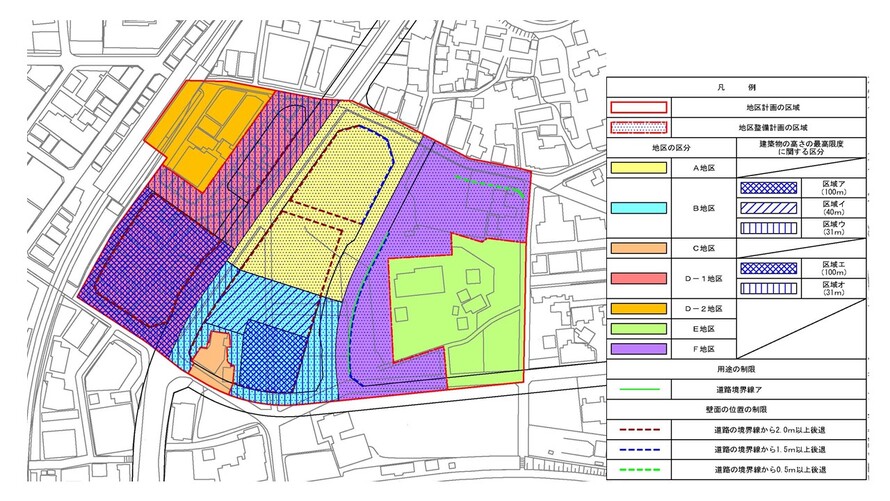
5 In order to form a good urban area suitable for regional bases, the districts are divided according to location characteristics, and the land use policy is determined as follows.
(1) District A
Through the land readjustment project, the urban infrastructure around the new station will be improved, and functions such as commerce, business, and urban housing will be integrated based on the high accessibility sandwiched between the two stations.
(2) District B
Through the land readjustment project, we will improve the urban infrastructure around the new station and, based on the high accessibility between the two stations, aim to rational and sound advanced use of land and renew urban functions. We will implement redevelopment projects and develop commercial, business, urban housing, etc. in consideration of convenience and liveliness, as well as the inhabitant of a ward cultural center that will serve as a base for local culture and artistic activities.
In addition, in order to reduce the burden on the environment and create an attractive urban landscape, we will actively promote greening on the premises.
(3) District C
Taking advantage of the convenience as a station square, we aim to locate urban-type houses that are in harmony with the surrounding environment.
(4) D-1 District
Based on the high accessibility between the two stations, we will implement an urban redevelopment project to promote rational and sound advanced use of land and renewal of urban functions, and commercial, business, urban areas that create convenience and liveliness In addition to accumulating functions such as housing, a traffic plaza will be developed as a boarding point for taxis and general vehicles in front of Tsunashima Station to secure a safe pedestrian space.
In addition, in order to reduce the burden on the environment and create an attractive urban landscape, we will actively promote greening on the premises.
(5) D-2 Districts
Taking advantage of the convenience as a station square, we aim to locate commerce, business, urban housing, etc. in harmony with the surrounding environment.
(6) Area E
Properly arrange historical assets, green spaces, farmland, etc. in harmony with the surrounding land use.
(7) District F Through the land readjustment project, the urban infrastructure around the new station will be maintained, and stores, offices in harmony with the E district and surrounding residential areas will be integrated with the A and B districts to form a lively area along the pedestrian axis. , Locations such as houses. |
| Policy for the development of district facilities | A divided road will be maintained on the east side of the district to secure a safe pedestrian space.
Appropriately arrange station facilities such as new station entrances and entrances to bicycle parking lots, and arrange plazas to secure pedestrian spaces and pool spaces for railway and bus users and users around the station. About central open space, we maintain space suitable for center of lively and interchange of the whole district. About open space 1, we maintain space where lively and rest coexist. About open space 2, we secure pedestrian space more than width 3.0m while maintaining space becoming place of interchange by united with low-rise part of neighboring building and forms lively. About open space 3, we maintain space becoming entrance of the north side of district and maintain space where pedestrian of Tsunashima Kaido passes safely and can stay.
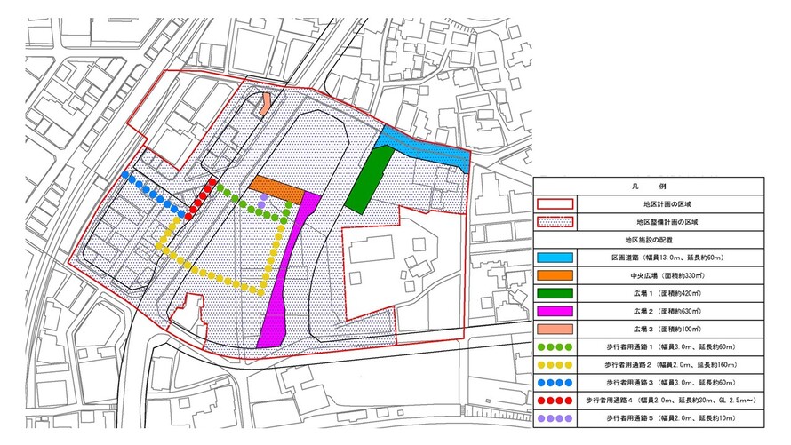
In order to form a safe and comfortable pedestrian space, develop sidewalk-like open space. In order to safely cross the Tsunashima Kaido and create a comfortable and migratory pedestrian network, we will develop pedestrian passages from Tsunashima Station East Exit Station to the new station and central square. |
| Policy for maintenance of buildings, etc. | 1 While considering the surrounding urban environment, we plan to guide buildings in line with the land use policy.
2 In order to form a good urban area suitable for the base stipulated in the land use policy, depending on the characteristics of the district, restrictions on the use of buildings, restrictions on the position of walls, the maximum height of buildings, buildings, etc. Define restrictions on form designs such as buildings and the minimum greening rate of buildings.
3 In order to create a lively atmosphere suitable for the station square base, buildings in District A, District B and District D-1 will guide commercial and business facilities to the low-rise area facing the pedestrian axis and pedestrian passages. In addition, the building on the south side of the F district will guide stores, offices, etc. to the low-rise area facing the north-south axis.
4 Buildings to be developed through urban redevelopment projects in District B and District D-1 will be designed with high energy-saving performance, introduce efficient building equipment, and promote the management of energy information.
5 In order to create a safe urban space that is resistant to disasters, buildings maintained by urban redevelopment projects in District B and D-1 have high earthquake resistance, disaster prevention functions, and take measures to prevent dangers such as falling objects. Shall be.
Buildings maintained by the urban redevelopment project in 6 B and D-1 districts shall be facilities that take into account barrier-free for users from the viewpoint of welfare town development. 7 In order to form a landscape suitable for the face of a new city accompanying the location of the new station, the buildings in the A district, B district, D-1 district and F district face the north-south axis while harmonizing the landscape. The building shall be a form design that creates the bustle of the low-rise part. |
| Greening Policy | Greening is performed as follows to form moisture and attractive urban landscape.
1 Priority will be given to planting, including Takagi, in places where the gaze at the above ground gathers, and greening with high visibility from the surrounding area will be promoted and an open greening space will be created.
2 Create a lively greening space along the east-west axis and the north-south axis, such as various plantings that make you feel the season and arrangement of symbol trees. 3 In Area F, based on the fact that it is adjacent to local resources such as green spaces and agricultural lands in Area E, we will create a continuous greening space centered on roadside areas, such as by using trees with a sense of quantity. |
・Plan (Continued)| District maintenance plan |
|---|
Of district facilities
Placement and
Scale | Divided roads | Width 13.0m extension about 60m |
| Central Plaza | Area approximately 330m2 |
| Square 1 | Area approximately 420m2 |
| Square 2 | Area approximately 630m2 |
| Square 3 | Area approximately 100m2 (partially non-blue sky) |
| Sidewalk-shaped open space 1 | Width 2.0m extension Approx. 510m (partial non-blue sky) |
| Sidewalk-shaped open space 2 | Width 1.5m extension about 180m |
| Sidewalk-shaped open space 3 | Width 0.5m extension about 50m |
| A passage for pedestrians 1 | Width 3.0m extension about 60m (partially non-blue sky) (to be connected to the new station) |
| A passage for pedestrians 2 | Width 2.0m extension Approx. 160m (partial non-blue sky) |
| A passage for pedestrians 3 | Width 3.0m extension 60m (partially non-blue sky) |
| A passage for pedestrians 4 | Width 2.0m extension about 30m (some non-blue sky), GL2.5m ~ |
| A passage for pedestrians 5 | Width 2.0m extension about 10m (partially non-blue sky) (it shall lead to central square) |
Construction
Construction
Goods
Etc.
Ni
Seki
S
L
A matter
Section | District
Category | Name | District A | District B | D-1 District | District F |
Area | Approx. 0.8ha | Approx. 0.6ha | Approx. 0.9ha | Approx. 0.9ha |
| Restrictions on the use of buildings | The following buildings must not be constructed. 1. The first floor is used for housing (excluding corridors, halls, stairs, elevators, and the like that are only used for housing on the first floor.) 2 Public baths pertaining to the bathing business with private rooms and other similar buildings stipulated in Article 130-9-5 of the Building Standards Law Enforcement Ordinance (Government Ordinance No. 338 of 1950) 3 Driving Schools 4 Those to be used for storage or disposal of dangerous goods (excluding storage facilities for own use and other similar ones) | The following buildings must not be constructed. 1. The first floor is used for housing (excluding corridors, halls, stairs, elevators, and the like that are only used for housing on the first floor.) 2 Cabarets, restaurants and the like 3 Public baths pertaining to the bathing business with private rooms and other similar items prescribed in Article 130-9-5 of the Building Standards Law Enforcement Order 4 Majang, Pachinko, shooting range, Katsuma voting ticket sales office, off-site ticket sales office, and the like 5 Warehouses engaged in warehousing business 6 Factories (excluding those attached to stores, restaurants, and other buildings used for similar purposes) 7 Driving Schools 8 Livestock barns of the scale prescribed in Article 130-7 of the Building Standards Law Enforcement Order 9 Those to be used for storage or disposal of dangerous goods (excluding storage facilities for own use and other similar ones) | The following buildings must not be constructed. 1. The first floor is used for housing (excluding corridors, halls, stairs, elevators, and the like that are only used for housing on the first floor.) 2 Public baths pertaining to the bathing business with private rooms and other similar items prescribed in Article 130-9-5 of the Building Standards Law Enforcement Order 3 Majongya, shooting place, Katsuma voting ticket sales place, off-site ticket sales floor and off-site Katsufune voting ticket sales office 4 Warehouses engaged in warehousing business 5 Factories (excluding those attached to stores, restaurants, and other buildings used for similar purposes) 6 Driving Schools 7 Livestock barns of the scale prescribed in Article 130-7 of the Building Standards Law Enforcement Order 8 Those to be used for storage or disposal of dangerous goods (excluding storage facilities for own use and other similar ones) | The following buildings must not be constructed.
1 On the site adjacent to the road boundary a shown in the plan drawing, the first floor is used for housing (the part provided for the first floor house is only corridors, halls, stairs, elevators, and the like) Excluding those.)
2 Driving School 3 Those to be used for storage or disposal of dangerous goods (excluding storage facilities for own use and other similar ones) |
| Restrictions on the position of the wall | The outer wall of the building or the surface of the pillar in place of this shall not be built beyond the limit of the position of the wall shown in the plan drawing. But it is not this limit when building or part of building in distance less than limit of this distance corresponds to any of next kakugo. 1 Public corridors 2 Elevators, escalators, stairs or slopes for moving up and down to public walkways | The outer wall of the building or the surface of the pillar in place of this shall not be built beyond the limit of the position of the wall shown in the plan drawing. But it is not this limit when building or part of building in distance less than limit of this distance corresponds to any of next kakugo. 1 Public corridors 2 Elevators, escalators, stairs or slopes for moving up and down to public walkways | The outer wall of the building or the surface of the pillar in place of this shall not be built beyond the limit of the position of the wall shown in the plan drawing. But it is not this limit when building or part of building in distance less than limit of this distance corresponds to any of next kakugo. 1 Public corridors 2 Elevators, escalators, stairs or slopes for moving up and down to public walkways | The outer wall of the building or the surface of the pillar in place of this shall not be built beyond the limit of the position of the wall shown in the plan drawing. |
| Maximum height of buildings | The height of the building must not exceed 31m. However, if the site area of the building is 300m2 or more, it can be 45m or less. | The height of the building must not exceed 100m in Area A shown in the plan drawing, 40m in Area A, and 31m in Area C. | The height of the building must not exceed 100m in area d shown in the plan drawing and 31m in area o. | ― |
| Restrictions on form design of buildings, etc. | 1 The form design of the building shall conform to the following matters in order to consider the landscape harmony to the surroundings.
(1) The colors of the building shall be in harmony with the colors of the surrounding buildings. (2) Buildings with a height of more than 31m shall be divided by color at the height of the building of 31m or less, and the base color of the high-rise area shall be higher in brightness than the base color of the low-rise area. | 1 The form design of the building shall conform to the following matters in order to consider the landscape harmony to the surroundings. Provided, however, that the provisions of No. 5 and No. 6 shall not apply to public toilets, police officers, and other similar buildings necessary for the public interest.
(1) The colors of the building shall be in harmony with the colors of the surrounding buildings.
(2) The color of the part of the building with a height of more than 31m shall be based on a monthly color system with a brightness of 5 or more and a saturation of 4 or less in the Munsell color system.
(3) Buildings with a height of more than 31m shall be divided by color at the height of the building of 31m or less, and the base color of the high-rise area shall be higher in brightness than the base color of the low-rise area.
(4) The part where the height of the building exceeds 20m is divided by the design and color of the pillars of the building so that the high-rise building in the area a shown in the plan and other parts of the building can be seen as a separate building, The horizontal length projected on the lead surface of each part must be 70m or less.
(5) In order to reduce the sense of longness due to the wall of the building, a form design that separates the wall according to the design and color of the pillars, etc.
(6) The first floor part facing the open space 2 of the building shall be a form design that allows you to see the activities inside the building and liveliness, such as providing an opening.
2 Outdoor advertising materials shall conform to the following matters so as not to obstruct the landscape of the district and the landscape from outside the district. Provided, however, that this shall not apply to information signs and other items that are deemed necessary to be installed for public purposes.
(1) Outdoor advertising materials (excluding those that display independent characters, marks, etc. in their own name, contents of their own business or business, or those that display necessary items for management) are more than 31m in height of buildings Do not be provided.
(2) Lighting of outdoor advertising materials should avoid excessive ones and do not install anything that flashes light sources.
3 Building equipment installed outdoors (excluding solar power generation equipment or solar heat utilization equipment) shall not have a messy appearance, such as shielding so that it is not easily seen from the surroundings.
4 The parking lot or bicycle parking lots shall not have a messy appearance, such as planting or other appropriate shielding. | 1 The form design of the building shall conform to the following matters in order to consider the landscape harmony to the surroundings. Provided, however, that the provisions of item 5 shall not apply to public toilets, police officers, and other similar buildings necessary for the public interest.
(1) The colors of the building shall be in harmony with the colors of the surrounding buildings.
(2) The color of the part of the building with a height of more than 31m shall be based on a monthly color system with a brightness of 5 or more and a saturation of 4 or less in the Munsell color system.
(3) Buildings with a height of more than 31m shall be divided by color at the height of the building of 31m or less, and the base color of the high-rise area shall be higher in brightness than the base color of the low-rise area.
(4) For parts where the height of the building exceeds 20m, the horizontal length projected on the lead surface of the building part must be 70m or less.
(5) In order to reduce the sense of longness due to the wall of the building, a form design that separates the wall according to the design and color of the pillars, etc.
2 Outdoor advertising materials shall conform to the following matters so as not to obstruct the landscape of the district and the landscape from outside the district. Provided, however, that this shall not apply to information signs and other items that are deemed necessary to be installed for public purposes.
(1) Outdoor advertising materials (excluding those that display independent characters, marks, etc. in their own name, contents of their own business or business, or those that display necessary items for management) are more than 31m in height of buildings Do not be provided.
(2) Lighting of outdoor advertising materials should avoid excessive ones and do not install anything that flashes light sources.
3 Building equipment installed outdoors (excluding solar power generation equipment or solar heat utilization equipment) shall not have a messy appearance, such as shielding so that it is not easily seen from the surroundings. 4 The parking lot or bicycle parking lots shall not have a messy appearance, such as planting or other appropriate shielding. | 1 The colors of the buildings shall be in harmony with the colors of the surrounding buildings in order to consider the landscape harmony to the surroundings. |
| Minimum of greening rate of buildings | 7.5/100 | 10/100 | 10/100 | 15/100 |