


Here's the text.
C-041: Area around Niwa Station
※The plan reads out statutory books in the form of a table, and it may be difficult to understand the contents. Please contact the Urban Revitalization Division for confirmation of the contents (Phone number: 045-671-3858)
Last Updated November 1, 2021
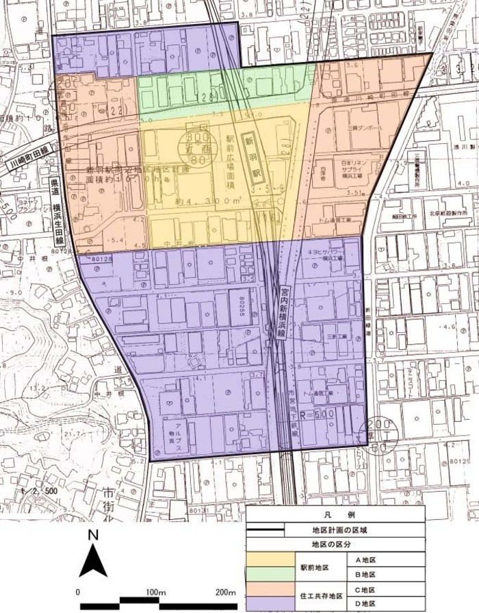
Plan drawing (division of district)
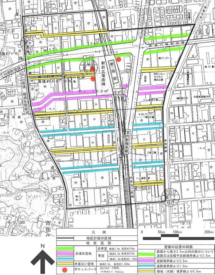
Plan drawing (restrictions on position of district facilities and wall surfaces)
| Name | Niwa Station Area District Plan | ||
|---|---|---|---|
| Position | Nippacho, Kouhoku-ku, Yokohama-shi | ||
| Area | About 20.0ha | ||
| Ward Areas No 1. Bill ・ Opening Departure Oh Bi Hoping All No Sir Needle |
Targets of District Planning | This area is positioned as a part of central Shin-Yokohama, and it is expected that the location of housing and commercial facilities will increase in the future due to the opening of Municipal Subway Line 3 and the development of urban planning roads. In particular, around Niiba Station, various functions that support the activities of the city center, such as commerce, business, and services, are planned to accumulate, and it is necessary to create an environment where activities such as "living" and "working" coexist and harmonize. . In this district plan, in order to promote the creation of a town suitable for the station square, which is part of the city center of Shin-Yokohama, advanced use of land will be planned, commercial and business facilities and urban housing will be located, and houses and factories will coexist. The goal is to create a harmonious and good environment. |
|
| Land Use Policy | We divide into station square district (A district, B district), residential and industrial coexistence district (C district, D district), and guide land use according to the following policies.
|
||
| Policy for the development of district facilities | In order to secure a safe and comfortable walking space to the station, maintain a sidewalk-like open space. In the station square area, pocket parks and open spaces along the sidewalk will be maintained as a comfortable space where local residents and station users are crowded and relax. |
||
| Policy for maintenance of buildings, etc. |
|
||
| Greening Policy | Active greening on the premises will be promoted in order to create a moist cityscape and create a favorable coexistence environment for housing and engineering. | ||
| District maintenance plan | ||||||
|---|---|---|---|---|---|---|
| Placement and scale of district facilities | Sidewalk-like open space | Width 2.5m extension approximately 1,290m | ||||
| Width 1.0m extension Approx. 1,100m | ||||||
| Open space along the sidewalk | Width 0.5m extension Approx. 2,310m | |||||
| Pocket park | Approx. 210m2 (3 locations, 70m2 or more per location) | |||||
| Construction Construction Goods Etc. Ni Seki S L A matter Section |
Classification of district | Name | District A | District B | District C | District D |
| Area | 3.2ha | 1.3ha | 5.5ha | 10.0ha | ||
| Restrictions on the use of buildings | Buildings listed in the following items shall not be constructed.
|
Buildings listed in the following items shall not be constructed.
|
||||
| Maximum floor area ratio of buildings | The ratio of the total area of the building to be used for the house or the part to be used for the house (including facilities such as elevators attached to the part) of the building, including the part to be used for the house, to the site area The maximum limit is 20/10. | - | ||||
| Minimum site area of buildings | 700m2 | 500m2 | 200m2 | |||
Provided, however, that this shall not apply to land that falls under any of the following.
|
||||||
| Restrictions on the position of the wall | The outer wall of the building or the surface of the pillar in place of this shall not be built beyond the limit of the position of the wall shown in the plan drawing. |
|
||||
| Maximum height of buildings | The height of the building must not exceed 31m. |
|
- | |||
| Restrictions on forms or designs of buildings, etc. | The colors of the roof and outer walls of the building and the colors, sizes and shapes of outdoor advertising materials shall be in harmony with the landscape of the district. | |||||
| Restrictions on the structure of a fence or fence | The structure of the fence or fence facing the road shall have hedges, fences and similar openness. However, this excludes fence foundations, gateposts, gates and the like. |
- | ||||
Inquiries to this page
Urban Renewal Division, Urban Development Bureau Urban Renewal Department
Telephone: 045-671-3858
Telephone: 045-671-3858
Fax: 045-664-3551
Email address: tb-tosai@city.yokohama.jp
Page ID: 107-778-590


