Here's the text.
S-004: Nishi area of Shinkoyasu Station
City planning decision: April 8, 1997
Last Updated December 9, 2022

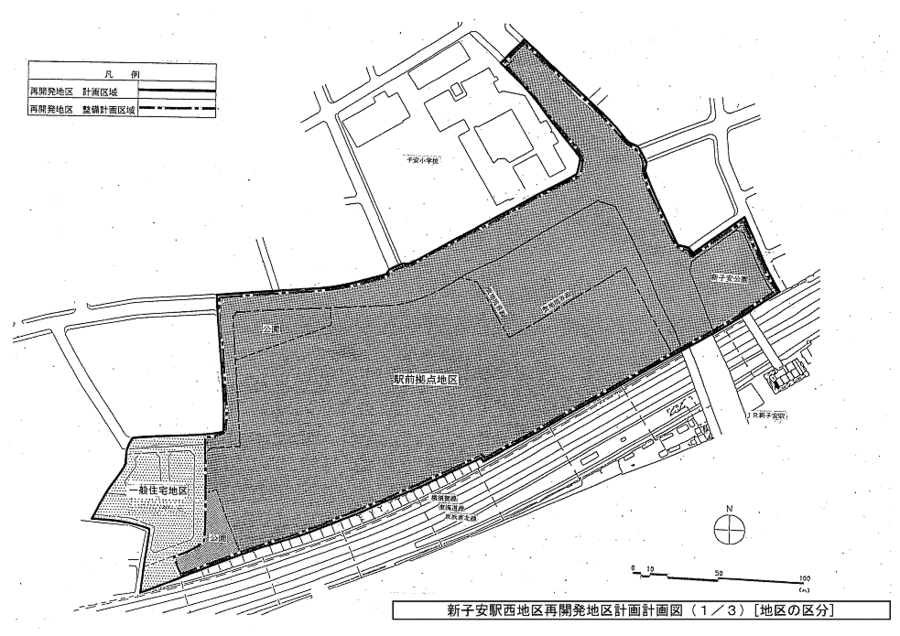
Plan drawing (division of district)

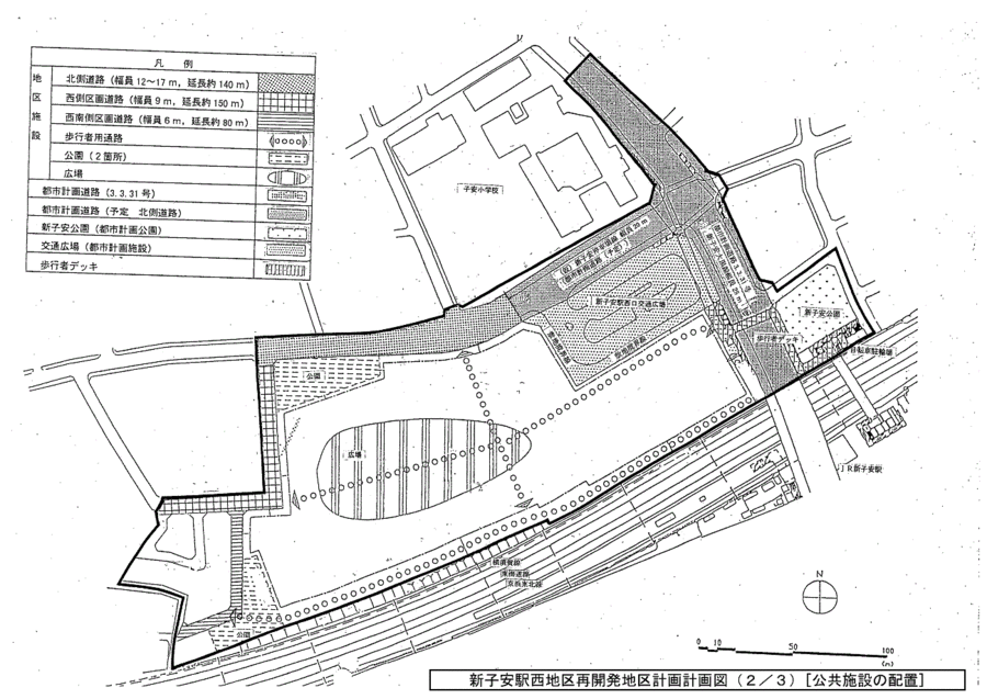
Plan drawing (location of district facilities and public facilities)

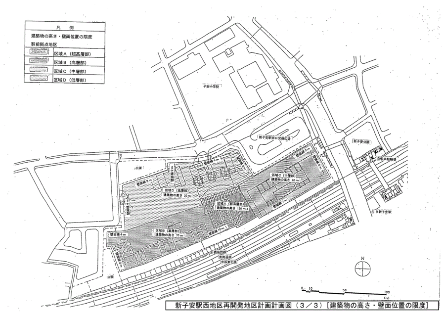
Plan drawing (restrictions on the height of the building and the position of the wall)
| Name | Shinkoyasu Station West Area Redevelopment District Plan | |||||||
|---|---|---|---|---|---|---|---|---|
| Position | 1-chome Irie-chome and 1-chome Shinkoyasu, Kanagawa-ku, Yokohama-shi | |||||||
| Area | About 4.6ha | |||||||
| Ward Areas No 1. Bill Oh Bi Opening Departure Ni Seki S L Sir Needle |
Targets of redevelopment district planning | The planned area is adjacent to JR Keihin Tohoku Line and Shinkoyasu Station in Keihinkyuko Line, and is positioned as a regional base in the Yumehama 2010 Plan. This redevelopment district plan ensures the development of urban infrastructure such as roads, traffic plazas, parks, etc., and the development of public facilities such as strengthening the pedestrian network with decks, etc. By promoting the advanced use of land while harmonizing with residential areas, we will introduce urban housing, business facilities, commercial service facilities, cultural and public facilities, and aim to play a leading role in regional base development. |
||||||
| Basic Policy on Land Use | Divide two districts and guide land use appropriate for each district. (Ekimae base area) ・Through urban redevelopment projects, we will develop urban infrastructure such as traffic plazas, roads, and parks, as well as create a comfortable pedestrian traffic network and create public spaces such as plazas and green spaces, as well as maintain the bicycle parking lots. ・We will introduce various uses such as commerce, business, living convenience facilities, sports facilities, citizen use facilities, and urban housing appropriate for the station square base area, and plan effective land use by arranging each three-dimensionally. ・Develop a sufficient amount of parking lots and bicycle parking facilities that meet the traffic demand in this area. (General residential area) ・We plan location such as houses in consideration of neighboring cityscape and try for tree planting and maintain good living environment. |
|||||||
| Maintenance policy for public facilities | 1 Improvement of urban environment and development of transportation infrastructure ・We establish traffic open space to perform city planning decision on the north side of station and perform linear improvement and widening maintenance of city planning road 3.3.31 Shinkoyasu Oguro Line and north side road of district. 2 Improvement of local environment and formation of pedestrian networks ・In order to separate pedestrians and eliminate pedestrian networks, pedestrian decks will be maintained as a continuous route from traffic square to station square. ・Urban planning park No. 2.2.203 Shinkoyasu Park and bicycle parking lots will be redeveloped. ・Effectively arrange north-south parks, plazas and green spaces, which are recreation spaces that are open to neighboring residents. ・To improve accessibility to the station area, secure passages in the district. |
|||||||
| Maintenance policy for buildings, etc. | ・ The plan will be to select colors and materials in harmony with the environment while taking advantage of the location characteristics that will be a landmark in the surrounding area, and to have a rich expression. In addition, in order to secure sunshine and ventilation in the surrounding area, create a plaza open to the local residents, and create a better cityscape, avoid uniform and monotonous layout of buildings, and create a tower-like skyline that gently overlaps with the landscape of the hilly area. ・ As a facility where people gather and come and go suitable for the station square base area, the plan will be considered in consideration of the formation of a lively and relaxing space. ・ For this reason, for the station square base district, restrictions on the use of buildings, the maximum ratio of the total area of buildings to the site area, the minimum ratio of the total area of buildings to the site area, the building area of buildings The maximum ratio of the ratio to the site area, the minimum building area of the building, the minimum floor area of the building, the limit of the position of the wall surface, the maximum height of the building, the building, the building, the building, the building, the building, the building, the building, the building, the building, the building, the building, the building, the building, the building, the building, the building, the building, the building, the limit of the limit of the building, the building, the limit of the limit of the limit of the limit of the building, the limit of the building, the limit of the structure or the structure of the building, the limit of the building |
|||||||
| Major public facilities Placement and scale of |
Pedestrian deck width 4m Approximately 85m in length (2 elevators) |
|||||||
| Development Area Development Plan | ||||||||||||||
|---|---|---|---|---|---|---|---|---|---|---|---|---|---|---|
| Position | 1-chome Irie-chome and 1-chome Shinkoyasu, Kanagawa-ku, Yokohama-shi | |||||||||||||
| Area | About 4.6ha | |||||||||||||
| Placement and scale of district facilities | Roads | Width | Extension | |||||||||||
| 12~17m | Approx. 140m | |||||||||||||
| 9m | Approx. 150m | |||||||||||||
| 6m | About 80m | |||||||||||||
| Aisles for pedestrians | 4m | Approx. 650m | ||||||||||||
| Park (2 places) | Approximately 2,000㎡ | |||||||||||||
| Open space | Approx. 5,000㎡ | |||||||||||||
| Construction Construction Goods Etc. Ni Seki S L A matter Section |
Classification of district | Name | Station base area | |||||||||||
| Area | About 4.2ha | |||||||||||||
| Restrictions on the use of buildings | Buildings listed in the following items shall not be constructed. 1 Shrines, temples, churches and the like 2 Public baths 3 Factories (excluding those attached to stores, restaurants, and other buildings used for similar purposes) 4 Driving Schools 5 Livestock barn 6 Those to be used for storage or disposal of dangerous goods (excluding storage facilities for own use and other similar ones) |
|||||||||||||
| Site of total floor area of buildings Maximum ratio to area |
40/10 | |||||||||||||
| Site of total floor area of buildings Minimum ratio to area Limit |
15/10 Provided, however, that this shall not apply to public toilets, police officers and other similar buildings that are necessary for the public interest. |
|||||||||||||
| Site of building area of building Maximum ratio to area Limit |
6/10 However, for buildings that fall under any of the items of Article 53, Paragraph 3 of the Building Standards Act (Act No. 201 of 1950), 1/10 is added, and buildings that fall under any of the items of the same paragraph Or, Paragraph 4, Item 1 of the same Article ※For buildings that fall under the category, 2/10 shall be added. |
|||||||||||||
| Minimum building area of buildings Limit |
200㎡ Provided, however, that this shall not apply to public toilets, police officers and other similar public interests. |
|||||||||||||
| Minimum site area of buildings Limit |
1,000㎡ Provided, however, that this shall not apply to public toilets, police officers, and other similar buildings that are used as sites for public interest. |
|||||||||||||
| Restrictions on the position of the wall | The outer wall of the building or the surface of the pillar in place of this shall not be built beyond the limit on the position of the wall shown in the plan drawing. Provided, however, that this shall not apply to elevators, stairs, slopes, and bicycle parking facilities for going up and down to public corridors and public corridors. |
|||||||||||||
| Maximum height of buildings | The height of the building in the area shown in the left column of the table below must not exceed the numerical value shown in the right column of the table below.
|
|||||||||||||
| Form or design of buildings Restrictions |
1 While taking advantage of the location characteristics that will be a landmark in the surrounding area, we will select colors and materials in harmony with the environment and have a rich expression. 2 The lower part of the building shall be a design that forms the liveliness of the pedestrian space around the plaza and the passageway. 3 High-rise buildings shall be tower-shaped in order to consider the impact on the surrounding area (sunshine, building style, feeling of oppression), and will be located from the center of the planned site. In addition, colors, forms and designs shall be harmonized with the surrounding environment. Buildings facing the northern road of the 4 districts will be low-rise, and by raising them step-by-step to balance the cityscape with the adjacent land. 5 The form of the building shall be a rhythmical design with changes in height and the position of the wall surface, and at the same time, the scale of the wall shall be divided and a plan with rich expressions and changes. About outdoor advertising matter to install in 6 buildings, we shall consider harmony with the surroundings after maintaining good cityscape scenery. |
|||||||||||||
| Restrictions on the structure of a fence or fence | Fences or fences shall be hedges, fences, and other similar openness and shall not impair the aesthetics, and shall be the minimum necessary for management. | |||||||||||||
※Due to the revision of the Building Standards Law (conducted on June 25, 2019), Article 53, Paragraph 4, Item 1 of the Building Standards Law listed in "The maximum building coverage ratio of buildings" is Article 53 of the Building Standards Law Has been revised to Paragraph 6, Item 1.
Inquiries to this page
Urban Development Bureau Regional Town Development Department Regional Town Development Division
Telephone: 045-671-2667
Telephone: 045-671-2667
Fax: 045-663-8641
Email address: tb-chiikimachika@city.yokohama.lg.jp
Page ID: 930-356-757


