


Here's the text.
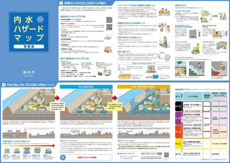
Inland water hazard map
Last Updated May 31, 2023
Inundation Hazard Map
Hazard maps for floods, inland waters and high tides are compiled into a single "Flood Hazard Map".
Please also check the information on the flood hazard map and the high tides hazard map along with the inland water hazard map.
What is an inland water hazard map?
It is a map that summarizes various information such as areas where inundation from sewer pipes and waterways is expected during heavy rain and depth of inundation.
This map is used to facilitate smooth evacuation actions against inundation and to raise awareness of disaster prevention during normal times.
Please refer to the following "PR videos" and "PR materials" for explanations of maps and how to use them.
PR video ⇒ "Preparing for heavy rain-Utilization of inland water hazard map-(outside site)"
PR document ⇒ "Let's prepare for the increasing heavy rain using inland water hazard map! (PDF:1,317KB)」
※Inland water: Heavy rain fills sewer pipes and waterways, and water overflows from manholes and rainwater masu.
※Flood: Heavy rain continues to rise, the water level of the river rises, exceeding the embankment or breaking the embankment, causing river water to overflow.
From June 28, 2021, it has been revised to an inland water hazard map when the largest possible rainfall (153 mm per hour) occurs.
Inspection of inland water hazard maps
Request for Use
When searching from Address, etc., and detailed drawings are available.
Please utilize "Yokohama-shi administration map reporting system (Wai Wai disaster prevention map) (outside site)".
・Residential land lower than roads, such as basements and underground parking lots, may have a risk of rainwater entering regardless of the degree of flooding.
・Depending on the strength of the rain and how it falls, the flooded area and inundation depth may differ from the assumption.
・The inundation assumption of the inland water hazard map is made reflecting the maintenance situation such as rivers and sewers at the end of 2018.
・The "Yokohama City Administrative Map Information Providing System (Wai Wai Disaster Prevention Map)" allows you to check the inundation depth of any point calculated by the inundation simulation as reference information and the ground height (TP) used for calculation. Please confirm "Click here (PDF: 1,028KB)" for confirmation method.
To residential land and building dealers
Due to a partial revision of the Enforcement Regulations of the Residential Land and Building Transaction Business Law (enforced on August 28, 2020), the location of the residential land or building subject to transaction in the flood hazard map created based on the Flood Control Law is newly described in the explanation of important matters. Will be positioned as an item.
The inland water hazard map of Yokohama City is not based on the Flood Control Law, but when dealing with residential land or buildings, present this inland water hazard map, and the other party of the transaction grasps the flood risk, and It is requested that you provide information on the location of the residential land and buildings subject to the transaction so that it can be used for evacuation actions.
Download inland water hazard map
Inland water hazard map information surface (PDF)
[Important Notice]
The inland water hazard map not only assumes water immersion in your area, but also uses water hazard maps.
・How to obtain necessary information in the event of a disaster and how to prepare on a daily basis
・Precautions for heavy rain and how to think about evacuation
・Mechanisms of inland flooding and flooding (river flooding)
・Actions to be taken when evacuation information is issued
It's important to note. Please be sure to check it along with the map.
↓↓↓Click here for download.↓↓↓
Inland water hazard map map (PDF)
| Name of administrative district | Inland water hazard map |
|---|---|
| Tsurumi Ward | |
| Kanagawa Ward | |
| Nishi Ward | |
| Naka Ward | Map surface (PDF: 7,956KB) Information (PDF: 5,660KB) |
| Minami Ward | |
| Konan Ward | |
| Hodogaya Ward | |
| Asahi Ward | |
| Isogo Ward | |
| Kanazawa Ward | |
| Kohoku Ward | |
| Midori Ward | |
| Aoba Ward | |
| Tsuzuki Ward | |
| Totsuka Ward | |
| Sakae Ward | |
| Izumi Ward | |
| Seya Ward |
※The map surface of each ward has been updated according to the content of the inundation hazard map (update date: June 1, 2022)
Inundation (inland water, flood, high tides) We have created a paper map as a hazard map. When you want reading on paper, please see in city hall the third floor citizen information room center.
Click here for the inundation hazard map
Others
Disasters in Yokohama City
(Flood history, etc. can be checked here.)
Frequently Asked Questions (PDF: 705KB)
(The content of frequently asked questions has been updated. Date of renewal: June 30, 2023
Past inland water hazard map
(Past inland water hazard maps can be found here.)
Inland water hazard map interview video (outside site)
(We interviewed National Research and Development Agency Institute of Disaster Prevention Science about inundation inland water.)
You may need a separate PDF reader to open a PDF file.
If you do not have it, you can download it free of charge from Adobe.
![]() To download Adobe Acrobat Reader DC
To download Adobe Acrobat Reader DC
Inquiries to this page
Sewerage River Bureau Management Promotion Department Management Promotion Section (plan)
Telephone: 045-671-2838
Telephone: 045-671-2838
Fax: 045-664-0571
Email address: gk-management@city.yokohama.lg.jp
Page ID: 794-254-996


