


Here's the text.
C-038: Myojindai district
City planning decision: September 5, 1997
Last Updated December 9, 2022
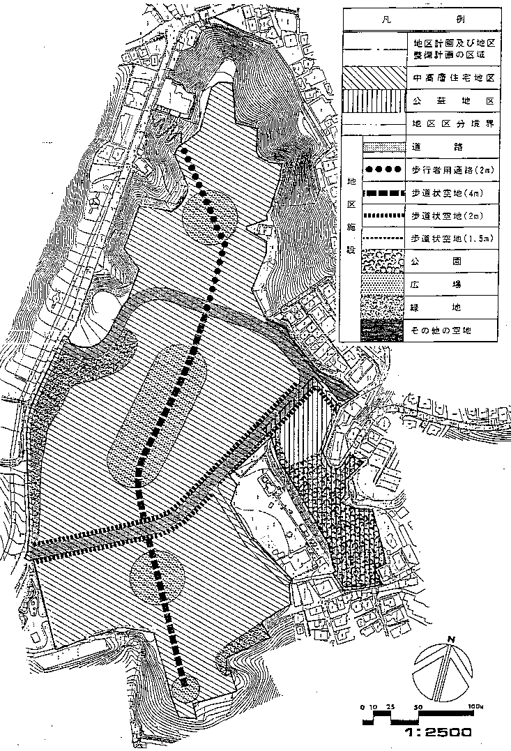
Plan drawing
| Name | Myojindai District Planning | |
|---|---|---|
| Position | Hanamidai and Myojin Plateau, Hodogaya-ku, Yokohama City | |
| Area | Approx. 9.0㏊ | |
| Ward Areas No 1. Bill ・ Opening Departure Oh Bi Hoping All No Sir Needle |
Targets of District Planning | This area is located approximately 500 meters west of Hoshikawa Station in Soutetsu Line, and is a housing complex developed by the Japan Housing Corporation (currently Housing and Urban Development Corporation) in 1959. Located on a lush hill adjacent to Prefectural Hodogaya Park, the surrounding slope green tracts are generally designated as urban green tracts and city planning parks, and are in a quiet district environment overlooking the city. The middle-rise houses in the district are aging because more than 30 years have passed since construction, and the living standard is extremely low. In addition, this area is positioned as an area that focuses on the supply of housing and residential areas under the Special Measures Law Concerning the Promotion of Supply of Housing and Residential Areas in metropolitan areas. It is a district that promotes improvement of the number of units and increase the number of units. Therefore, a rebuilding project will be implemented in order to redevelop the current middle-rise housing to achieve proper advanced use, and to supply high-quality housing that aims to improve the standard of living and renew its function as a residential area. I have. The purpose of this district plan is to plan a planned and efficient land use and a good living environment in the district, and to form a harmonious town Nami that takes into account the environment of the surrounding area. |
| Land Use Policy | The district is divided into two districts, a middle- and high-rise residential district and a public interest district, and land use is guided by the following policies.
Approximately 1,300 middle- and high-rise apartment houses will be located, meetinghouses, management offices, etc. will be arranged as appropriate, and stores and clinics will be consolidated into one location along the road in the central block to create a harmonious and favorable residential area.
In order to improve the convenience of local residents and nearby residents and create a good environment, we plan public interest use by parks and nursery schools. |
|
| Development policy for district facilities | ・In order to ensure the safety and convenience of traffic in this area, a divided street will be established. ・A comfortable plaza where local residents can relax will be arranged for each block, and a pedestrian space connecting them will be maintained. ・We establish park, green tract of land and other open space to plan improvement of local environment. |
|
| Policy for maintenance of buildings, etc. | In order to secure advanced use of land and open spaces such as open spaces, we plan to increase the rise of residential buildings. In addition, about maintenance of building, we give due consideration to influence on the surrounding environment such as sunshine, ventilation, scenery and make use of location of lush hill and raise building from the outskirts toward central axis from north to south. Create a good skyline. In addition, sufficient parking lots and bicycle parking lots will be secured according to the number of dwelling units. For this reason, restrictions on the use of buildings, the maximum ratio of the building area of buildings to the site area, the minimum floor area of buildings, restrictions on the position of walls, the maximum height of buildings, etc. Necessary standards shall be established in restrictions on forms or designs and restrictions on fences or fences. |
|
| Greening Policy | New construction slopes and open spaces on the outskirts of the area shall be greened to contribute to the green hill landscape conservation. In addition, existing trees will be preserved as much as possible along sidewalk-like open spaces and pedestrian passages, and street trees will be arranged as appropriate to provide comfortable shade for pedestrians. In addition, green residential areas will be formed by greening as much as possible between the buildings and the area around the parking lot. | |
| District maintenance plan | ||||||||||||||||
|---|---|---|---|---|---|---|---|---|---|---|---|---|---|---|---|---|
| Placement and scale of district facilities | Width | Extension | ||||||||||||||
| Roads | 10.5m | Approx. 590m | ||||||||||||||
| Aisles for pedestrians | 2.0m | Approx. 160m | ||||||||||||||
| Sidewalk-like open space | 4.Om | Approx. 340m | ||||||||||||||
| 2.Om | Approx. 520m | |||||||||||||||
| 1.5m | About 60m | |||||||||||||||
| Park | Area approximately 5,500 m2 | |||||||||||||||
| Open space | Area approximately 6,700 m2 | |||||||||||||||
| Green space | Area approximately 4,000 m2 | |||||||||||||||
| Other open space | Area approximately 500m2 | |||||||||||||||
| Construction Construction Goods Etc. Ni Seki S L A matter Section |
In the district Category |
Name | Middle- and high-rise residential areas | Public Interest Areas | ||||||||||||
| Area | About 8.1ha | Approx. 0.9ha | ||||||||||||||
| Restrictions on Use of Buildings, etc. | Buildings other than the buildings listed in the following items must not be built.
|
Buildings other than the buildings listed in the following items must not be built.
|
||||||||||||||
| Maximum ratio of building area to site area of building | 4/10 | ―― | ||||||||||||||
| Minimum site area of buildings | The site area of the building shall be more than 1,000m2 and the area obtained by multiplying the number of dwelling units by 55m2. Provided, however, that this shall not apply to public toilets, police officers, and other similar buildings that are used as sites for public interest. |
―― | ||||||||||||||
| Restrictions on the position of the wall | From the outer wall of the building or the surface of the pillar in place of this, the distance to the boundary of the road shall be equal to or greater than the numerical value in the right column of the table below according to the height of the building shown in the middle column of the table below, and the area boundary of the city planning The distance to the boundary shall be based on the method specified in the right column of the table below. Provided, however, that this shall not apply if the building or the part of the building at a distance less than the limit of this distance falls under any of the following items.
|
|||||||||||||||
| Maximum height of buildings |
|
|||||||||||||||
| Restrictions on forms or designs of buildings, etc. |
|
|||||||||||||||
| Restrictions on the structure of a fence or fence | The installation of fences or fences shall be the minimum necessary for management, and hedges, fences, and other similar openness shall not impair the aesthetics. | |||||||||||||||
Inquiries to this page
Urban Development Bureau Regional Town Development Department Regional Town Development Division
Telephone: 045-671-2667
Telephone: 045-671-2667
Fax: 045-663-8641
Email address: tb-chiikimachika@city.yokohama.lg.jp
Page ID: 814-136-904


