- Yokohama-shi Top Page
- Living and Procedures
- Community Development and Environment
- Roads
- Expressways
- Expressway in business
Here's the text.
Expressway in business
(Yokohama Loop South Line, Yokohama Shonan Road)
Last Updated November 22, 2024
Business Overview
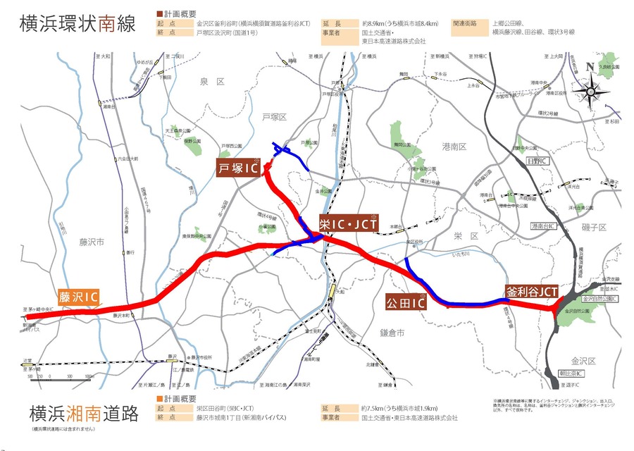
The Yokohama Loop South Line runs from Kamariya Junction on Yokohama Yokosuka Road in Kanazawa Ward to Totsuka Ward National Route 1 (near Fukiage Intersection) through Sakae Ward (partly in Kamakura City).
The Yokohama Shonan Road starts from the Sakae Interchange Junction (tentative name) on the Yokohama Loop South Line, passes through the northern part of Kamakura City with a tunnel structure from near Kojaku-cho, Totsuka-ku, passes underground on National Route 1, and Fujisawa Interchange in Jonan, Fujisawa-shi. Connect to the Shin-Shonan Bypass and National Route 1.
The Yokohama Loop South Line and the Yokohama Shonan Road are positioned as part of the Ken-O Expressway (Metropolitan Metropolitan Chuo Expressway).

outline
| Items | Yokohama Loop South Line | Yokohama Shonan Road |
|---|---|---|
| Name of city planning | 1.3.3 High-speed Yokohama Loop South Line | 1.4.7 Yokohama Shonan Road |
| Starting point to end point | Kamariya-cho, Kanazawa-ku, Yokohama-shi to Kumizawa-cho, Totsuka-ku, Yokohama-shi | Taya-cho, Sakae-ku, Yokohama-shi 1-chome, Jonan, Fujisawa-shi |
Extension | Approximately 8.9km (Yokohama city area: approximately 8.4km; | Approx. 7.5km (Yokohama city area: approximately 1.9km; |
| Doorway | 3 locations (Koda IC, Sakae IC / JCT, Totsuka IC)※ | 2 locations (Sakae IC, JCT*, Fujisawa IC) |
| Road structure | 6 lanes, design speed of 80km/h (Class 1, Class 3) | 4 lanes, design speed of 80km/h (Class 1, Class 3) |
| Business operators | Ministry of Land, Infrastructure, Transport and Tourism, East Nippon Expressway Co., Ltd. | Ministry of Land, Infrastructure, Transport and Tourism, East Nippon Expressway Co., Ltd. |
IC is interchanged, JCT is junction. ※The names of ICs other than Fujisawa ICs and JCTs are tentative names.
・Please refer to the following related links for routes, structures, progress, etc.
Related link
・Yokohama Loop South Line (Yokohama National Highway Office, Ministry of Land, Infrastructure, Transport and Tourism) (outside site)
・Yokohama Kanminami (East Nippon Expressway Co., Ltd. Yokohama Construction Office) (outside site)
・Yokohama Shonan Road (Ministry of Land, Infrastructure, Transport and Tourism Yokohama National Highway Office) (outside site)
・Ken-O Expressway (Kanto Regional Development Bureau, Ministry of Land, Infrastructure, Transport and Tourism) (outside site)
・Related Street Pages (Roads> Construction)
Fujisawa, Yokohama Line
Kamigo Koda Line
Notice
Currently, there is no information to inform you.
Inquiries to this page
Road and Highway Bureau Yokohama Ring Road Coordination Division
Telephone: 045-671-2759
Telephone: 045-671-2759
Fax: 045-651-2325
Email address: do-yokokan@city.yokohama.jp
Page ID: 473-006-575


