


Here's the text.
Kamigo Koda Line
Last Updated November 1, 2024
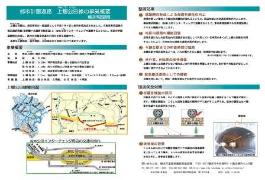
The Kamigo Koda Line was decided in 1995 as a general road in southern Sakae Ward. In addition to connecting the Yokohama Loop South Line (Metropolitan Metropolitan Chuo Expressway) and the Koda Interchange, this route forms an arterial road network in Sakae Ward to facilitate automobile traffic in the city.
The business is divided into three districts: the Kamigo district, the Katsuradai district, and the Koda district.
In addition, we held maintenance plan briefing session in the three districts in 2016.
◆Kamigo district, Katsuradai district maintenance plan briefing session (held on June 26, 27, 2016) document (1/3) (PDF: 13,799KB), document (2/3) (PDF: 19,366KB), document (3/3) (PDF: 14,858KB)
◆Koda district maintenance plan briefing session (held on December 2, 3, 2016) document (1/1) (PDF: 16,973KB)
March 15, 16, and 17, 2019 in the Koda area
We carried out briefing session of "house investigation about high-speed Yokohama ring south line (Koda Kasama tunnel construction) and Kamigo Koda line ((tentative name) Katsuracho tunnel construction)".
◆Documents (house survey briefing materials) (PDF: 7,307KB)
◆Summary of the Meeting: Materials (Summary of the proceedings) (PDF: 131KB)
On March 16 and 22, 2019, in the Koda district
We carried out briefing session of "house investigation about Kamigo Koda Line ((tentative name) Katsuracho tunnel construction)".
◆Documents (house survey briefing materials) (PDF: 6,657KB)
◆Summary of the Meeting: Materials (Summary of the proceedings) (PDF: 122KB)
November 28, 2020 and December 1, 2020
A briefing session on "(tentative name) Katsuracho Tunnel Construction" was held.
◆Materials (PDF: 4,202KB)
◆Summary of the Meeting: Materials (Summary of the proceedings) (PDF: 128KB)
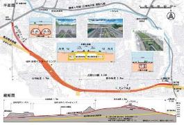
| Section | Kamigo-cho, Sakae-ku (Kobe Bridge Intersection)-Koda-cho, Sakae-ku (Katsuracho Intersection) | ||||
|---|---|---|---|---|---|
| Scale | Approximately 3,200m in length, standard width 17 to 32m (4 lanes, 2 lanes) | ||||
| Business district | Kamigo district: Approx. 200m [Kobe Bridge Intersection - Nishigaya housing complex Entrance Intersection] Katsuradai district: Approx. 1,300m [Nishigaya housing complex Entrance Intersection-Near Katsuradai Daishi Park] Koda district: Approximately 1,700m [Near Katsuradai Daishi Park-Katsuracho Intersection] | ||||
| Maintenance effect | ◆Improvement of traffic convenience through the formation of a road network | ||||
| Construction contract details | ◆Urban planning road Kamigo Koda Line (Koda area) Road construction work | ||||
| Overview |
|
※From 2007, the Construction Department Construction Division has been in charge of the Kamigo Koda Line project.
(In addition, the Koda interchange section is in charge of the Yokohama Ring Road Adjustment Section.)
You may need a separate PDF reader to open a PDF file.
If you do not have it, you can download it free of charge from Adobe.
![]() To download Adobe Acrobat Reader DC
To download Adobe Acrobat Reader DC
Inquiries to this page
Construction Division, Construction Department, Road and Highway Bureau Construction Department
Telephone: 045-671-3521
Telephone: 045-671-3521
Fax: 045-663-8993
Email address: do-kensetsu@city.yokohama.lg.jp
Page ID: 777-760-265


