Here's the text.
Yokohama Ring Road
Last Updated November 27, 2024
What is the Yokohama Ring Road?
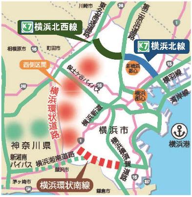
The Yokohama Ring Road “Yokokan” is an automobile-only road that forms the framework of the Yokohama City road network.
The plan is to connect a radius of 10 to 15 km from the city center of Yokohama in a ring, and the Yokohama Loop South Line is currently under business. About west section, we examine while looking at road network plan of metropolitan area or road situation of Motoichi.

| Line name | Start and end point | Extension | Materials |
|---|---|---|---|
| Yokohama Kita Line | Yokohama Porthoku JCT-Namamugi JCT | 8.2 | Yokohama Kita Line opening brochure (H29.3) (PDF: 3,767KB) |
| Yokohama Northwest Line | Yokohama Aoba JCT-Yokohama Kohoku JCT | 7.1 | Yokohama Northwest Line Brochure (R2.3 March) (PDF: 2,833KB) |
| Yokohama Loop South Line | Kamariya JCT to Tozuka (tentative name) | 8.9 | Yokohama Loop South Line (Yokohama National Highway Office, Ministry of Land, Infrastructure, Transport and Tourism) (outside site) |
Role of Yokohama Ring Road, etc.
High-speed Kanagawa No. 7 Yokohama North Line and Yokohama Northwest Line will be connected to the Outer Ring Road via the Tomei Expressway, and the Yokohama Ring South Line will be connected to the Yokohama Shonan Road and other parts of the Tokyo metropolitan area as part of the Ken-O Expressway. By forming a network, access to various parts of the country, such as the Tohoku Expressway, the Kanetsu Expressway, and the Chuo Expressway, will be dramatically improved, and strengthen the international competitiveness of Yokohama Port, and the international container strategic port.
In addition, the improvement of the horizontal ring will secure multiple emergency transportation routes in the event of a disaster, thereby strengthening disaster prevention capabilities.
In addition, the strengthening of the road network is expected to reduce traffic congestion on existing roads, reduce travel time, and improve the environment.
The horizontal ring facilitates the flow of people and goods, supports the development of Yokohama, and greatly contributes to the safety and security of citizens.
Please take a look at the details.
Building permits (underground structures, etc.) based on Article 53 of the City Planning Act of the North Line and Northwest Lines
When building in the area of the city planning road, permission under Article 53 of the City Planning Act is required, but since the north and northwest lines have been maintained, permission has been granted by consulting with the facility manager. Consider it.
A brush with "ground right setting" in the right part (items related to rights other than ownership) such as a certificate of entry (registered copy) is a land with structures (underground facilities) underground. Basically, the landowner is the manager of the structure (underground facility), and the consultation destination is also the landowner.
[Contact for Article 53 of the City Planning Act]
City of Yokohama, Housing and Architecture Bureau City Planning Division
TEL 045-671-3510
[Administrator (= consultation)]
Metropolitan Expressway Co., Ltd. Kanagawa Bureau Road Management Section
TEL 045-307-0516
For details, please refer to the link below.
Building permit based on Article 53 of the City Planning Act
Yokohama Ring Road Leaflet (PDF: 4,869KB)
You may need a separate PDF reader to open a PDF file.
If you do not have it, you can download it free of charge from Adobe.
![]() To download Adobe Acrobat Reader DC
To download Adobe Acrobat Reader DC
Inquiries to this page
Road and Highway Bureau Yokohama Ring Road Coordination Division
Telephone: 045-671-2778
Telephone: 045-671-2778
Fax: 045-651-2325
Email address: do-yokokan@city.yokohama.lg.jp
Page ID: 871-754-306


