


- Yokohama-shi Top Page
- Business
- Menu by field
- Construction and City Planning
- Urban planning
- Restrictions and Certification of City Planning
- Location confirmation of city planning decision line
- Method to identify the location of the survey site [R Mappie]
Here's the text.
Method to identify the location of the survey site [R Mappie]
Last Updated December 13, 2024
What is the location of the survey site?
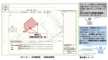
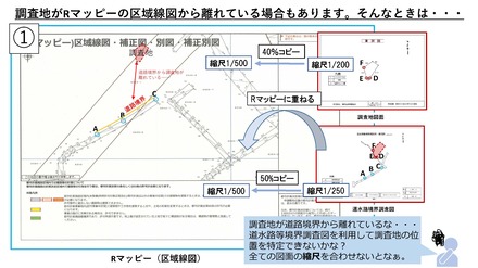
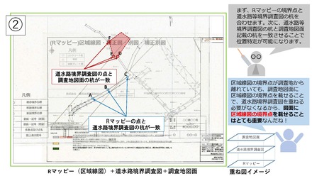
By matching the boundary point (* 1) of R Mapppi with the pile on the survey map surface, and the road boundary of both drawings, the positional relationship between the survey site and the city planning decision line can be confirmed, and it can be used for architectural planning. (* 2). In addition, if the survey site is far from the road boundary, it is possible to identify the location by using the road waterway boundary survey map, official map, layout drawing of the architectural plan summary book (see the list of materials). May be.
Please refer to City Planning Division instruction section about question about identification of position of investigation place.
※1: Boundary point shows positions such as piles that city establishes as road boundary. In the boundary survey map, boundaries are determined by various types of signs such as city piles, city studs, private piles, and points on the map, but piles may not exist in the site.
※2: When submitting the created drawings as attachments to the confirmation and examination organization, please attach them as explanatory materials such as drawings when specifying the location of the survey site. In addition, about city planning facility under business, please refer to City Planning Division by all means whether identification of work position is correct.
Method to identify the location of the city planning decision line at the survey site
Points to note when identifying the location of the survey site
Be sure to check the following before working.
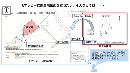
・Unify the scale of all drawings used for work, and make the dimensions around the site overlapped.
・When specifying the location of the survey site, be sure to match it to be a disadvantageous side (PDF: 706KB) for the survey site.
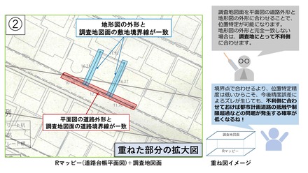
・If two or more boundary points of R Mappie (area map) and one or more road boundary lines do not match, the specific accuracy of the position cannot be secured.
(The more matching points and lines, the higher the accuracy of the position is.)
Method of identifying position in R Mapy (area map)
The boundary point of R Mappie (area map) (PDF: 1,368KB) matches the pile on the survey map surface, and the road boundary of both drawings, and identifies the location of the survey site.
How to identify positions using other materials
If the survey site is far from R Mappie (area map) and the location cannot be specified only with R Mappie (area map), it is necessary to identify the location using other materials.
Materials that can be used to identify the location of the survey site
The materials that can be used to identify the location are as follows.
Please refer to the pdf file for the location identification method using each document.
Please refer to City Planning Division instruction section about question about identification of position of investigation place.
| How to identify position using materials | Drawings to be used | How to get it | HP |
|---|---|---|---|
| Road drawing (PDF: 1,635KB) | Road and waterway boundary survey map |
Road ledger system terminal (City Hall 2F Yokohama Building Information Center or City Hall 22F Road and Highway Bureau Road Investigation Section window) |
Reading of boundary survey maps such as roads and waterways |
Public Works Office window |
List of Public Works Office | ||
| Road location designation map | Yokohama-shi administrative map information provision system (i-mappy) or building summary book reading system terminal |
Yokohama-shi administrative map reporting system (outside site) Certification and browsing related to construction and development |
|
| Narrow road map | Web browsing system such as architectural plan summary documents ※Or browsing system terminal such as building summary book |
||
| Neighboring land drawing (PDF: 1,776KB) | Land area survey map | Yokohama Legal Affaires Bureau, Ministry of Justice | List of office work handling Yokohama Legal Affaires Bureau (real estate registration) (external site) |
| Cadastre Map | Cadastre Map Viewing System Terminal |
Guidance of cadastral survey window | |
| Outline of Architectural Plan | Web browsing system such as architectural plan summary documents ※Or browsing system terminal such as building summary book |
Certification and browsing related to construction and development | |
| Development drawings (PDF: 1,726KB) | Development Register | Viewing system terminal such as building summary documents |
|
| Replacement map | "Kukappu", a resettlement map viewing system |
"Kukappu", a resettlement map viewing system |
※: Various drawings can be obtained using the Web browsing system such as the Yokohama City Outline Book. (If you want to use this system on your own PC, you need to apply for use. It takes about 1-2 days to be available, so if you are in a hurry, please obtain it at [Yokohama Building Information Center on City Hall 2F].
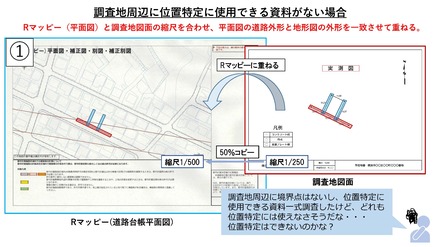
How to identify position in R Mapy (plan view)
The survey map surface matches the road shape of R Mappie (floor plan) (PDF: 1,628KB) with the outer shape of the topographic map, and identifies the position.
※Since the specific accuracy of the position on the floor plan is low, errors are likely to occur. Therefore, it is not recommended to use it in architectural planning.
You may need a separate PDF reader to open a PDF file.
If you do not have it, you can download it free of charge from Adobe.
![]() To download Adobe Acrobat Reader DC
To download Adobe Acrobat Reader DC
Inquiries to this page
Urban Planning Division, Housing and Architecture Bureau Planning Department
Telephone: 045-671-3510
Telephone: 045-671-3510
Fax: 045-550-4913
Email address: kc-tokei-shido@city.yokohama.lg.jp
Page ID: 964-777-611


