


- Yokohama-shi Top Page
- Living and Procedures
- Community Development and Environment
- Transportation
- Traffic safety
- Children's School Road Traffic Safety Measures Project
Here's the text.
Children's School Road Traffic Safety Measures Project
In the Yokohama City Mid-Term Plan and the Yokohama City Traffic Safety Measures Conference, we set "zero traffic accident deaths of children on school roads" as a new goal. Since fiscal 2023, we have been focusing on traffic safety measures for children's school roads in both hardware and software, utilizing big data such as traffic accident data and vehicle speed collected at ETC 2.0.
Last Updated October 11, 2024
Initiatives for Traffic Safety Measures for Children's School Roads
Traffic safety measures utilizing data
Utilize big data such as traffic accident data held by police, and visualize dangerous spots on a map.
Child, Safety and Security Map
In addition to the location and outline of accidents involving elementary and junior high school students in the city, anti-crime program information such as suspicious individual information can also be found on Google Maps (My Map function). Please refer to the operation demo video for the functions and operation methods of the map.

Image of child, safety and security map

Children and Safety and Security Map 2D Code

Operation demo video 2D code
Child, safety and security map (outside site)
Characteristics of the map
- You can check the location of traffic accidents for elementary and junior high school students and the outline of the accident.
- Click the icon on the map to display an overview of the traffic accident.
- For voice and suspicious individual information, you can check the summary of outbreaks over the past year by street name.
- Created based on traffic accident data from Kanagawa Prefectural Police (five years from 2019 to 2023).
- Created based on Pigal-kun Children's Safety Email (2023) distributed by Kanagawa Prefectural Police. If you would like to receive Pegal-kun Children's Safety Email, please register from the Kanagawa Prefectural Police website.
Usage
- It is divided into two categories: "elementary school-related accidents" and "junior high school-related accidents".
- The order of display of "Participation type" in the outline of the traffic accident is not the order of negligence weight (first party / second party).
- By default, only traffic accident information is displayed.
- It can be displayed by selecting "anti-crime program Information", "Elementary School / Junior High School School Area", "District Border", etc.
- anti-crime program Information colors areas where more than onesuspicious individual information is available.
- In the order in which "calling out" and "suspicious individual" information is displayed, the date and time of occurrence is changed.
- The operation method of the map depends on your device and OS.
Operation demo video
Child and Traffic Accident Data Map
You can check the location of personal traffic accidents and the outline of accidents involving elementary and junior high school students in the city on Google Maps (My Map Function).
Please use the link below and 2D code.
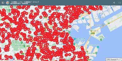 Child and traffic accident data map image
 2D code
Child, traffic accident data map (2019-2023) (outside site)
Characteristics of the map
- You can check the location of traffic accidents and the outline of accidents for elementary and junior high school students throughout the city on Google Maps (My Map Function).
- Click the icon on the map to display an overview of the traffic accident.
- You can also see the traffic accident points on Google Street View.
- Created based on traffic accident data provided by the Kanagawa Prefectural Police (five years from 2019 to 2023).
Usage
- It is divided into two categories: "elementary school-related accidents" and "junior high school-related accidents".
- You can switch between display and hidden by year and category.
- The order of display of "Participation type" in the outline of the traffic accident is not the order of negligence weight (first party / second party).
- The operation method of the map depends on your device and OS.
Overview of traffic safety measures that link software measures and hardware measures
Click here for an overview of the initiatives (PDF: 1,205KB)
Software measures
Initiatives in the All Municipal Elementary Schools School Area
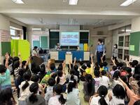
- Traffic safety classes at elementary schools (Hamako Traffic Safety Class)
- Watching activities with the cooperation of parents and local communities
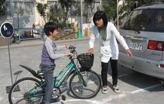
- Visiting guidance for infant traffic safety education
- Traffic safety classes for infant parents
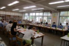
School zone countermeasures council
Traffic safety classes
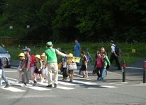
Watching activities (Hatafuri)
Efforts at Schools
At schools, we will use traffic accident data to make efforts according to the situation of each school.
- Local safety guidance through opportunities such as when going to and from school, exploring towns, and excursions to all schools.
- Examination of school routes
- Utilization in comprehensive study time, etc.
Initiatives in the school commuting area for traffic safety promotion schools
[New]
- Traffic safety classes utilizing after-school hours
[Expansion]
- Traffic safety classes at elementary schools (Hamako Traffic Safety Class)
- Visiting guidance for infant traffic safety education
- Traffic safety classes for infant parents
[Enhancement]
- Support for watching activities
Traffic safety classes utilizing after-school hours

Visiting guidance for infant traffic safety education

Traffic safety classes for infant parents
Hardware Measures
Initiatives in the All Municipal Elementary Schools School Area
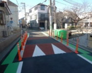
- Road markings, lane markings, reliable color belts, intersection color pavement, etc.
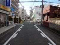
Installation of lane markings
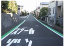
Reliable color belt
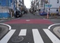
Intersection color pavement
Initiatives in the school commuting area for traffic safety promotion schools
In addition to the above efforts, we consider physical devices (hamp, narrow, zone 30 plus, etc.)
Hump
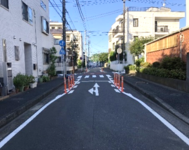
Narrow
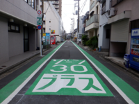
Zone 30 Plus
| Ward | Elementary school name | |
|---|---|---|
| 1 | Minami Ward | Ooka Elementary School |
| 2 | Hodogaya Ward | Fujitsuka Elementary School |
| 3 | Kanazawa Ward | Hakkei Elementary School |
| 4 | Aoba Ward | Fujigaoka Elementary School |
| 5 | Izumi Ward | Ryokuen Gakuen |
| Ward | Elementary school name | |
|---|---|---|
| 1 | Naka Ward | Tateno Elementary School |
| 2 | Konan Ward | Nagano Elementary School |
| 3 | Tsuzuki Ward | Tsuda Nishi Elementary School |
| 4 | Seya Ward | Hara Elementary School |
Business Background
In addition to Otsu City, Shiga Prefecture (May 2019) and Yachimata City, Chiba Prefecture (June 2021), there have also been painful accidents involving the sacrifice of children, and traffic safety measures for children have become a social problem.
Based on this situation, Yokohama City has set a new goal for traffic safety at the Yokohama City Traffic Safety Measures Council from 2023 to zero traffic accident deaths from children on school roads.
Mayor's message at the Yokohama City Traffic Safety Measures Conference (October 18, 2022)
[Reference] Results of Preliminary Implementation Areas
You may need a separate PDF reader to open a PDF file.
If you do not have it, you can download it free of charge from Adobe.
![]() To download Adobe Acrobat Reader DC
To download Adobe Acrobat Reader DC
Inquiries to this page
Road Policy Promotion Section, Road and Highway Bureau Road Policy Promotion Department
Telephone: 045-671-2323
Telephone: 045-671-2323
Fax: 045-550-4892
Email address: do-seisaku@city.yokohama.jp
Page ID: 239-525-311


