


Here's the text.
Block reference points, etc.
Last Updated April 5, 2024
Land Registry and Survey Division manages and browses block reference points and basic survey reference points (basic survey reference points for public-private boundaries in urban areas).
- What is a block reference point?
- What is the basic survey reference point (basic survey reference point for public-private boundary in urban areas)
- Handling of survey results associated with the Tohoku-Pacific Ocean Earthquake
- Points subject to management
What is a block reference point?
The block reference point is a survey reference point (geographical results 2000) developed by the Ministry of Land, Infrastructure, Transport and Tourism as part of the “Basic Survey on Urban Renewal Blocks”. It is installed in the area.
From April 1, 2008, the management authority of the block reference point installed in Yokohama City has been transferred from the Ministry of Land, Infrastructure, Transport and Tourism to Motoichi.
What is the basic survey reference point (basic survey reference point for public-private boundary in urban areas)
The basic survey reference point is a survey reference point (geographical results 2011) developed by the Ministry of Land, Infrastructure, Transport and Tourism as the basis of cadastral surveys, and is installed in the Kamariya district of Kanazawa-ku.
※The Yokohama City Public Control Point (Research Results 2011) is managed by Road and Highway Bureau. Specifically, please see "page of road investigation section".
Handling of survey results associated with the Tohoku-Pacific Ocean Earthquake
The block reference point in Yokohama City is the result of the geodetic results 2000 at the time of installation, and will not be revised to the results after the earthquake for the time being.
Inspection is performed as before, but we have not approved the use of the survey results.
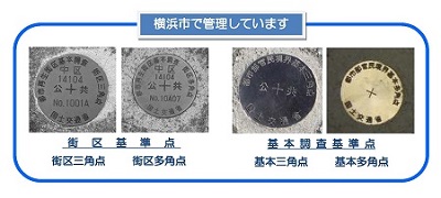
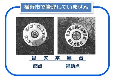
Points subject to management
Land Registry and Survey Division manages block reference points established by the Ministry of Land, Infrastructure, Transport and Tourism (MLIT) and block polygon points. About "nodes" and "assistance point", it is not targeted for management because it is temporary point, and it is closed on the same day as transfer to Motoichi.
Of the basic survey reference points, "basic triangular points" and "basic polygon points" are also subject to management.
About reading
The results of the block reference point and the basic survey reference point can be viewed at the Land Registry and Survey Division Office of the Green Environment Bureau.
For more information, please refer to the Land Registry and Survey Division Office Guide.
Management conservation
Most of the block reference points and basic survey reference points are installed on roads, so they may be affected by road excavation work. Therefore, we have established the conservation Guidelines for Management of Regional Control Points in Yokohama City, which describes procedures related to the general handling and management of block control points in conservation, etc.
About removal of block reference point
A notification of removal is required in advance.
Construction enforcer
In cases other than construction under the jurisdiction of Yokohama City
Block reference point removal approval application (No. 3 style)
In the case of construction under the jurisdiction of Yokohama City
Block reference point removal consultation (No. 5 style)
Land owners, etc.
Block reference point removal bill (No. 7 style)
Transfer of basic survey reference points, etc.
Measures related to the request for the relocation of the survey mark of the basic survey reference point stipulated in Article 30 of the National Land Survey Act are stipulated in the "Business Administration Guidelines for Transfer of the Basic Survey Reference Point of Cadastre".
Basic Survey Reference Point Transfer Invoice (No. 8 Style)
You may need a separate PDF reader to open a PDF file.
If you do not have it, you can download it free of charge from Adobe.
![]() To download Adobe Acrobat Reader DC
To download Adobe Acrobat Reader DC
Inquiries to this page
General Affairs Department Land Registry and Survey Division, Green Environment Bureau
Telephone: 045-671-2619
Telephone: 045-671-2619
Fax: 045-662-3630
Email address: mk-chisekichosa@city.yokohama.lg.jp
Page ID: 631-688-508


