


- Yokohama-shi Top Page
- Aoba Ward Top Page
- Health, Medical and Welfare
- Health and Medical Care
- Health promotion
- Introduction of Walking Course
Here's the text.
Introduction of Walking Course
Last Updated September 9, 2024

"I want to stay healthy and healthy forever!" That's what everyone wants.
To do so, you need to protect your own health from a young age.
Walking is an exercise that everyone can easily start and is effective for health promotion.
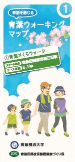
A "Aoba Walking Map to Feel the Season" created with Toin University of Yokohama is being distributed at the ward office.
As part of the health promotion promotion project with Toin University of Yokohama, we have created three copies of Aoba Walking Maps.
Why don't you enjoy the seasonal Aoba Ward through walking?
Course name (click to open the PDF file) |
Route | Distance | |
|---|---|---|---|
| Aoba Sakura Walk (PDF: 6,607KB) | Eda Station-Sakura-dori St.-Oba Kayanoki Park-Toin Gakuen | 5.1km | |
| A Aoba Rose Walk / B Mizusawa Forest, Hirase River Headwaters, Hanamono Hill Tour (PDF: 11,255KB) | A Tama Plaza Station-Sugao Ryokuchi-Hoki Park-Ekoda Taiyo Park |
A6.4km |
|
| Teraya Oldness and Walk (PDF: 7,332KB) | Toin University of Yokohama, along Tsurumi River-Teraya-Kamoshida Park | 4.8km |
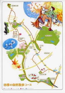
Illustration maps (17 courses) are being distributed at the ward office.
Member of health activity promotion receives commission from the mayor and works to promote health promotion of inhabitants of a ward in area. We have created a walking course that can be enjoyed so that it can be used for the health promotion of local residents.
This time, the course selected by the health activity promotion staff was actually walked with the students of Yokohama University of Art and the health activity promotion staff, and the illustration map "Let's walk every day!" "Walking Aoba" was created. The highlights of each course are introduced with illustrations and photos. Let's go for walking with this map with local people and family.
Course name (click to open the PDF file) |
Route | Distance | |
|---|---|---|---|
| 1 | Course that walks along the river and tree-lined roads while feeling the season (PDF: 21,200KB) |
public hall Aoba → Mitakedai Park → Fujigaoka Station | 3.8㎞ |
| 2 | Teraya / Kamoshida Satoyama Tour (PDF: 1,292KB) | [Cirrelation] |
4.0㎞ |
| 3 | Ichigao Station → Ichigao Archaeological Park → Tofuku-ji Temple | 4.5㎞ | |
| 4 | [Cirrelation] |
3.0㎞ | |
| 5 | The murmuring walk to feel the flowers of the four seasons (PDF: 14,216KB) Relaxing on the promenade of Tsurumi River~ |
Fujigaoka Ekimae Park → The path of the babbling Tanimoto → The temple family and the four seasons house | 5.7㎞ |
| 6 | Nature full Naruse ridge green road course (PDF: 14,128KB) | [Cirrelation] Kodomonokuni Station → Narusedai ridge road → Tokuonji Temple |
5.2㎞ |
| 7 | Course around rural scenery of Ondacho and paths of hills (PDF: 1,923KB) |
Sakuradai Park → Sumiyoshidai Daisan Park | 3.8㎞ |
| 8 | Walk along the road of Yokohama City Boundary (PDF: 1,631KB) | [Cirrelation] Narayama Park → Midoriyama → Tamagawa University |
6.6㎞ |
| 9 | Let's walk! Nara Kita housing complex 1 lap course (PDF: 1,182KB) | [Cirrelation] In front of Yokohama Nara Post Office → Nara Kita housing complex |
1.4㎞ |
10 |
Satoyama course from Ekoda to Hoki (PDF: 878KB) | Ekoda Park → Hoki Park |
3.3㎞ |
| 11 | Spring, discover! Departing from Tama Plaza South Exit! Course (PDF: 17,083KB) | [Cirrelation] Tama-Plaza Station → Kokugakuin University |
3.8㎞ |
| 12 | Promenade course full of nature (PDF: 15,216KB) | [Cirrelation] Kataraijuku Park → Centerkita |
5.4㎞ |
| 13 | Promenade course to enjoy trees (PDF: 1,010KB) | Izumi Park → Tsuzuki Chuo Park |
4.4㎞ |
| 14 | Nature walk course of four seasons (PDF: 1,115KB) | [Cirrelation] Eda Daishi Park → Kuzugaya Park |
6.9㎞ |
| 15 | Promenade course to enjoy the nature of the four seasons (PDF: 28,604KB) | [Cirrelation] Kenzan Park → Hoki Park |
5.1㎞ |
| 16 | Utsukushigaoka Park 1 lap course (PDF: 1,980KB) | Around Utsukushigaoka Park |
0.6㎞ |
| 17 | Inari-mae Kofun, Iron and Kurosuda Natural Road Tour Course (PDF: 8,897KB) |
Aoba Ward Office → Susukino Park | 6.1㎞ |
Other walking map
Course name (click to open the PDF file) | Route | Distance | |
|---|---|---|---|
| Utsukushigaoka Health Promotion Pedestrian Network (Beginner) (PDF: 1,710KB) | [Cirrelation] | 1.2㎞ | |
Utsukushigaoka Health Promotion Pedestrian Network (Intermediate) (PDF: 1,710KB) | [Cirrelation] | 4.2㎞ | |
Utsukushigaoka Health Promotion Pedestrian Network (Advanced) (PDF: 1,710KB) | [Cirrelation] | 6.4㎞ | |
From Tana Station to Onda Station | 10.5㎞ | ||
[Cirrelation] | 1.8㎞ | ||
| Children's Country-Around Jikecho | 6.6㎞ | ||
Teraya oldness and village course to feel nature and enjoy art (PDF: 5,863KB) | [Cirrelation] | 2.6㎞ | |
Teraya Hometown Village Greenery and Art Village Aruki Course (PDF: 552KB) | Teraya Hometown Village Shiki no Ie-bus stop "Jikecho" | 2.3㎞ | |
| Ichigao Station-Ichigao Yokoana Burial Mounds | 2.7㎞ | ||
Let's find early blooming cherry blossoms and early spring flowers (PDF: 2,184KB) | Around Eda Station to Ichigao Station | 6.0㎞ | |
Cherry Blossom Cherry Blossom Cherry Blossom Viewing Course (PDF: 3,521KB) | Around Tamapuraza Station to Susukino Station | 5.0㎞ |
Introduction of 45 courses in the city in a list About the end of publication of "Aoba walking course map"
About map which introduced 45 courses in ward, we finished publication for convenience of maintenance.
You may need a separate PDF reader to open a PDF file.
If you do not have it, you can download it free of charge from Adobe.
![]() To download Adobe Acrobat Reader DC
To download Adobe Acrobat Reader DC
Page ID: 864-464-028


