


現在位置
- Yokohama-shi Top Page
- Living and Procedures
- Community Development and Environment
- Urban Development
- District planning, building agreements, etc.
- District planning
- District planning for each ward
- Seya Ward
- K-003: Seya Akuwa Miyakoshi district residential area advanced use district
Last Updated December 9, 2022
Here's the text.
K-003: Seya Akuwa Miyakoshi district residential area advanced use district
City planning decision: December 24, 1993 / City planning change: January 14, 1998
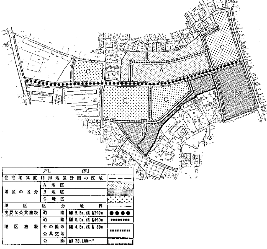
Plan drawing (division of district, placement of major public facilities, district facilities)
| Name | Seya Akuwa Miyakoshi district residential area advanced use district plan | ||
|---|---|---|---|
| Position | Akuwa-cho, Seya-ku, Yokohama-shi and Akuwa-Higashi 4-chome ground | ||
| Area | About 4.2ha | ||
| Ward Areas No 1. Bill ・ Opening Departure Ma'am Ha Hoping All No Sir Needle |
Targets of residential area advanced use district planning | This area is a district that contains collective farmland left in low-rise residential urban areas, and is expected to cause sprawling by mini-development if left untouched. In the district, the west side is high on the border of the Akuwa River, the east side has a low undulating terrain, and has an environment blessed with forest areas on the slopes. This residential area advanced use district plan forms a good residential area including middle- and high-rise houses by promoting the advanced use of land while maintaining harmony with the surrounding urban area along with the maintenance of necessary public facilities. The goal is to maintain the environment. |
|
| Basic Policy on Land Use | Divide three districts and guide land use according to their respective policies. 1 Area A |
||
| Policy for the development of urban infrastructure | In order to improve the convenience of the surrounding area and to ensure the safety and convenience of traffic as a middle- and high-rise residential area, a new arterial road in the district will be newly established in the center of the district and the appropriate placement of divided roads will be planned. About park, we install one block park including natural forest at the southern end of district. |
||
| Policy for maintenance of buildings, etc. | In order to guide a good living environment according to the characteristics of each district, restrictions on the use of the building, the maximum ratio of the total area of the building to the site area, the minimum floor area of the building, the position of the wall Defines restrictions, the maximum height of buildings, restrictions on forms or designs such as buildings, and restrictions on the structure of fences or fences. In addition to securing necessary parking lots and bicycle parking lots, we will guide buildings that take into account the use of elderly people. |
||
| Greening Policy | We plan active greening such as site of building or park to form good environment. | ||
| Placement and scale of major public facilities | Roads | Width: 9.5m, length: 390m | |
| k-003 Residential Area Advanced Utilization Area Development Plan | |||||
|---|---|---|---|---|---|
| Placement and scale of district facilities | Roads | Width 6.0m | Approximately 460m in length | ||
| Other public open space | Width 4.5m | Approximately 30m in length | |||
| Park | Approximately 3,100㎡ | ||||
| Construction Construction Goods Etc. Ni Seki S L A matter Section |
Classification of district | Name | District A | District B | District C |
| Area | About 1.2ha | About 1.2ha | Approx. 1.8ha | ||
| Restrictions on the use of buildings | Buildings other than the buildings listed in the following items must not be built. 1 Housing |
Buildings listed in the following items shall not be constructed. 1 Shrines, temples, churches and the like |
|||
| Maximum ratio of total building area to site area | ―― | ―― | 15/10 | ||
| Minimum site area of buildings | The area shall be more than 150m2 and the number of dwelling units multiplied by 75m2. | The area shall be more than 150m2 and the number of dwelling units multiplied by 50m2. | The area shall be more than 200m2 and the number of dwelling units multiplied by 40m2. | ||
| Provided, however, that this shall not apply to land that falls under any of the following. 1 Used as a site for public toilets, police station offices, and similar buildings necessary for the public interest |
|||||
| Restrictions on the position of the wall | The distance from the outer wall of the building or the surface of the pillar in place of this to the boundary of the front road shall be 1.0 m or more, and the distance to the adjacent land boundary shall be 0.6 m or more. | The distance from the outer wall of the building or the surface of the pillar in place of this to the boundary of the front road and the boundary of other public vacant lots shall be 2.0 m or more, and the distance to the adjacent land boundary shall be 1.0 m or more. | |||
| Provided, however, that this shall not apply if the building or the part of the building at a distance less than the limit of this distance falls under any of the following. 1 The total length of the center line of the outer wall or pillar in place of it is 3m or less |
|||||
| Maximum height of buildings, etc. | ―― | ―― | 1 The height of the building must not exceed 15m. (2) The height of each part of the building shall be less than the one obtained by multiplying the horizontal distance in the true north direction from each part to the front road or the center line of other public vacant lots by 0.6 and adding 5m. Must. |
||
| Restrictions on forms or designs of buildings, etc. | 1 The roof and outer wall of the building shall not use stimulating colors or decorations. Designs such as 2 buildings and outdoor advertising materials shall be considered in consideration of the surrounding environment. |
||||
| Restrictions on the structure of a fence or fence | The structure of the fence or fence facing the road shall have hedges, fences and similar openness. However, this excludes gateposts and similar items. | ||||
Inquiries to this page
Urban Development Bureau Regional Town Development Department Regional Town Development Division
Telephone: 045-671-2667
Telephone: 045-671-2667
Fax: 045-663-8641
Email address: tb-chiikimachika@city.yokohama.lg.jp
Page ID: 537-957-432


