


- Yokohama-shi Top Page
- Living and Procedures
- Community Development and Environment
- Rivers and sewers
- Sewer
- Connection to the sewer
- Rainwater infiltration
- Utilization of infiltration facility setting judgment map
Here's the text.
Utilization of infiltration facility setting judgment map
Last Updated May 13, 2024
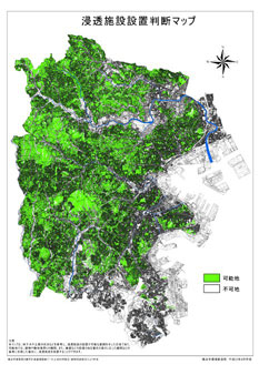
The "Infiltration Facility Installation Judgment Map" shows whether the area can set up an infiltration facility based on topography, soil quality, and groundwater level judgment factors.
Rainwater infiltration facilities can be installed when it is determined as "possible land" in the "infiltration facility setting judgment map", but cannot be installed if sufficient separation from buildings or retaining walls cannot be secured.
- Confirm the installation judgment of the area ("possible land", "impossible land") using the "infiltration facility setting judgment map".
- For each installation judgment at the installation location, the following field surveys are conducted to determine whether or not the installation is final.
A. possible land
- a.Check the separation between the building and the outside of the crushed stone.
- b.Check the separation between the adjacent boundary, retaining wall, etc. and the outside of the crushed stone.
- c.If there is a slope or retaining wall at the adjacent boundary, check the separation according to the height.
About separation from buildings of rainwater penetration masu (PDF: 136KB)
B. Unexpected land
It is a district where rainwater infiltration facilities are restricted, or a district where even if rainwater infiltration masu is installed, the function is not fully exhibited.
Commentary
The judgment factors in the "Infiltration Facility Installation Judgment Map" are as follows.
Areas that are not suitable for installation based on the situation of each element have been designated as "impossible land", and other areas have been designated as "possible land".
Infiltration facility setting judgment map (PDF: 8,493KB) [April 2011 version]
A topography
Do you fall under the danger zone of steep slopes? → No installation: Dangerous areas of steep slope collapse
B. soil quality
Is it hard to penetrate? → Not suitable for penetration: Kazusa Group (solidated silt)
A. Underground water level
Can the penetration capacity of the infiltration facility be demonstrated? → Not suitable for penetration: The groundwater level is less than 2m from the ground.
You may need a separate PDF reader to open a PDF file.
If you do not have it, you can download it free of charge from Adobe.
![]() To download Adobe Acrobat Reader DC
To download Adobe Acrobat Reader DC
Inquiries to this page
Sewerage River Bureau Management Promotion Department Management Promotion Section (plan)
Telephone: 045-671-2838
Telephone: 045-671-2838
Fax: 045-664-0571
Email address: gk-management@city.yokohama.lg.jp
Page ID: 441-540-579


