


- Yokohama-shi Top Page
- Living and Procedures
- Community Development and Environment
- Roads
- Planning and planning
- Examination of appropriate bridge intervals in the Nakashita basin of Tsurumi River
Here's the text.
Examination of appropriate bridge intervals in the Nakashita basin of Tsurumi River
Last Updated September 30, 2024
We will inform you about the results of the questionnaire regarding the construction of bridges [FY2024]
In fiscal 2015, City of Yokohama, Road and Highway Bureau has been examining the appropriate distance between bridges in the Nakashita basin of the Tsurumi River (Kohoku Ward and Tsurumi Ward), and has arranged the new bridge between Shin-Yokohama Ohashi and Niihabashi in Kohoku Ward.
We conducted a questionnaire to listen to the opinions of local residents. I would like to inform you that the results have been finalized.
■Overview of the questionnaire
•Major Subjects: Those who live in the Niiwa and Okurayama districts of Kohoku-ku
•Survey method: Electronic application system, mail, etc. (known through the Neighborhood Associations circulation board)
•Implementation period: March 26-April 26, 2014
•Number of responses: 363 (111 people in Niiba area, 246 people in Okurayama area, 6 others)
■Aggregation method
•In the question "Housing" of the questionnaire, the total was roughly divided into 1 Niiba district and 2 Okurayama district.
•Since the number of responses in each district is different, the graph of the results is displayed as a percentage.
•Six responses living outside the 2 districts are not included in the total results that are roughly classified in the Niiba and Okurayama districts.
We report examination result about appropriate bridge interval of Tsurumi River Nakashita basin [2015]
In the Nakashita basin of the Tsurumi River (Tsurumi Ward and Kohoku Ward), there are many areas where bridge intervals are wide, and issues remain in terms of local traffic processing, integration of both banks, and regional disaster prevention. Therefore, in 2015, we examined the necessity of new bridge construction from three viewpoints: [traffic], [town development], and [disaster prevention].
As a result of the study, we selected the section between Shintsurumi Bridge and Sueyoshi Bridge in Tsurumi Ward and Shin-Yokohama Bridge in Kohoku Ward as sections where it is highly necessary to secure traffic for cars and pedestrians.
From FY2016 (2016), we have been examining the position of bridges and bridge forms specifically.
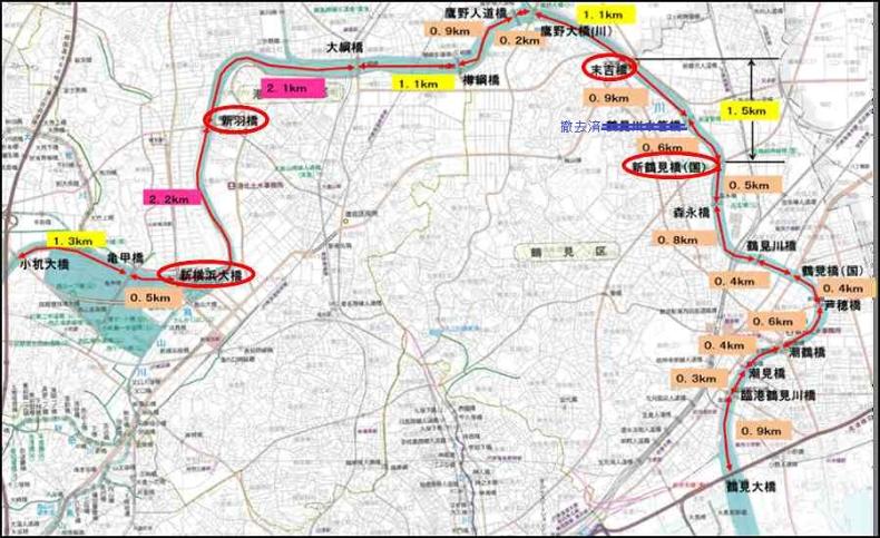
[Bridge location map of the Nakashita basin of Tsurumi River]
You may need a separate PDF reader to open a PDF file.
If you do not have it, you can download it free of charge from Adobe.
![]() To download Adobe Acrobat Reader DC
To download Adobe Acrobat Reader DC
Inquiries to this page
Road and Highway Bureau Planning and Coordination Department Business Promotion Division
Telephone: 045-671-3533
Telephone: 045-671-3533
Fax: 045-651-6527
Email address: do-suishin@city.yokohama.lg.jp
Page ID: 757-772-906


