


Here's the text.
Rmappy
Last Updated December 13, 2024
What is R Mapy?
This is a browsing system that combines a road ledger with an accuracy of about 1/500 scale (map information level 500) and a city planning decision line.
It is possible to check the positional relationship between the boundary point (*) and the city planning decision line yourself.
The data of the city planning decision line posted on R Mappie can be handed over by application for use.
The data format is "shape file" or "geo-database".
Please refer to this website for a list of routes posted on R Mapy.
※: Boundary point shows positions such as piles that city establishes as road boundary. In the boundary survey map, boundaries are determined by various types of signs such as city piles, city studs, private piles, and points on the map, but piles may not exist in the site.
Differences from i-mappy and C-mappy
[i-Mappy] You can check all city planning information.
[C Mappie] You can check the positional relationship between the city planning decision line and the survey site according to the site shape.
[R Mappie] You can check the positional relationship between the city planning decision line and the survey site by the boundary point.
When using R Mappie (C Mappie), be sure to check i Mappie.
Please refer to this page for more details. (External site)
Type of R Mapy
Road ledger area map + city planning decision line
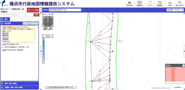
Recommended for those who are conducting the following surveys.
・Those who want to check the positional relationship between the boundary point and the city planning decision line
・Those who want to know the exact location of the city planning decision line on the survey site
Click here for information on how to identify the location of the survey site using R Mappie [R Mappie].
Road ledger floor plan + city planning decision line

R Mappie (Road Ledger Floor Plan + City Planning Decision Line)
Recommended for those who are conducting the following surveys.
・Those who have difficulty in identifying the location even if using R Mappie (road ledger area map) and other materials
・Those who want to confirm whether the city planning decision line conflicts with the survey site
Inquiries to this page
Urban Planning Division, Housing and Architecture Bureau Planning Department
Telephone: 045-671-3510
Telephone: 045-671-3510
Fax: 045-550-4913
Email address: kc-tokei-shido@city.yokohama.lg.jp
Page ID: 998-477-519


