


Here's the text.
Earthquake map
Last Updated September 14, 2021
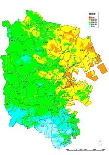
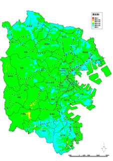
The "Yokohama Earthquake Damage Estimation Survey Report" released in October 2012 shows the distribution of seismic intensity for the three earthquakes targeted for damage estimation.
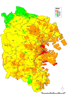
Nankai Trough Giant Earthquake
Yokohama City provides free seismic diagnosis of houses and subsidies for seismic retrofitting work so that wooden houses do not collapse in the event of a major earthquake. Click here for information on free seismic diagnosis and subsidies for earthquake-resistant construction.
・Information on the dispatch system for wooden house seismic diagnosis specialists (Housing and Architecture Bureau website)
・Information on "Yokohama Wooden House Seismic Retrofit Improvement Promotion Project" (Housing and Architecture Bureau website)
Related link
- National Earthquake motion prediction map (Earthquake Research Promotion Headquarters) (outside site)
- Damage Estimation in the country (Cabinet Office Disaster Prevention Information Page) (outside site)
- Kanagawa e-Kana Map "Disaster Prevention and Safety" "Earthquake Damage Estimation Survey Results" (outside site)
- Yokohama-shi administrative map reporting system "Wai Wai disaster prevention map" (outside site)
- Yokohama City Earthquake Damage Estimation Survey Report
- Liquefaction map
Inquiries to this page
Regional Disaster Prevention Section, General Affairs Bureau Crisis Management Department
Telephone: 045-671-3456
Telephone: 045-671-3456
Fax: 045-641-1677
Email address: so-chiikibousai@city.yokohama.jp
Page ID: 890-185-288


