


- Yokohama-shi Top Page
- Disaster prevention and emergency services
- Disaster Prevention and Disasters
- Map of disaster prevention
- Earthquake map
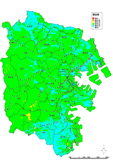
- Nankai Trough Giant Earthquake Earthquake Map
Here's the text.
Nankai Trough Giant Earthquake Earthquake Map
Last Updated July 31, 2024
Earthquake map (each ward version)
Tsurumi Ward (PDF: 2,299KB)
Kanagawa Ward (PDF: 4,390KB)
Nishi Ward (PDF: 1,621KB)
Naka Ward (PDF: 2,730KB)
Minami Ward (PDF: 2,583KB)
Konan Ward (PDF: 3,820KB)
Hodogaya Ward (PDF: 5,335KB)
Asahi Ward (PDF: 6,078KB)
Isogo Ward (PDF: 4,357KB)
Kanazawa Ward (PDF: 3,521KB)
Kohoku Ward (PDF: 4,731KB)
Midori Ward (PDF: 5,833KB)
Aoba Ward (PDF: 4,461KB)
Tsuzuki Ward (PDF: 5,262KB)
Totsuka Ward (PDF: 6,870KB)
Sakae Ward (PDF: 4,361KB)
Izumi Ward (PDF: 3,586KB)
Seya Ward (PDF: 2,945KB)
You may need a separate PDF reader to open a PDF file.
If you do not have it, you can download it free of charge from Adobe.
![]() To download Adobe Acrobat Reader DC
To download Adobe Acrobat Reader DC
Inquiries to this page
Regional Disaster Prevention Section, General Affairs Bureau Crisis Management Department
Telephone: 045-671-3456
Telephone: 045-671-3456
Fax: 045-641-1677
Email address: so-chiikibousai@city.yokohama.lg.jp
Page ID: 914-870-454


