Here's the text.
Rivers in the ward
Last Updated December 12, 2024
Rivers in Totsuka Ward

First-class rivers are rivers managed by the Minister of Land, Infrastructure, Transport and Tourism in principle, and the Sagami River and Tsurumi River are first-class rivers in Kanagawa Prefecture.
The Sakaigawa, Kashio River, Izumi River, Udagawa River, Akuwa River, Na Segawa River, Hirato Nagatani River and Maioka River are second-class rivers in Totsuka Ward. The Izumi River, Udagawa River, Akuwa River, Na Segawa River, Hirato Nagatani River and Maioka River are managed by the The Mayor of Yokohama, while the Sakaigawa River and Kashio River are managed by the Governor of Kanagawa Prefecture.
Ordinary rivers are general names of those that are not rivers under the River Law, and are called general rivers and waterways.
Totsuka Ward includes the Kawakami River, Omen River, Tando River, Sekiya River and Takinogawa River.
| Name of River | Type of river | Contents |
|---|---|---|
| Sakaigawa | Second-class rivers | The Sakai River begins near Lake Shiroyama, Tsukui-gun, and flows north-south through five cities, Machida, Sagamihara, Yamato, Yokohama, and Fujisawa, Tokyo, and flows into Sagami Bay. The water of the river flowing through Totsuka Ward flows into this Sakaigawa river. It is said that the name originated from the country of Sagami (Saga Mi) and the country of Musashi (Musashi) in the past. In the past, the lower reaches of the Sakaigawa River often caused floods as rampage rivers, but at the end of the Meiji era, arable land was reorganized, river improvement, and dam construction were carried out, and it became a smooth river like the present. Was. In addition, due to the construction of a weir, the water of the Sakaigawa main stream was also used as agricultural water. From these remnants, there is a spacious countryside along the Sakaigawa River in Higashimatanocho. The Sakai River begins near Lake Shiroyama, Tsukui-gun, and flows north-south through five cities, Machida, Sagamihara, Yamato, Yokohama, and Fujisawa, Tokyo, and flows into Sagami Bay. The water of the river flowing through Totsuka Ward flows into this Sakaigawa river. |
| Kashio River | Second-class rivers | The Kashio River is a second-class river with a length of about 11 km from the confluence of the Akuwa River and Hirato Nagatani River in Kashiwao-cho, Totsuka-ku to join the Sakaigawa main stream in Kawana, Fujisawa City. The basin area is about 84 km3, the second largest in Yokohama city. It is a typical urban river with advanced urbanization in the basin. The embankment has a promenade under a row of cherry blossom trees. In addition, there is a passage along the waterside where flowers are thriving, so you can enjoy a walk while feeling the flow of water up close. The Kashio River continues for about 4 km straight in the city, but the expression of the waterside is slightly different in some places. |
| Izumi River | Second-class rivers | It is a river that runs north-south through Izumi Ward from Seya Ward and joins the Sakai River in Totsuka Ward. |
| Udagawa | Second-class rivers | Nakata-cho, Izumi-ku begins, flows almost southwest, flows into the Sakaigawa River in Matanocho. Udagawa used to be called the Muraoka River in the past, but in the Taisho era, Mr. Uda built a dike to prevent the river from overflowing, so he came to call it Udagawa. A promenade with a row of cherry blossom trees is set up downstream near the confluence with Sakaigawa. In the middle part, there is a fuchi (citizen's forest) where the legend of the woodman remains, and it is a place to relax. The river downstream from Nakada Bridge at Minami Nakata 5-chome is a river, and the upstream is a normal river (waterway). |
| Akuwa River | Second-class rivers | A river separated from the Kashio River, a tributary of the Sakaigawa River. |
| Name Segawa | Second-class rivers | As the name implies, Na Segawa is a river that flows through Nasecho, and is a second-class river with a length of about 2 km from the golf course in the northern part of Nasecho (Tozuka Country Club) to joining the Akuwa River. It is a river that forms the middle axis of Naze, where the traditional natural scenery of Tando remains strong. In the upper reaches, Nasecho Ogawa Amenity is maintained, and you can walk along the babbling. |
| Nagata Hirato Tanikawa | Second-class rivers | Beginning near Noba-cho, Konan-ku, it flows almost alongside the road called Loop Route 2, and flows into the Kashio River together with the Akuwa River at the border of Kamiyabecho, Nasecho and Kashiocho. In Totsuka Ward, it is a river with little greenery because it flows through the city. |
| Maioka River | Second-class rivers | The Maioka River, which originates from Maioka Park, is a 2km long river that joins the Kashio River near Gotayu Bridge on National Route 1. The section from Maioka Station to Maioka Park is equipped with Maiokacho Ogawa Amenity, and there are rest areas with waterwheels. You can enjoy a walk in the traditional rural scenery. |
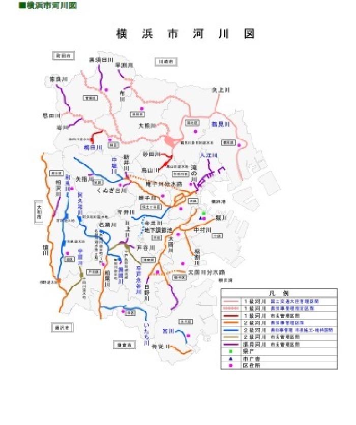
River Map of Yokohama City

Waterside Protection Association as of FY2018 (Reference)
Tozuka Public Works Office is promoting the creation of protection associations for rivers in the city.
Naze Amenity Club
Engei Juku
Sakamoto Waterside Protection Association
Na Segawa and Play Corps
Kabuki Waterside Protection Association of Naze Daiichi Neighborhood Association Fureai
AQUA Karugamo Corps
Horai Bridge Waterside Protection Association
Hira Togawa Waterside Protection Association
Shimonagaya Waterside Protection Association Green and Flower Group
Kawabe Family Garden Waterside Protection Association
Name Segawa (Sakae Bridge to Tsukimi Bridge) Waterside Protection Association
Naze River Waterside Protection Association
Kamishinano Ogawa Protection Association
Maioka River Waterfront Plaza Protection Association
Matano Neopolis Neighborhood Association Udagawa, Tando River Waterside Protection Association
Inquiries to this page
Totsuka Ward Tozuka Public Works Office
Telephone: 045-881-1621
Telephone: 045-881-1621
Fax: 045-862-3501
Email address: to-doboku@city.yokohama.lg.jp
Page ID: 146-730-831


